


Add Location
Refine Search
- hike 10
- mountain bike 7
- cave 2
- swim 2
- dive 1
- backpack 1
- camp 1
- horseback 1
- rock climb 1
- skateboard 1
11 locations
Add Location
 Full Listing
Show more
Hike, Mountain Bike
Last visited on 31 Mar 2020
Full Listing
Show more
Hike, Mountain Bike
Last visited on 31 Mar 2020
 Full Listing
Show more
Mountain Bike
Last visited on 11 Mar 2020
Full Listing
Show more
Mountain Bike
Last visited on 11 Mar 2020
 Full Listing
Show more
Hike
Last visited on 24 Jun 2019
Full Listing
Show more
Hike
Last visited on 24 Jun 2019
 Full Listing
Show more
Backpack, Camp, Hike, Horseback, Mountain Bike
Last visited on 15 Jun 2019
Full Listing
Show more
Backpack, Camp, Hike, Horseback, Mountain Bike
Last visited on 15 Jun 2019
 Full Listing
Show more
Hike, Mountain Bike
Last visited on 18 May 2019
Full Listing
Show more
Hike, Mountain Bike
Last visited on 18 May 2019
11.6 mi
 Full Listing
Show more
Dive, Hike, Mountain Bike, Swim
Last visited on 17 Jul 2020
Full Listing
Show more
Dive, Hike, Mountain Bike, Swim
Last visited on 17 Jul 2020
Toquerville Falls
La Verkin, Utah
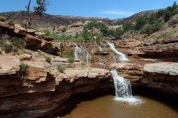
6.6 miles N of La Verkin, UtahNothing says desert oasis quite like driving for 5.5 miles through winding sandy roads to find a favorite swimming hole with ledges, falls, and even a ladder to climb up to the best jumping spots. When you've had enough of that, there's plenty of basking rocks to get your bake on. That's not to mention the great trails and beautiful views. Toquerville Falls is any adventurer's paradise with plenty of places to hike and camp in the surrounding area of the falls. The highlight of the area, of course, is Toquerville Falls itself. The swimming hole at the falls is about 7 feet deep at the deepest areas complete with a waterfall that complements the scenic beauty of the area. There are areas to jump, but it is not recommended to jump off the taller rocks, especially during the summer months when the water levels may not be as high. If you are looking to spend all day to explore this oasis, there is plenty to do and see!
Warning
courtesy of stgeorgeutah.com
The cliffs surrounding the waterfalls are brittle and slippery. Falls from these cliffs have produced several serious injuries, including this one earlier this year when a woman was life-flighted from the area after sustaining injuries from a fall. Stay away from the edges of the cliffs and refrain from jumping to avoid injuries.
Advisory
courtesy of stgeorgeutah.com
This wilderness area is in an isolated part of the vast, uninhabited desert of southwestern Utah. There is absolutely no cell phone service once you leave Toquerville, and it’s unlikely you will come across another soul on this backcountry road.
The terrain on the trail leading to Toquerville Falls is very rocky and steep in many places. A vehicle with four wheel drive is recommended to make it out to the Falls themselves.
The upper LaVerkin Creek, which feeds the Toquerville Falls, does not supply safe drinking water – cows graze this creek and the entire river system has been known to contain bacteria unsafe for humans. Unless you have a water purifier, refrain from drinking the water.
0.2-0.4 mi
 Full Listing
Show more
Cave, Hike, Mountain Bike, Rock Climb
Last visited on 27 Apr 2020
Full Listing
Show more
Cave, Hike, Mountain Bike, Rock Climb
Last visited on 27 Apr 2020
Snow Canyon State Park
St. George, Utah
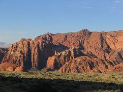
8.4 miles NW of St. George, UtahSnow Canyon State park is often described as a smaller version of Zion National park. While both offer similar beautiful landscapes, exciting trails for adventure seeking hikers, and family friendly fun, Snow Canyon offers a different and unique experience than Zion National park.
Located outside of Ivins, Utah and the Tuacahn amphitheater, Snow Canyon State park is a hidden gem that is often overshadowed by Zion National park. The park is much less busy than Zion and allows more activities within the park such as mountain biking, horseback riding, caving, rock climbing and exploring the vast desert landscape of Snow Canyon.
Surrounded by the beautiful red cliffs of Southern Utah, hikers can enjoy a wide variety of activities such as the Pioneer Names hike and rock-climbing area that allows visitors to climb up to where the original settlers of the St. George area carved their names into a rock wall. Other popular hikes in the park include, the Lava tubes trail that allows hikers to descend into ancient lava tubes and explore the underside of Snow Canyon, the Johnson Canyon trail that leads to a scenic archway that overlooks the State park, and the White rocks amphitheater trail that both hikers and horseback riders can take into a beautiful white rock oasis where the sounds of the desert can be heard without interruption.
There is much more to behold than designated trails. Your next adventure awaits at Snow Canyon State park!
0.8-2.0 mi
 Full Listing
Show more
Hike, Mountain Bike, Skateboard
Last visited on 25 Apr 2020
Full Listing
Show more
Hike, Mountain Bike, Skateboard
Last visited on 25 Apr 2020
Farmington Creek trail
Farmington, Utah
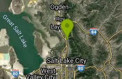
0.5 miles NW of Farmington, UtahThe Farmington Creek trail is a unique pathway that allows access to many different points of interest such as; Farmington pond, Lagoon, and Farmington Station mall. the Farmington pond route is about 0.7 miles and offers parking both at the pond, and across the street from the Lagoon park. Fishing is allowed in Farmington pond and is a great place to visit during the summer months. The trailhead that connects to the northern part of the trail leads into Farmington Canyon where the sights just begin! Along the Farmington Canyon pathway leads to Bonnie and Clyde's bullet ridden car, which could be of interest to history buffs. If continuing up the canyon, options for camping are available with a few campgrounds along the trail. If you choose to continue along the Lagoon portion of the trail, there are many sights to see as well. The trail leads behind the park where there is a small zoo where a few animals such as Elk, Buffalo, and Camels. As you continue down this part of the trail you venture in to scenic downtown Farmington, Utah and follow the creek to the Farmington Station mall. As you can see, this trail leads to fun for all regardless of your interest and activity level. There are options for biking, walking, running, rollerblading and skateboarding. If you are looking to bike or run further there are options to join the Legacy Parkway trail and the Denver/Rio Grande railroad trail which offer access to Centerville, Kaysville, and Layton.
Parrish Canyon Trail
Centerville, Utah
0.4 miles NE of Centerville, UtahParrish Canyon Trail goes long the Wasatch Mountains; from the top of the mountain, this trail has beautiful views of Salt Lake City from a distance and interconnects with the Barnard Creek. It's located in Centerville, Utah and throughout the hike, visitors are able to gain elevation until they reach the top. There are several trails that differ in difficulty for both mountain bikers and hikers to see the majestic Parrish Canyon.Located right off of Parrish lane in Centerville, Utah it is both easy to get to and find.
There's plenty of wildlife to see and a bridge to hike to if you have little ones that won't want to hike far. In the winter time, it's more beautiful but a little challenging due to the high elevation and possible wind conditions but worth it if you want great pictures. You have the option of turning back around or go further into the trail and see more scenery from the top of the mountain. There are pictographs on rocks that's visible during the spring/summer time but not so much in the winter due to snow.
Bonneville Shoreline Ogden South Of 12th
Ogden, Utah
2.3 miles E of Ogden, UtahThe most popular trail in Ogden with lots of runners, hikers, bikers, etc. Great for pre and post season but too hot during the summer unless you ride early morning. Most of it is pretty easy with a few rocky technical sections. Minor amounts of climbing and descending. Courtesy of Singletracks.com
3.6 mi
 Full Listing
Show more
Hike, Swim
Last visited on 18 Jul 2019
Full Listing
Show more
Hike, Swim
Last visited on 18 Jul 2019
Kanarraville Falls
Kanarraville, Utah
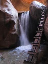
0.5 miles E of Kanarraville, UtahKanarraville falls (also known as Kanarra falls) located outside of Cedar City, Utah is a must-see stop for any adventurous souls. Kanarra Falls is a medium length hike, both on trail and through water varying from ankle to knee length in depth. Be sure to hike this trail during the summer to avoid flash flood season that starts in mid-July and ends in mid-September to ensure hiker safety and comfort by making sure water depth and speed is safe for all hikers and all levels of hiking experience.
There is a small group entrance fee due to the high volume of hikers during peak seasons. The entrance fee is $8 per hiker. Even with the entrance fee, this hike is worth every penny. Bringing small children on this hike is not recommended as the hike is more strenuous as you enter the slot canyon.
Kanarra Falls is known very well to all locals in Southern Utah, but their secret has gotten out to the rest of the State. The morning hours are best to hike this trail to avoid the busiest times where the slot canyon portion of the hike can become dangerous and hiker safety can be compromised by large gatherings in particularly narrow areas of the hike. About half way through the hike there is a swimming hole complete with a small waterfall. The swimming hole is a little overshadowed by the falls but don't let that distract you from this hidden gem. The small waterfall turns the sandstone underneath into a natural slide down to the swimming hole. The water is surprisingly deep and is a refreshing pit stop about half way through the hike. Diving is not recommended because the water is only about 8 feet deep during the peak season.
There is also lots of wildlife in the area with small fish, lizards, and deer. There are an Upper and Lower falls as you get toward the end of the trail. The Lower falls will come into view after you climb the first ladder to allow you to get in view of the falls. There is a second ladder off to the right of the falls for access to the Upper falls.
This hike is one of the many hidden gems in the St. George area. One of the few hikes that are not in a State or National park that also allows a unique experience and a peek into the beauty that surrounds Southern Utah. Kanarraville Falls is an adventerer's paradise and an experience you will not forget as you hike through this hidden desert oasis.
2.6 mi
 Full Listing
Show more
Hike
Last visited on 16 Jul 2019
Full Listing
Show more
Hike
Last visited on 16 Jul 2019
Angels Landing
Springdale, Utah
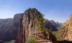
5.5 miles NE of Springdale, UtahAngels Landing is one of the park's most strenuous day hikes, but it offers spectacular vistas. It follows the West Rim Trail through the famous switchbacks of Walters Wiggles, past dramatic views at Scout Lookout, and on up to a high point 1,500 feet above the canyon floor. The steep, isolated cliff faces along this trail provide critical habitat for several species, including the peregrine falcon. This small raptor climbs, swoops, and dives with stunning power and grace, reaching speeds of over 100 miles per hour.
Walters Wiggles, an amazing series of 21 steep, stone-walled switchbacks, was carved into the cliff in the 1920s during the tenure of Superintendent Walter Ruesch. Scout Lookout, just above Walters Wiggles, offers a resting place, breathtaking views, and a preview of the very steep hike on up to Angels Landing and the canyon's West Rim. (Many people make the Lookout their destination.) Angels Landing provides one of the most dramatic vistas in Zion, across the canyon to Observation Point, Cable Mountain, and other East Rim features. The last 3/4 mile follows a narrow ridge with deadly drop-offs of 1,000 feet on either side. There are chains to hold on to in some sections, but not all. This section is not recommended for young children, those with fear of heights, or individuals with balance issues or other health concerns.
This trail is strenuous and steep, with numerous narrow sections and unprotected drop-offs. Not for anyone who is out of shape or has a fear of heights. Bring plenty of water. Start early in the day for the best conditions and be sure that you are off the trail before dark or during electrical storms.
Roundtrip: 4 hours / 4.8 miles
Elevation Gain: 1488 feet
Adams Canyon Waterfall
Layton, Utah
3.2 miles E of Layton, UtahAdams Canyon is easily the most popular hike in Layton, Utah, and one of the best-loved waterfall hikes on the Wasatch Front, a lush canyon climb that leads to not one but two beautiful waterfalls tucked into the mountains above town. Reached from a single trailhead on the eastern edge of Layton, it delivers a genuine mountain-canyon experience, running water, shade, and a dramatic falls, remarkably close to the suburbs of the Salt Lake Valley's northern reaches.
The trail offers two destinations from the same start. The Lower Falls is a roughly 20-foot cascade only about 20 minutes and a mile or so from the trailhead, an easy, family-friendly goal that makes a great short outing. The Upper Falls, the main event for most hikers, is a striking 40-foot waterfall about two hours in, reached by a steeper, more sustained climb up the canyon alongside the creek. The full hike to the Upper Falls and back takes most people a few hours and is rated easy-to-moderate, though it earns its "moderate" on the steeper pitches.
The canyon is genuinely pretty, with the creek for company much of the way, stands of trees for shade, and the payoff of the falls at the top, which is exactly why it draws such crowds. April through October is the most popular window, with spring bringing the fullest flow and green canyon, and fall adding color.
A firm safety note governs the top of the hike. Hiking above the waterfalls is not permitted, because the terrain up there is slippery and dangerous, and people have gotten into serious trouble venturing past the falls. The Upper Falls is the turnaround point; the wet rock around and above it is genuinely hazardous, so the falls are the destination, not a waypoint to climb beyond.
Because it's so popular and close to town, the trailhead parking (at roughly 600 Eastside Drive in Layton) fills fast, especially on weekends and holidays, so an early start helps both for parking and for a quieter trail. The lower stretch has some sandy switchbacks that can be warm and exposed, while the upper canyon is shadier and cooler near the water.
Come with plenty of water, sturdy shoes with good grip for the steeper and wetter sections, sun protection for the lower switchbacks, and a willingness to turn around at the Upper Falls. For a genuinely rewarding two-waterfall hike minutes from Layton, Adams Canyon is a Wasatch Front classic for good reason.
Antelope Island State Park
Syracuse, Utah
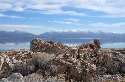
10.0 miles SW of Syracuse, UtahLocated just 41 miles north of Salt Lake City, Antelope Island State Park encompasses a vast selection of outdoor activities and spectacular scenery providing a peaceful nature experience. Experience stunning 360-degree views as you drive around the State Park or try other activities such as exploring the roughly 20 miles of trails open for hiking, biking, and running or horseback riding. Picnic tables and designated campsites are available though RV hookups are not provided.
Enjoy the water as you kayak, fish, sail, or swim off of the Great Salt Lake’s largest island. Wild animals such as antelope, birds, bison, bobcats, coyotes, deer, and horned sheep roam freely and claim Antelope Island home. Watching the wildlife is a must. Be sure to take caution around wildlife and keep your distance. Do not touch or feed wildlife.
Absorb the beauty of nature through spectacular sunrises, sunsets, and the spectacular night sky. The Visitor Center includes publications, restrooms, and exhibits for all to enjoy. The best times of year for exploring Antelope Island are early spring an late fall. Beware of the bug situation in late spring and early summer. Bug spray is mandatory. Don't forget to bring drinking water as well to stay hydrated during your adventures.
Great Salt Lake Shorelands Preserve
Layton, Utah
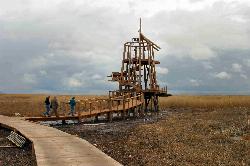
3.0 miles W of Layton, UtahThe Great Salt Lake Shorelands Preserve is a hidden gem on the eastern edge of the Great Salt Lake near Layton, Utah, where a mile-plus of boardwalk floats out over a living wetland that most people driving I-15 never know is there. Owned and managed by The Nature Conservancy, the preserve protects a stretch of marsh that provides essential habitat for over 250 species of birds, and it offers all of it up to visitors on a flat, easy, genuinely beautiful walk, for free.
The boardwalk is the experience. The main loop runs about 1.3 miles on a spongy raised walkway laid directly over the marshes of the northern Great Salt Lake, taking most people around 20 to 30 minutes at a stroll, or far longer with binoculars in hand. It's flat and accessible, which makes it one of the rare wild places genuinely suited to all ages and abilities, and it comes with a viewing tower, educational signage and even an audio tour to interpret what you're seeing.
Birding is the headline. Between four and six million birds use the Great Salt Lake each year to feed, rest and nest, and the preserve puts you right in the middle of that traffic, with the best activity early in the morning and again in the couple of hours before sunset when everything is feeding. Spring and fall migrations bring the biggest numbers and the widest variety; the marsh is busy and loud with life at the right hour.
Facilities are excellent for a preserve: solid parking, restrooms, a visitor center and clear interpretive exhibits about the lake's birdlife and why the habitat matters. The visitor center runs roughly 7 a.m. to 8 p.m. April through September and 8 a.m. to 5 p.m. October through March. Admission is free. One firm rule to know before you go: dogs are not allowed on the boardwalk, to protect the birds and the fragile wetland.
This is an exposed lakeside wetland, so it can be buggy in the warm months, windy off the lake, and hot at midday with essentially no shade, which is another reason the early and late hours are best. Sunsets over the marsh and the lake beyond are, by wide agreement, spectacular.
Come with binoculars, sun protection, insect repellent in summer, and water. Time your visit to dawn or dusk, tread lightly on the boardwalk, and leave the dog at home. For a free, easy, deeply rewarding hour with one of the most important bird habitats in the West, the Shorelands Preserve is hard to beat.
0.7 mi
 Full Listing
Show more
Cave, Hike
Last visited on 5 Apr 2019
Full Listing
Show more
Cave, Hike
Last visited on 5 Apr 2019
Snow Canyon Lava Caves
St. George, Utah
9.6 miles NW of St. George, UtahThese caves are located in Snow Canyon State Park near Dammeron Valley in Utah and it's one of the most unique places in southern Utah. Years ago, lava flowed through these caves until it froze until formed into a tunnel, so the volcano has been inactive since. The trail is filled with lava rocks, sand and gravel, and there are several lava tubes which can be entered, so wearing closed toe shoes and using good balance will make the trip to the caves easier. The largest cave is before the trail drops into the valley to connect to West Canyon Road. To the south of this point, there's a pyramidal shaped slick rock hill, which you can easily go up from the west side. You will need to carefully climb to the hike into the cave that starts with a fairly large opening. Once you get into the cave, there will be a small opening where the hike downward begins. You will hike through a confining space with some low ducking areas, until finally you will reach a large room; which is the ending of the cave.
The cave also features historical artifacts and geological features and you can learn about this cave's past by visiting one or all of the five Native American petroglyph sites. The petroglyph trail has a round trip of 5 miles, moderate difficulty hiking level and the average hiking time is 2-3 hours.There are 5 petroglyph sites:
- By the campground:
It's on the edge of the campground, on the sandstone cliff adjacent to the last camping spot. It is easy to find. The images are old and faded, many covered with patina, but well worth seeing. Courtesy of redrockadventure.com
- The Crack:
On the east side of the park, just SW of The Ledges golf course and development. A parking area and corridor that provides access to the park can be found at the end 4200 N Street (a St George city street just south of The Ledges). From that parking area, hike west into the park and then follow a trail that appears and disappears at times, working your way down into the canyon. Wander a bit and you will find the slot. It is a fun family hike. Many of the images are faded and difficult to see, but well worth hunting down. Courtesy of redrockadventure.com
- Main Slot:
Above that crack, the main canyon narrows and there is a dryfall. Above it, in a deep slot, there are many interesting rock art images. Courtesy of redrockadventure.com
- Top of Canyon:
Near the top of that same canyon there is a dark panel with perhaps the best images in Snow Canyon. Courtesy of redrockadventure.com
- The Ledge:
Some call this panel "Newspaper Rock." It is just north of the canyon mentioned above and is a prominent boulder with extensive rock art figures on its north side. It is located due west from The Ledges and it is up on top of the ridge, not down in the canyon. The best access comes from using the corridor described above.Courtesy of redrockadventure.com
Things to remember: Bring flashlights and extra batteries. No littering or graffiti in and around the caves, both are illegal and if done, the caves will be closed temporarily until they are clean. Be respectful and responsible. To return to the parking area, make a loop return on the White rocks Trail or return to the parking lot on the same trail.
×


