


Kanarraville Falls
Kanarraville, Utah
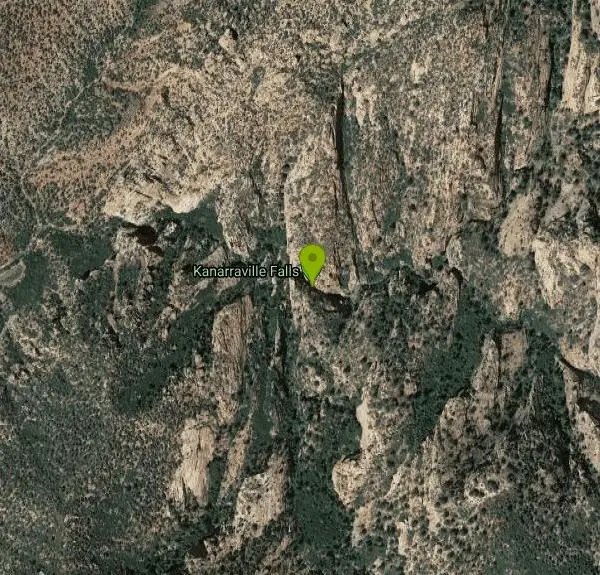
| Address: | Kanarraville Falls, Cedar City, UT 84720, USA |
| GPS: |
37°32'13.8"N 113°10'33.7"W Maps | Directions |
| State: | Utah |
| Trail Length: | 4.40 miles |
| Trail Type: | Out & Back |
| Hike Difficulty: | Intermediate |
| Trails/Routes: | 3.6 mi |
Restrooms Rivers Waterfalls Streams Trails Rocks Ponds Pet Friendly Picnic Tables
Hike and Swim
Kanarraville falls (also known as Kanarra falls) located outside of Cedar City, Utah is a must-see stop for any adventurous souls. Kanarra Falls is a medium length hike, both on trail and through water varying from ankle to knee length in depth. Be sure to hike this trail during the summer to avoid flash flood season that starts in mid-July and ends in mid-September to ensure hiker safety and comfort by making sure water depth and speed is safe for all hikers and all levels of hiking experience.
There is a small group entrance fee due to the high volume of hikers during peak seasons. The entrance fee is $8 per hiker. Even with the entrance fee, this hike is worth every penny. Bringing small children on this hike is not recommended as the hike is more strenuous as you enter the slot canyon.
Kanarra Falls is known very well to all locals in Southern Utah, but their secret has gotten out to the rest of the State. The morning hours are best to hike this trail to avoid the busiest times where the slot canyon portion of the hike can become dangerous and hiker safety can be compromised by large gatherings in particularly narrow areas of the hike. About half way through the hike there is a swimming hole complete with a small waterfall. The swimming hole is a little overshadowed by the falls but don't let that distract you from this hidden gem. The small waterfall turns the sandstone underneath into a natural slide down to the swimming hole. The water is surprisingly deep and is a refreshing pit stop about half way through the hike. Diving is not recommended because the water is only about 8 feet deep during the peak season.
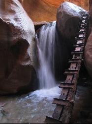
There is also lots of wildlife in the area with small fish, lizards, and deer. There are an Upper and Lower falls as you get toward the end of the trail. The Lower falls will come into view after you climb the first ladder to allow you to get in view of the falls. There is a second ladder off to the right of the falls for access to the Upper falls.
This hike is one of the many hidden gems in the St. George area. One of the few hikes that are not in a State or National park that also allows a unique experience and a peek into the beauty that surrounds Southern Utah. Kanarraville Falls is an adventerer's paradise and an experience you will not forget as you hike through this hidden desert oasis.
More Information
Be courteous, informed, and prepared. Read trailhead guidelines, stay on the trail, and don't feed the wildlife.
Read More- Plan Ahead and Prepare
- Travel & camp on durable surfaces
- Dispose of waste properly
- Leave what you find
- Minimize campfire impacts
- Respect wildlife
- Be considerate of other visitors
Directions
From Kanarraville, Utah
- Head north on 100 W (36 ft)
- Turn right at the 1st cross street onto W 100 N St (0.5 mi)
 Ladder At Kanarraville courtesy of The Greater Southwestern Exploration Company↗


 Beginning of trail to Kanarra Falls by Tyler Burgener
 Kanarra Falls trail added by torontoty1214
 Slot canyon section of Kanarra Falls by Tyler Burgener
 Beginning of Slot canyon by Tyler Burgener
 Swimming hole about half way through Kanarra Falls trail by Tyler Burgener
 Climbing the ladder to get to the upper falls by Tyler Burgener


Added by torontoty1214
Trails
Distance ?
3.6 miles Round TripElevation Gain ?
487 feetReal Ascent ?
1,125 feetReal Descent ?
638 feetAvg Grade (3°)
5%Grade (-41° to 48°)
-87% to 111%Elevation differences are scaled for emphasis. While the numbers are accurate, the cut-away shown here is not to scale.
Other Swimming Holes and Hiking Trails Nearby
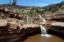
Toquerville Falls
La Verkin, Utah
16.9 miles SNothing says desert oasis quite like driving for 5.5 miles through winding sandy roads to find a favorite swimming hole with ledges, falls, and even a ladder to climb up to the best jumping spots....
Dive, Hike, Mountain Bike, Swim 7.5 mi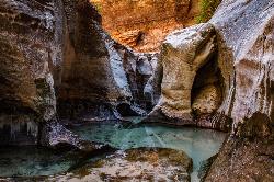
The Subway
Apple Valley, Utah
17.2 miles SEThe Subway is one of the best kept secrets of Zion National Park. A little off the beaten path, but a hike that is a must see for any adventure seeking person out there. Hikers begin at the Wildcat...
Canyoneer, Hike, Swim
Riverside Walk
Springdale, Utah
21.2 miles SEThe Virgin River has many moods, from quiet and slow to a raging torrent. This beautiful, shaded walk meanders through forested glens, following the path of the stream ever deeper into the...
Hike 3.3 mi
Guacamole Mesa
Virgin, Utah
21.7 miles SGuacamole Mesa, also known by locals as the Whole Guacamole, is an advanced level biking trail in Virgin, Utah (just outside of Hurricane). The trail starts in a climb up the mesa that features tight...
Hike, Mountain Bike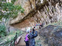
Weeping Rock
Springdale, Utah
22.6 miles SEExpect to get wet on this short hike! Weeping Rock gets its name from the continuous "weeping" of water that seeps through sandstone and drips from the cliffs above. Seasonal flowers...
Hike 2.6 mi
Angels Landing
Springdale, Utah
22.8 miles SEAngels Landing is one of the park's most strenuous day hikes, but it offers spectacular vistas. It follows the West Rim Trail through the famous switchbacks of Walters Wiggles, past dramatic...
Hike
The Grotto Trail
Springdale, Utah
22.9 miles SEThe Grotto Trail is a short easy trail that connects The Grotto shuttle stop and Zion Lodge. It follows near the road for about 1.5 miles and has an elevation gain of about 130 feet.
Hike 1.1 mi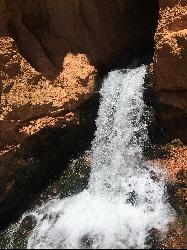
Cascade Falls
Cedar City, Utah
23.1 miles ECascade Falls, located outside of Cedar City, Utah, is a beautiful waterfall that is just a 1.2 mile hike round trip, ending at Cascade Falls. It is somewhat of a hidden local hotspot that not...
Hike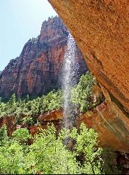
Emerald Pools Trail
Hurricane, Utah
23.1 miles SEThe Emerald Pools were named for their unusual color. At some times of the year, algae gives the water in these pools a distinctive hue. A series of basins have been carved into a rock ledge in the...
Hike 6.9 mi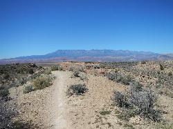
J.E.M. Trail
La Verkin, Utah
23.5 miles SThe J.E.M. trail is one of the many exciting trails located just outside of Hurricane, Utah. It is connected with the More Cowbell and Dead Ringer trails and is the longest of all three trails...
Hike, Mountain Bike 0.7 mi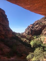
Red Reef trail
Hurricane, Utah
25.1 miles SWThe Red Reef trail is located near the small town of Leeds, Utah and in the Red Cliffs Desert Reserve. It is a 2 mile trail that takes hikers near the beautiful red slick rock cliffs of Southern...
Hike
Zion National Park
Hurricane, Utah
25.3 miles SEThis is a unique place in the world. Sandstone,carved from wind, water and ice have created icons to visitors. The buttes, landings, bends, mounts and mountains have all been given names over the...
Camp, Hike, Mountain Bike, Swim 5.1 mi
Dead Ringer
Virgin, Utah
27.8 miles SThe Dead Ringer trail is one of three biking trails located just outside of Hurricane, Utah. Starting at the JEM trailhead, bikers start on a winding, up and down trail that runs parallel to the JEM...
Hike, Mountain Bike 3.4 mi
More Cowbell
Virgin, Utah
27.8 miles SThe More Cowbell loop, located outside of Hurricane, Utah, is a beginner level bike trail that gives riders a good feel for what mountain biking is like. It is a great practice run for bigger, more...
Hike, Mountain Bike
Dixie National Forest
Cedar City, Utah
28.8 miles EDixie National Forest is an often forgotten/hidden gem in Cedar City. It is over 2 million acres of beautiful red rock canyons and trees. Dixie Forest isn't only limited to rocks and...
Backpack, Camp, Hike
Sand Hollow State Park
Hurricane, Utah
31.0 miles SSand Hollow is the closest thing to a tropical paradise in the middle of the Utah desert, near Hurricane, Utah. It features a beach area, places to cliff jump, swim, and off-road with your ATV. There...
Camp, Canoe, Dive, Kayak, Swim 11.3 mi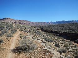
Grapevine Trail
Washington, Utah
31.9 miles SWThe Grapevine trail located near Washington, UT is a unique trail that connects to several other trails in the area such as the Prospector trail and the Church Rocks trail. What makes the Grapevine...
Hike, Mountain Bike 18.8 mi
Church Rocks
Washington, Utah
32.0 miles SWThe Church Rocks hike near Hurricane, Utah, about a half hour outside of St. George, is another hidden gem outside of Zion National Park. Similar to the Slick Rock Trail in Moab, there are lots...
Hike, Mountain Bike 0.7 mi
Snow Canyon Lava Caves
St. George, Utah
33.6 miles SWThese caves are located in Snow Canyon State Park near Dammeron Valley in Utah and it's one of the most unique places in southern Utah. Years ago, lava flowed through these caves until...
Cave, Hike 0.2-0.4 mi
Snow Canyon State Park
St. George, Utah
34.5 miles SWSnow Canyon State park is often described as a smaller version of Zion National park. While both offer similar beautiful landscapes, exciting trails for adventure seeking hikers, and family friendly...
Cave, Hike, Mountain Bike, Rock ClimbNearby Campsites
Zion National Park
Hurricane, Utah
25.3 miles SEThis is a unique place in the world. Sandstone,carved from wind, water and ice have created icons to visitors. The buttes, landings, bends, mounts and mountains have all been given names over the...
Camp, Hike, Mountain Bike, Swim
Dixie National Forest
Cedar City, Utah
28.8 miles EDixie National Forest is an often forgotten/hidden gem in Cedar City. It is over 2 million acres of beautiful red rock canyons and trees. Dixie Forest isn't only limited to rocks and...
Backpack, Camp, Hike
Sand Hollow State Park
Hurricane, Utah
31.0 miles SSand Hollow is the closest thing to a tropical paradise in the middle of the Utah desert, near Hurricane, Utah. It features a beach area, places to cliff jump, swim, and off-road with your ATV. There...
Camp, Canoe, Dive, Kayak, Swim


