


Wrightsville Beach
Middlesex

Canoe, Hike, Kayak, and Swim
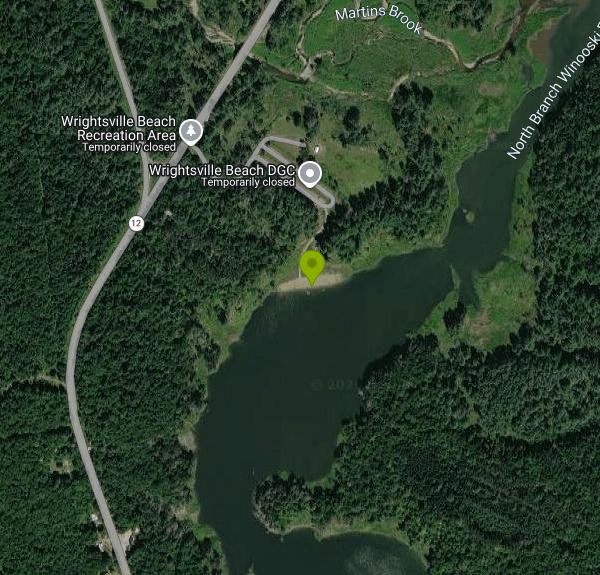
Wrightsville Beach is the sand swimming beach and day use area on the west shore of Wrightsville Reservoir, at 369 VT Route 12 in the town of Middlesex, about six miles north of downtown Montpelier. It is run by the Wrightsville Recreation District, an intermunicipal recreation district funded per capita by its four member towns: Montpelier, East Montpelier, Middlesex and Worcester. The reservoir itself sits behind Wrightsville Dam, a flood-control dam on the North Branch of the Winooski River that Civilian Conservation Corps crews built between 1933 and 1935 after the 1927 flood. The State of Vermont's Department of Environmental Conservation owns the dam.
From Montpelier, follow Elm Street north until it becomes Route 12. About five miles out you pass the state boat launch on the right; keep going roughly half a mile and turn right at the sign for the Beach and Picnic Area, not the Boat Launch. Park in the main lot and check in at the booth near the beach before you set up. The gate is locked at dusk, and cars left inside after that get shut in.
You swim from a designated area off a sandy beach backed by a grassy lawn. There is no lifeguard, so swimming is at your own risk, and anyone under 14 must be with an adult. Fishing is allowed only 50 feet or more to the left of the swim area. The district tests the swim water for E. coli several times each summer and posts the results online and at the beach; every 2026 sample came in between 0 and 22 colonies per 100 ml, far below Vermont's limit of 235. No glass, no alcohol on the beach or in the Pines picnic area, no smoking on the beach, and no dogs from late May through Labor Day (service dogs with documentation excepted).
This is not a free beach. Under the most recent day rates the district posted (the 2025 schedule), entry costs $4 for ages 19 to 63, $3 for ages 13 to 18, $3 for seniors 64 and up, $2 for children 3 to 12 with an adult, and nothing for children under 3. Disc golf adds $1.50 for players 13 and older. Season passes start at $34 for an individual, and residents of the four district towns get 10 percent off season passes. The beach runs from late May through Labor Day, with reduced shoulder-season hours into September in some years; it has closed for the 2026 season and the district plans to reopen in late May 2027. Confirm 2027 rates at the booth or on the district's site.
Because the reservoir exists to hold back floodwater, its level can jump after several days of heavy rain. Normal pool is about 635 feet above sea level; above 640 feet the whole sand beach is underwater, and above 654 feet most of the lower park floods and the beach closes. The 2024 flood destroyed the old small shelter, which was replaced with a new Westside shelter for 2026.
Beyond the beach the park has an 18-hole disc golf course in the woods beside the water, lakeside walking trails, a recreation field, shaded tables and grills in the Pines picnic area, reservable shelters, pit toilets, well water and a small snack counter. Kayaks, canoes and paddleboards rent at the booth for $17 to $20 for the first hour and $10 for each added hour (40 percent off on Tuesdays), plus the day fee.
More Information
Directions - Wrightsville Beach VT
Wrightsville's located about 6 miles North of Downtown Montpelier, VT on Route 12. Look for the "Beach & Picnic Area" sign, not the "Boat Launch" . From I-89 head towards Downtown Montpelier > left...
https://www.wrightsvillebeachvt.com/directions.htmlthe 4 District Town explanation - Wrightsville Beach VT
The District Towns are Middlesex, Montpelier, East Montpelier, and Worcester. Each of these towns contributes a dollar amount per capita to support the ongoing maintenance of Wrightsville Beach and...
https://www.wrightsvillebeachvt.com/the-4-district-town-explanation.htmlWater Level Explanation - Wrightsville Beach VT
To check the current water level CLICK HERE . The water level can fluctuate greatly following extremely heavy or extended (multiple consecutive days) periods of heavy rain. If we recently received...
https://www.wrightsvillebeachvt.com/water-level-explanation.htmlWater Quality - Wrightsville Beach VT
Wrightsville Beach Season Details
https://www.wrightsvillebeachvt.com/water-quality.htmlWrightsville Beach Open for Labor Day Weekend! - Central Vermont Regional Planning Commission
Well, it looks like summer finally made it to Vermont. Better late than never! Why not celebrate summer's last "official" weekend at the Wrightsville Beach Day Use Area? The forecast is for sun and 80 degree temperatures, the water is still warm, and the Beach offers a variety of recreation choices, including swimming, picnicking, trails,
https://centralvtplanning.org/?p=615Wrightsville Beach VT - Home
The best value for a day outside, beach, boats, disc golf, multi-use trails, picnic area, reservable shelters. Season passes available too
https://www.wrightsvillebeachvt.com/Wrightsville Dam - Updates and Ongoing Projects | Department of Environmental Conservation
Home About DEC Contact Us Stream Biomonitoring Administration and Innovation Air Quality and Climate Drinking Water and Groundwater Environmental Assistance Environmental Enforcement Geological Survey Waste Management and Prevention Water Investment Applications and Forms News and Public Notices Meetings and Events Funding Opportunities Resources, Publications and Reports Statutes, Rules and Policies Permits, Orders and Approvals Clean Water Initiative Program Dam Safety Program DEC-Owned Dams Waterbury Dam Spillway Project Wrightsville Dam Dam Safety Statute and Rules Dam Orders (Permits) Inspection Program Vermont Dam Inventory (VDI) Dam Ownership and Responsibility Unsafe Dam State Revolving Fund DSP Newsletters Living Near Dams Dam Safety Awareness Day Noyes Pond Dam Safety Improvements Silver Lake Dam Safety Improvements Amherst Lake Risk Reduction Measures Water Infrastructure Financing Programs Watershed Planning Program Agency Facilities Engineering Section WID Site Map Contacts Watershed Management Commissioner’s Office Permits and Certifications Funding Opportunities Maps and GIS Laws and Regulations Village Wastewater Solutions Initiative Vermont PFAS VAEL Laboratory VTWARN Agency of Natural Resources Lake Carmi Search Submit Home About DEC Contact Us Stream Biomonitoring Administration and Innovation Air Quality and Climate Drinking Water and Groundwater Environmental Assistance Environmental Enforcement Geological Survey Waste Management and Prevention Water Investment Applications and Forms News and Public Notices Meetings and Events Funding Opportunities Resources, Publications and Reports Statutes, Rules and Policies Permits, Orders and Approvals Clean Water Initiative Program Dam Safety Program DEC-Owned Dams Waterbury Dam Spillway Project Wrightsville Dam Dam Safety Statute and Rules Dam Orders (Permits) Inspection Program Vermont Dam Inventory (VDI) Dam Ownership and Responsibility Unsafe Dam State Revolving Fund DSP Newsletters Living Near Dams Dam Safety Awareness Day Noyes Pond Dam Safety Improvements Silver Lake Dam Safety Improvements Amherst Lake Risk Reduction Measures Water Infrastructure Financing Programs Watershed Planning Program Agency Facilities Engineering Section WID Site Map Contacts Watershed Management Commissioner’s Office Permits and Certifications Funding Opportunities Maps and GIS Laws and Regulations Village Wastewater Solutions Initiative Vermont PFAS VAEL Laboratory VTWARN Agency of Natural Resources Lake Carmi Wrightsville Dam - Updates and Ongoing Projects Updated: September 2026
https://dec.vermont.gov/wrightsville-damBe courteous, informed, and prepared. Read trailhead guidelines, stay on the trail, and don't feed the wildlife.
Read More
- Plan Ahead and Prepare
- Travel & camp on durable surfaces
- Dispose of waste properly
- Leave what you find
- Minimize campfire impacts
- Respect wildlife
- Be considerate of other visitors
Directions
From Middlesex
- Head west on Kearney Ave toward Old Matawan Rd (0.1 mi)
- Turn right onto Old Matawan Rd (0.3 mi)
- Continue onto Matawan Rd (0.2 mi)
- Turn right onto Main St (0.3 mi)
- Continue onto Bordentown Ave (5.1 mi)
- Turn right toward US-9 N (440 ft)
- Merge onto US-9 N (0.4 mi)
- Slight right onto the Garden State Parkway ramp (0.2 mi)
- Merge onto Garden State Pkwy N (4.6 mi)
- Take exit 129 for I-95 N toward New York CityToll road(1.2 mi)
- Take the ramp onto I-95 NToll road(14.4 mi)
- Keep left to stay on I-95 N, follow signs for I-80 W/
Lincoln Tunnel Toll road(6.5 mi) - Keep left to stay on I-95 N (6.4 mi)
- Keep right to stay on I-95 N, follow signs for George Washington Brg/
Fort Lee (3.2 mi) - Continue straight to stay on I-95 N (signs for GW Bridge (Lower Level)) (0.1 mi)
- Keep right to stay on I-95 N, follow signs for US-1 N/
US-9 N/ George Washington Bridge (0.4 mi) - Continue onto US-9 N (456 ft)
- Continue onto I-95 Lower Level N/
U.S. 1 Lower Level N Toll roadEntering New York(1.5 mi) - Keep right to continue on Cross Bronx Expy/
I-95 Lower Level N/ Trans-Manhattan Expy/ U.S. 1 Lower Level N (0.8 mi) - Cross Bronx Expy/
I-95 Lower Level N/ Trans-Manhattan Expy/ U.S. 1 Lower Level N turns right and becomes I-95 N/ Cross Bronx Expy (0.1 mi) - Take exit 1C-D to merge onto I-87 N toward Albany (7.1 mi)
- Take exit 4 toward Cross Cnty Pkwy (453 ft)
- Merge onto Central Park Ave (0.1 mi)
- Slight right onto the Cross County Pkwy ramp (404 ft)
- Take the ramp to Hutchinson Pkwy (0.2 mi)
- Merge onto Cross County Pkwy (1.9 mi)
- Keep left to stay on Cross County Pkwy, follow signs for N Hutchinson Pkwy/
Merritt Pkwy (1.2 mi) - Merge onto Hutchinson Riv Pkwy N (6.4 mi)
- Keep left to stay on Hutchinson Riv Pkwy NEntering Connecticut(4.4 mi)
- Continue onto CT-15 N (63.9 mi)
- Take the exit on the left onto I-91 NEntering Massachusetts(47.4 mi)
- Slight left to stay on I-91 N (signs for Greenfield)Entering Vermont(117 mi)
- Take exit 10B to merge onto I-89 N toward Barre/
Montpelier (52.5 mi) - Take exit 8 toward US-2/
Montpelier (0.2 mi) - Continue onto Memorial Dr (0.8 mi)
- Turn left onto Bailey Ave/
Bailey Ave Ext (0.2 mi) - Turn right onto State St (0.4 mi)
- Turn left onto Elm St (3.4 mi)
- Continue onto VT-12 N (1.9 mi)
- Turn rightRestricted usage road(0.1 mi)
- Turn rightRestricted usage road(489 ft)


Other Swimming Holes, Hiking Trails, Canoeing Areas, and Kayaking Areas Nearby
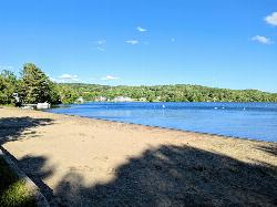
Elmore State Park Beach
Lake Elmore
14.8 miles NSandy, shallow swim beach at the north end of Lake Elmore in Elmore State Park, Vermont, with a CCC-built beach house, boat rentals and a $5 adult day-use fee.
Camp, Canoe, Hike, Kayak, Swim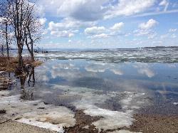
Blanchard Beach at Oakledge Park
Burlington
33.2 miles WSandy, shallow city beach on Lake Champlain in Burlington's Oakledge Park. Free on foot or bike, $3/hour parking May through October, no lifeguards, and frequent algae checks in summer.
Hike, Swim
Swiftwater Bridge
Bath, New Hampshire
33.8 miles SESwim near Bath, New Hampshire
Swim
Weare
Bath, New Hampshire
33.8 miles SESwimmable river pools up to 4 feet deep along a Weare, New Hampshire roadside, including a 30-foot-wide section with a rope swing — rocky terrain means caution is advised, especially for small children.
Swim
Leddy Beach
Burlington
35.5 miles WFree city swimming beach on Lake Champlain at Leddy Park in Burlington's New North End, with free parking, a sandy shore and daily water monitoring in summer, but no lifeguards.
Hike, Swim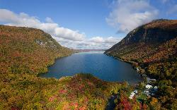
Southwest Cove
Westmore
37.7 miles NEA sand beach at the southwest corner of Lake Willoughby in Willoughby State Forest, reached by a short trail from the south end lots. Free, cold, clear water, no lifeguards, and long used as a clothing-optional beach.
Canoe, Hike, Kayak, Swim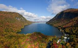
Lake Willoughby South Beach
Westmore
37.9 miles NEA free public beach at the south tip of Lake Willoughby in Westmore, Vermont, with the cliffs of Mount Pisgah and Mount Hor rising on either side of deep, clear, cold water.
Canoe, Hike, Kayak, Swim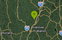
Union Village Dam Recreation Area
Thetford Center
38.5 miles SESandy Beach is a free river beach on the Ompompanoosuc inside the Army Corps' Union Village Dam Recreation Area, half a mile down Buzzell Bridge Road from Thetford Center. No lifeguards, no pets on the beach.
Hike, Swim
Burton Island State Park
St. Albans
43.4 miles NWCar-free Burton Island in Lake Champlain has a rocky, unguarded swim area by the marina, reached by the state's 10-minute Island Runner ferry from Kill Kare State Park. State day-use and ferry fees apply.
Camp, Canoe, Hike, Kayak, Swim
Horseshoe Falls
Lincoln, New Hampshire
46.7 miles ECLOSED. Private Property. Closed to the public due to vandalism. Please take better care of areas we're permitted to use.
Swim
Falling Waters
Lincoln, New Hampshire
46.7 miles ESwim near Lincoln, New Hampshire
Swim
Lincoln Area
Lincoln, New Hampshire
46.7 miles EA cluster of swimming options near the busy tourist town of Lincoln, New Hampshire — some spots clothing-optional; see local listings for details.
Swim
Port Henry Beach
Port Henry
47.7 miles SWA free town beach on Lake Champlain at the north end of Bulwagga Bay, run by the Town of Moriah with lifeguards on duty from mid June through Labor Day. Free kayaks and paddleboards, a fishing pier and a campground share the same stretch of shore.
Camp, Canoe, Kayak, SwimNearby Campsites
Elmore State Park Beach
Lake Elmore
14.8 miles NSandy, shallow swim beach at the north end of Lake Elmore in Elmore State Park, Vermont, with a CCC-built beach house, boat rentals and a $5 adult day-use fee.
Camp, Canoe, Hike, Kayak, Swim
Burton Island State Park
St. Albans
43.4 miles NWCar-free Burton Island in Lake Champlain has a rocky, unguarded swim area by the marina, reached by the state's 10-minute Island Runner ferry from Kill Kare State Park. State day-use and ferry fees apply.
Camp, Canoe, Hike, Kayak, Swim
Maple Haven Campground
Woodstock, New Hampshire
44.0 miles SEA private 28-acre campground tucked in the heart of New Hampshire's White Mountains with breathtaking views, untouched nature, and both indoor and outdoor camping options.
Camp
Port Henry Beach
Port Henry
47.7 miles SWA free town beach on Lake Champlain at the north end of Bulwagga Bay, run by the Town of Moriah with lifeguards on duty from mid June through Labor Day. Free kayaks and paddleboards, a fishing pier and a campground share the same stretch of shore.
Camp, Canoe, Kayak, Swim


