


8038 Things to do in United States
first prev 1 2 3 4 5 6 7 8 9 10 next lastShowing results in United States City, Zip, or Address

Randy's Cow Trail / Ken's Corner
Ririe, Idaho
7.5 miles E of Ririe, IdahoThis trail descends from the fence corner at the West end of Batman and continues down to Lyon's Creek Parking just off Lyon's road. The top of this trail is only a couple hundred yards from...
Mountain Bike 5.9-9.1 mi
Sand Point
Forks, Washington
19.2 miles NW of Forks, WashingtonBackpack and Hike near Forks, Washington
Backpack, Hike 0.1-1.1 mi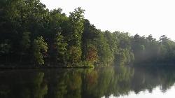
Durant Nature Preserve
Raleigh, North Carolina
8.6 miles NE of Raleigh, North CarolinaVisiting Durant Nature Preserve is an opportunity for people in the bustling cities of Raleigh and Wake Forest to connect with nature. This nature preserve stretches over 237 acres. There...
Hike, Mountain Bike 1.4 mi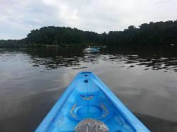
Queen Anne Creek
Edenton, North Carolina
0.2 miles W of Edenton, North CarolinaLocals in Edenton recommend Queen Anne Creek for great kayaking and canoeing. To begin this adventure park your car at the Roanoke River Lighthouse and head across the park to the...
Canoe, Kayak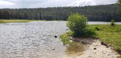
Pintler Lake Campground and Picnic Area
Wise River, Montana
23.4 miles W of Wise River, MontanaCamp, Canoe, Kayak, and Swim near Wise River, Montana
Camp, Canoe, Kayak, Swim 0.7-2.0 mi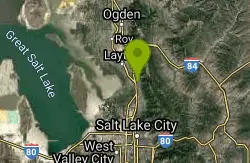
Farmington Creek trail
Farmington, Utah
0.5 miles NW of Farmington, UtahThe Farmington Creek trail is a unique pathway that allows access to many different points of interest such as; Farmington pond, Lagoon, and Farmington Station mall. the Farmington pond route is...
Hike, Mountain Bike, Skateboard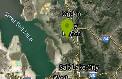
Great Salt Lake Shorelands Preserve
Layton, Utah
3.0 miles W of Layton, UtahBeautiful scenery with great trails that are close to the shoreline of the Great Salt Lake. Great for any skill level or just a leasurly walk on a beautiful day.
Hike, Mountain Bike 3.6 mi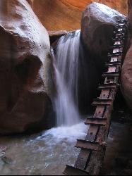
Kanarraville Falls
Kanarraville, Utah
0.5 miles E of Kanarraville, UtahKanarraville falls (also known as Kanarra falls) located outside of Cedar City, Utah is a must-see stop for any adventurous souls. Kanarra Falls is a medium length hike, both on trail and through...
Hike, Swim 1.2 mi
Mule Hollow
Elkins, West Virginia
10.1 miles SE of Elkins, West VirginiaMule Hollow is a more private swimming hole just outside of Bemis. The swimming hole itself is located in Shaver's Fork river, and is a deep pool with little current from the river felt as you...
Swim
Chavez Crossing
Sedona, Arizona
2.1 miles SW of Sedona, ArizonaChavez Crossing is a campground in Sedona, Arizona. It sits perfectly nestled in Arizona's most beautiful red rock attractions along with the grand summer sunsets. If that didn't sound...
Camp, Hike, Swim
Mesa Falls
Ashton, Idaho
10.0 miles NE of Ashton, IdahoUpper Mesa Falls, aka Big Falls, is an absolutely awesome waterfall on the Henrys Fork of the Snake River. The falls drop 114 ft. and measure 300 ft. across. To get to the falls from the parking lot...
Cross-country Ski, Hike, Kayak 0.6-4.7 mi
Harriman State Park
Island Park, Idaho
8.3 miles SW of Island Park, IdahoHarriman State Park is found 38 miles from Yellowstone along Henry's Fork. This 11,000-acre wildlife refuge is open year round for most activities. In addition to having beautiful scenery and...
Cross-country Ski, Hike, Horseback, Mountain Bike, Snowshoe 0.8 mi
Conant Creek Pegram Truss Railroad Bridge
Ashton, Idaho
5.0 miles SE of Ashton, IdahoAs part of the Rails to Trails project, this old railroad bridge has been transformed into a very safe little viewing experience for the whole family. You can drive right up to the bridge where there...
Hike 0.3-0.6 mi
Bear Gulch
Ashton, Idaho
9.7 miles NE of Ashton, IdahoBear Gulch is an abandoned ski hill out of operation since 1969. While the vegetation is beginning to take over, there's still some great sledding to be had. It's just far enough into the...
Camp, Cross-country Ski, Hike, Sled
Big Springs
Island Park, Idaho
7.6 miles NE of Island Park, IdahoThere's also a great little walking trail along the river with placards that tell about the ecosystem and history of the area. There's about a 1/2 mile that's paved and then a 1/2 mile...
Camp, Hike 3.8-6.4 mi
Table Rock / Table Mountain
Driggs, Idaho
10.0 miles E of Driggs, IdahoAt 11,300 feet, Table Mountain is possibly the most beautiful climb this side of the Tetons and offers what may well be the very best view of the Grand Tetons. It's just far enough away...
Camp, Hike 0.3-5.1 mi
Jenny Lake Trail
Jackson Hole, Wyoming
19.7 miles N of Jackson Hole, WyomingOne of the most popular trails to visit in Grand Teton is the Jenny Lake Trail. The Jenny Lake Trail, located near Moose, Wyoming, is an easy trail that loops around the lake. Along with the sheer...
Hike
Eureka Cave
Mountain Home, Idaho
5.9 miles E of Mountain Home, IdahoEureka Cave is a lava tube. In other words, this was previously a tunnel for lava flows. There's a large hole to get into the cave. While climbing equipment is helpful, most relatively fit...
Cave 0.4 mi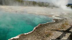
West Thumb Geyser Basin
Grant Visitor's Center, Yellowstone National Park
1.8 miles NW of Grant Visitor's Center, Yellowstone National ParkWest Thumb Geyser Basin is one of the smaller geyser basins in Yellowstone, yet its location along the shore of Yellowstone Lake and is ranked as the most scenic. This area was formed by volcanic...
Hike 5.6-8.3 mi
Palisades Creek Trail / Lakes and Waterfall Canyon
Irwin, Idaho
4.4 miles E of Irwin, IdahoPalisades Creek Trail is located about 50 miles southeast of Idaho Falls and about 60 miles west of Jackson Hole WY in Swan Valley Idaho. The four mile hike up to lower Palisades Lake or the 6.2 mile...
Backpack, Camp, Hike, Horseback, Mountain Bike


