


Bear Gulch
Ashton, Idaho

| Address: | Near Mesa Falls,Ashton, ID 83420, USA |
| GPS: |
44°9'4.1"N 111°17'11.2"W Maps | Directions |
| State: | Idaho |
| Trails/Routes: | 0.3-0.6 mi |
Camp, Cross Country Ski, Hike, and Sled
Bear Gulch is an abandoned ski hill out of operation since 1969.
While the vegetation is beginning to take over, there's still some great sledding to be had. It's just far enough into the hills that there's plenty of snow all through the winter and often from Fall to Spring. The most popular sledding run is on one of the overgrown ski runs. Starting above the parking lot it goes down through a "no motorized vehicles" gate and on down to the creek and old ski lift. Most people stick to the upper portion, especially with smaller children. However, there are a range of heights to start from so there really is something for all ages. The lower portion is faster and windy with usually a decent enough trail cut out that it guides you through every twist and turn all the way to the bottom. Being able to turn isn't essential but you may feel like slowing down or even stopping. Just be careful not to stop in front of somebody else. The hike up is pretty long and a little steep. Be sure to stay out of the way of other sledders coming down.
More Information
Bear Gulch Ski Basin | Fremont County Historical Society
Bear Gulch was the second established ski resort in Idaho, Sun Valley being the first in 1936.
https://fremontcountyhistoricalsociety.org/articles/bear-gulch-ski-basinExplore More | Your Go To for Everything Eastern Idaho
Come and experience everything that Eastern Idaho has to offer! Yellowstone Teton Territory is a fantastic resource to help you explore more!
https://yellowstoneteton.com/Be courteous, informed, and prepared. Read trailhead guidelines, stay on the trail, and don't feed the wildlife.
Read More- Plan Ahead and Prepare
- Travel & camp on durable surfaces
- Dispose of waste properly
- Leave what you find
- Minimize campfire impacts
- Respect wildlife
- Be considerate of other visitors
Directions
From Ashton, Idaho
- Head east on ID-47 N/Main St toward S 6th StContinue to follow ID-47 NDestination will be on the left(11.9 mi)
Take the Mesa Falls Scenic Highway East out of Ashton. Bear Gulch will be on your left just 3.5 miles after crossing Warm River. The road is only plowed as far as Bear Gulch in the winter which makes it considerably easy to find and pretty easy to drive. The parking lot is a favorite for snowmobilers, sledders, and cross-country skiiers alike.
Not accessible from the North during the Winter.
idahodyer
2/17/18 10:25 pmnlrventures
7/13/17 12:18 pm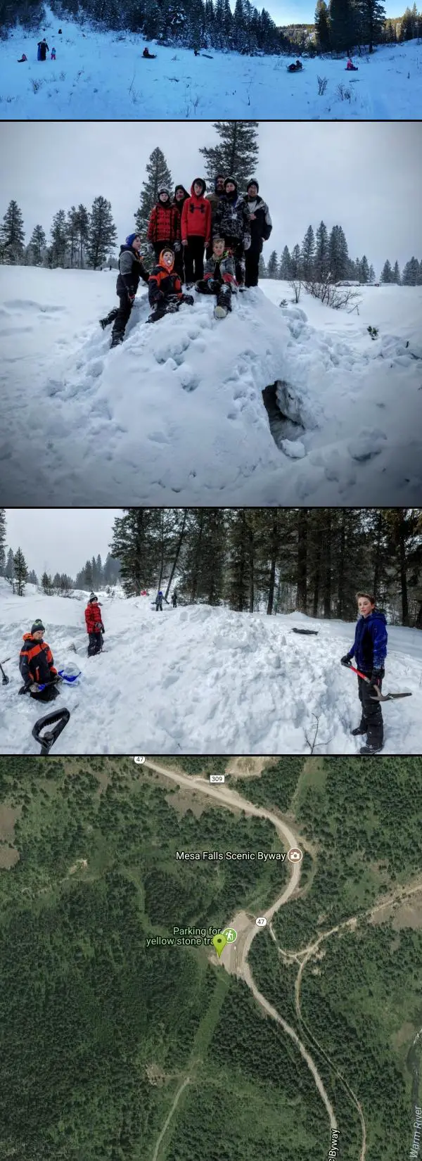


Other Hiking Trails, Cross Country Ski Trails, and Sledding Hills Nearby

Yellowstone Branch Line Trail
Ashton, Idaho
2.5 miles SWA 39-mile trail from Warm River to the Montana border — open to backpackers, hikers, mountain bikers, horseback riders, and ATVs through the Targhee National Forest.
Backpack, Cross-country Ski, Hike, Horseback, Mountain Bike
Mesa Falls
Ashton, Idaho
3.3 miles NWUpper Mesa Falls drops 114 feet and spans 300 feet across the Henrys Fork — just 0.2 miles of paved walkway from the parking lot, with platforms, handrails, and morning rainbow mist.
Cross-country Ski, Hike, Kayak
Sheep Falls on Henry's Fork
Island Park, Idaho
6.6 miles NWA 25-foot waterfall cascading through a narrow basalt chute on the North Fork of the Snake River — a pleasant, rarely crowded hike compared to nearby Mesa Falls.
Hike 17.5 mi
Tear Drop Lake
Ashton, Idaho
9.3 miles NEA small, lively lake in the Targhee forest for kayaking, swimming, and an easy loop trail — family fun with primitive lakeside camping.
Camp, Canoe, Hike, Kayak, Mountain Bike, Swim 0.8 mi
Conant Creek Pegram Truss Railroad Bridge
Ashton, Idaho
9.5 miles SWA spectacular converted railroad bridge with jaw-dropping views of Conant Creek hundreds of feet below — part of the 30-mile Ashton-Tetonia Trail, with vivid spring and fall colors and Teton backdrop.
Hike 14.8-15.1 mi
Mr. Bubbles Hot Spring
Old Faithful, Yellowstone National Park
11.9 miles EA remote 15-mile backcountry trek through Yellowstone's Bechler region to a rare wild soak fed by a thermal spring.
Hike, Hot Springs
Cave Falls of Yellowstone
Ashton, Idaho
14.3 miles EA campground right on the Fall River along Yellowstone's south boundary puts you steps from legendary fishing, with fire rings and bear-proof boxes at each site.
Camp, Hike 0.6-4.7 mi
Harriman State Park
Island Park, Idaho
14.6 miles NWAn 11,000-acre wildlife refuge 38 miles from Yellowstone along Henry's Fork — world-class fly-fishing, hiking among wildflowers and wildlife, plus 24 miles of Nordic ski trails in winter.
Cross-country Ski, Hike, Horseback, Mountain Bike, Snowshoe
Bitch Creek Trestle
Tetonia, Idaho
15.3 miles SEA Rails-to-Trails railroad bridge converted into an easy family viewpoint above Bitch Creek — part of the 30-mile Ashton-Tetonia Trail with more trestle adventures nearby.
Hike 15.9-16.6 mi
Union Falls & Ouzel Pool
Bechler Ranger Station, Yellowstone National Park
17.1 miles EA ~16-mile backcountry trek into Yellowstone's remote Bechler region rewards you with a 250-foot waterfall and Ouzel Pool — a warm-spring-fed swimming hole you can jump into.
Backpack, Hike, Hot Springs, Swim 1.1 mi
Fish Lake
Ashton, Idaho
17.1 miles EHike near Ashton, Idaho
Hike 2.9 mi
Box Canyon Trail
Island Park, Idaho
18.9 miles NA scenic 3-mile riverside singletrack along Henry's Fork in Box Canyon — open to OHVs under 50 inches wide, with river views most of the trail and great trout fishing.
Hike, Mountain Bike 1.9 mi
Terraced Falls
Grant Village, Yellowstone National Park
21.8 miles EAn easy 3.6-mile out-and-back hike to a tiered waterfall along the southern Yellowstone border — the trailhead is on the Ashton-Flagg Ranch Road, which closes in winter.
Hike
Big Springs
Island Park, Idaho
24.0 miles NA Big Springs campground shaded by Lodgepole Pines on Henry's Fork — with a 1-mile interpretive trail, fish feeding under the bridge, the historic Johnny Sack Cabin, and access to the Mesa Falls Scenic Byway.
Camp, Hike
Henry's Fork Green Way (St. Anthony Green Belt)
Saint Anthony, Idaho
24.0 miles SWAn easy paved 2-mile round-trip riverside walk along Henry's Fork in Saint Anthony — a statue of fur trader Andrew Henry at the halfway loop, and a pet-friendly, beginner-friendly path.
Hike 0.6 mi
Packsaddle Lake
Tetonia, Idaho
26.2 miles SA secluded, steep-access Teton lake with a 300-foot descent from the trailhead, water that drops off quickly at the edge, and a small camp on the eastern shore.
Dive, Hike, Mountain Bike, Snowshoe, Swim
St. Anthony Sand Dunes
Saint Anthony, Idaho
26.5 miles WWinter transforms the St. Anthony Sand Dunes into the smoothest sledding surface around — hills in every direction, bowl features, and halfpipe-like terrain on mountains of snow-covered sand.
Sled
Pine Butte / The Caldera
St. Anthony, Idaho
27.6 miles WAn old volcano in the Idaho desert that feels like stepping into a mountain forest — pine-covered hillsides, a meadow ringed by aspen and boulders, and a quarter-mile easy trail to the caldera floor.
Camp, Hike, Horseback 7.6 mi
Mount Jefferson
Island Park, Idaho
28.9 miles NIdaho's highest point in the Centennial Mountains crowns a remote 10,203-ft Continental Divide summit on the Idaho-Montana border west of Yellowstone.
Hike 4.2 mi
Lake Marie
Island Park, Idaho
28.9 miles NA high Continental Divide hike across the Idaho-Montana border to a cold, snowmelt-fed lake in a wildflower meadow — water level shifts dramatically from spring to fall.
Backpack, HikeNearby Campsites

Warm River Campground
Ashton, Idaho
2.4 miles SWSlow-moving warm water and willow-lined banks make this campground a perfect spot for tubing, trout fishing, and peaceful mountain biking at 5,200 ft elevation.
Camp
Porcupine Creek
Ashton, Idaho
5.5 miles SEA backcountry hunting, fishing, camping, and swimming spot in Targhee National Forest, surrounded by forests, meadows, a creek, and unmarked trails — bear country, so pack and store food carefully.
Camp, Swim
Horseshoe Lake
Ashton, Idaho
9.2 miles EA lily-pad-dotted lake hidden in the Targhee National Forest with a gradual beach entry perfect for wading, a floating dock for jumping, and no motorized boats.
Camp, Canoe, Dive, Swim 17.5 mi
Tear Drop Lake
Ashton, Idaho
9.3 miles NEA small, lively lake in the Targhee forest for kayaking, swimming, and an easy loop trail — family fun with primitive lakeside camping.
Camp, Canoe, Hike, Kayak, Mountain Bike, Swim
Sheep Falls on Fall River
Ashton, Idaho
10.9 miles SEA local gem off Cave Falls Road where the river splits into multiple falls tumbling over each other — primitive campsites and beautiful views make it a great picnic stop.
Camp
Cave Falls of Yellowstone
Ashton, Idaho
14.3 miles EA campground right on the Fall River along Yellowstone's south boundary puts you steps from legendary fishing, with fire rings and bear-proof boxes at each site.
Camp, Hike
Loon Lake
Ashton, Idaho
16.9 miles ECamp, Kayak, and Swim near Ashton, Idaho
Camp, Kayak, Swim 0.9 mi
Buffalo River Campground
Island Park, Idaho
19.5 miles NAn easy, clear, and often warm float on the Buffalo River near Island Park, with slow enough current to paddle back upstream in a canoe or kayak after your run.
Camp, Canoe, Kayak, Swim
Upper Coffee Pot Campground
Island Park, Idaho
23.8 miles NHenry's Fork of the Snake River winds through a lodgepole pine forest past this campground, offering fly-fishing for rainbow and brook trout and easy tubing and canoeing.
Camp, Canoe
Big Springs
Island Park, Idaho
24.0 miles NA Big Springs campground shaded by Lodgepole Pines on Henry's Fork — with a 1-mile interpretive trail, fish feeding under the bridge, the historic Johnny Sack Cabin, and access to the Mesa Falls Scenic Byway.
Camp, Hike
Pine Butte / The Caldera
St. Anthony, Idaho
27.6 miles WAn old volcano in the Idaho desert that feels like stepping into a mountain forest — pine-covered hillsides, a meadow ringed by aspen and boulders, and a quarter-mile easy trail to the caldera floor.
Camp, Hike, Horseback 14.8 mi
Biscuit Basin to Fairy Falls and Firehole Meadows
Old Faithful, Yellowstone National Park
29.0 miles NEA nearly 15-mile backcountry hike starting at Biscuit Basin passes turquoise pools, a 70-foot waterfall, Firehole Meadows, Imperial Geyser, and three stunning blue lakes with rust-red shores.
Backpack, Camp, Hike
Reunion Flat Campground
Alta, Wyoming
31.9 miles SECamp near Alta, Wyoming
Camp
Teton Canyon Campground
Alta, Wyoming
32.9 miles SETeton Canyon Campground is the gateway to Alaska Basin, Table Rock, and the Teton Crest Trail — each site stocked with a picnic table, fire ring, and bear box.
Camp 3.8-6.4 mi
Table Rock / Table Mountain
Driggs, Idaho
32.9 miles SEA big climb to 11,300 feet for arguably the finest view of the Grand Tetons — pick the steep Face or the gradual Huckleberry trail.
Camp, Hike 0.2-0.5 mi
Eagle Park
Rexburg, Idaho
33.5 miles SWA cottonwood forest park inside Rexburg city limits with campsites, fishing, a dog park, mountain biking on easy and moderate loops, and rock-throwing by the river.
Camp, Hike, Mountain Bike, Sled
Moody Meadows
Driggs, Idaho
33.7 miles SGood place for kids, they can ride bikes in the meadow, play in the stream, and camping is off of the road. Hiking, motorbiking, and horseback riding trails are abundant in the area.
Camp 0.1 mi
Lewis Lake Campground
Grant Village, Yellowstone National Park
33.8 miles EYellowstone's third-largest lake draws canoeists, kayakers, and serious anglers, with a quiet campground open mid-June through early November on a first-come basis.
Camp, Canoe, Kayak 0.8-1.3 mi
Warm Slough Campground
Rexburg, Idaho
34.8 miles SWA popular river campground with two boat ramps and an easy, slow-moving inner tube float — the take-out is 1,000 feet from the put-in, making multiple runs a breeze.
Airsoft, Camp, Canoe 0.5-3.5 mi
Webster's Dam
Ririe, Idaho
35.0 miles SWAn abandoned dam in Moody Creek canyon where sediment split the stream into two beautiful 15-foot waterfalls — stunning in spring runoff and blazing with fall colors.
Camp, Hike, Mountain Bike


