


Au Train Beach
Au Train

Canoe, Kayak, and Swim
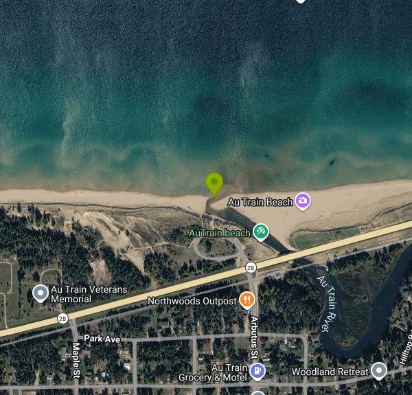
Au Train Beach is the Lake Superior beach at Au Train Beach Roadside Park, a Michigan Department of Transportation (MDOT) roadside park on M-28 in the village of Au Train, Alger County. The Au Train River runs along the back of the sand, parallel to the shore, then turns north and empties into Au Train Bay right at the park. That puts two kinds of water a few steps apart: the shallow river outlet and the open bay. Munising is about 8 miles east.
Drive M-28 to the yellow flashing light in Au Train, where Au Train-Forest Lake Road meets the highway. The park sits on the lake side of M-28 just west of the river bridge, with two small parking lots and toilets a short walk from the sand. MDOT roadside parks don't charge for entry, and no fee or pass is posted for this one. The park is seasonal. It usually opens in late April or May once the snow clears and closes for winter in late October.
The beach is soft sand backed by low dunes, with a sandy bottom. Lake Superior stays cold here even in August, so a lot of people end up in the river instead. It warms much faster than the lake and is shallow enough near the mouth to wade, float and splash in. The sandbars at the mouth shift from year to year, and so does the depth. There are no lifeguards, no roped swim area and no water quality sampling at this beach.
Look at the lake before you go in. River current meeting the lake can pull swimmers sideways, and a north wind builds surf and rip currents along this shore fast. On rough days, stay in the river or on the sand. Don't dig into the dune banks either. Sand banks along this shore have collapsed on children digging into them. MDOT closes the park for short stretches for maintenance work.
Sand and ice building up at the river mouth can back the Au Train up and flood the low ground upstream, and the Army Corps of Engineers and the state have been studying the problem along with work at the Forest Lake Dam.
The Au Train is a popular flatwater canoe and kayak river with clear, root-beer colored water. Paddlers usually take out at the Au Train Heritage Landing, an accessible floating launch by the trail bridge just upstream of M-28, or keep going under the highway to the lake. An ORV and snowmobile trail crosses the river beside the park. Scott Falls, another MDOT roadside park, is a short drive east on M-28, and Au Train Island sits out in the bay.
More Information

- Plan Ahead and Prepare
- Travel & camp on durable surfaces
- Dispose of waste properly
- Leave what you find
- Minimize campfire impacts
- Respect wildlife
- Be considerate of other visitors
Directions
From Au Train
- Head north on Arbutus St/
Autrain Forest Lake Rd toward Park Ave (0.2 mi) - Continue straightDestination will be on the right(417 ft)


Other Swimming Holes, Canoeing Areas, and Kayaking Areas Nearby
Pictured Rocks
Shingleton, Michigan
14.9 miles EA beautiful, little-used beach framed by the Pictured Rocks in Lake Superior's Pictured Rocks National Lakeshore — bathing suits may be optional.
Swim
South Beach Park
Marquette
27.0 miles WA free city beach at the south end of the Marquette waterfront, where a rock break wall and a long shallow sandy shelf make Lake Superior swimmable earlier in the summer than anywhere else in town.
Kayak, Swim
Clark Lambros Beach Park
Marquette
28.0 miles WA free, lifeguarded city beach on Lake Superior just north of downtown Marquette, with soft sand, restrooms and an accessible kayak launch on the Dead River.
Canoe, Kayak, Swim
Farquar Metsa Park
Gwinn, Michigan
30.5 miles WSwim near Gwinn, Michigan
Swim
Hurricane River Beach (Pictured Rocks)
Grand Marais, Michigan
35.8 miles NELake Superior beach where the Hurricane River comes out at Pictured Rocks, with a 22-site campground on the bluff, shipwreck timbers in the sand and the Au Sable Light a mile and a half east.
Camp, Hike, Swim
Teal Lake Public Beach
Negaunee
37.1 miles WA small free city beach on Teal Lake at the end of Croix Street in Negaunee, with cold clear water, a quick drop-off and an ADA ramp and beach mat down to the shallows. Swimming was banned here until 1995, when the lake stopped being the town's drinking s
Canoe, Hike, Kayak, Swim
Sable Falls Beach
Grand Marais, Michigan
42.4 miles NELake Superior beach where Sable Creek reaches the lake below 75-foot Sable Falls, at the east end of Pictured Rocks National Lakeshore a mile from Grand Marais.
Hike, Swim


