


Desert Trails Bike Park
Mesa, Arizona

| Address: | Desert Trails Bike Park, 2801, 3057 N Recker Rd, Mesa, AZ 85215, United States |
| GPS: |
33°28'9.6"N 111°42'4.3"W Maps | Directions |
| State: | Arizona |
Hike and Mountain Bike
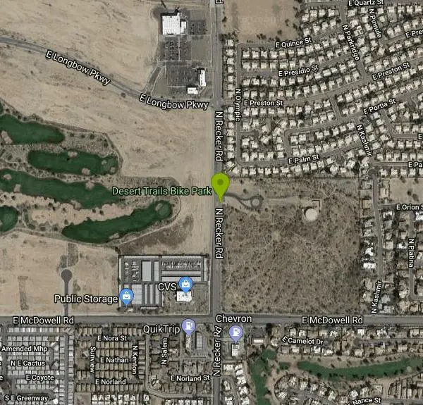
Desert Trails Park is a purpose-built mountain-bike and skills park on the northeast corner of McDowell and Recker roads in Mesa, Arizona. Opened in 2014 as one of the city's newest parks, its roughly 35 acres of Sonoran desert were shaped into a progression-focused riding area built in large part by volunteers from the Gravity Riders Organization of Arizona (GROAZ).
The centerpiece is a set of three gravity flow trails that share a common start and drop down the park's low hill, color-graded like a ski run: the green-rated Runaway Train for beginners, the blue-rated Squirrel Catcher for intermediate riders, and the black-rated Double Trouble for experts, the last stacked with jumps, drops and tight bermed corners. A dirt pump track and a smaller kids' skills track let newer and younger riders build bike handling in a lower-consequence setting, and cross-country trails wind through the surrounding desert.
Amenities are simple but real: two ramadas, restrooms and a parking lot on the Recker Road side. Because it is unlit natural-surface terrain, the park is open sunrise to sunset and closes when it rains or the dirt is muddy, both to protect the trails and because the clay-heavy soil turns slick and unrideable when wet. Shade is minimal and summer temperatures are extreme, so most riders come in the cooler months or early on summer mornings. It is a popular spot for local families, beginners learning to ride, and experienced riders lapping the flow lines after work.
More Information
Desert Trails Park
On the northeast corner of McDowell and Recker.
https://www.mesaaz.gov/Activities-Culture/Parks-Recreation-and-Community-Facilities/Parks-Facilities/Desert-Trails-ParkDesert Trails Park | Visit Mesa
Desert Trails Park is 35 acres and includes a series of hiking and biking trails, a pump track, a kids’ skills track, two ramadas, a restroom, and a 30-spot
https://www.visitmesa.com/directory/desert-trails-park/Never modify trail features. Ride trails when they're dry enough that you won't leave ruts. Speak up when you see others on the trail and always yield to hikers, horses, and others coming uphill. Always ride on the established trail.
Read MoreBe courteous, informed, and prepared. Read trailhead guidelines, stay on the trail, and don't feed the wildlife.
Read More
- Plan Ahead and Prepare
- Travel & camp on durable surfaces
- Dispose of waste properly
- Leave what you find
- Minimize campfire impacts
- Respect wildlife
- Be considerate of other visitors
Directions
From Mesa, Arizona
- Head east on W Main St toward S MacDonald (486 ft)
- Turn left onto N Macdonald (0.5 mi)
- Turn left onto W University DrPass by Money Mart (on the right in 0.3 mi)(0.3 mi)
- Turn right onto N Country Club Dr (2.2 mi)
- Turn right to merge onto AZ-202 Loop E (7.4 mi)
- Take exit 21 for Higley Rd (0.5 mi)
- Turn right onto N Higley Rd (1.0 mi)
- Turn left onto E McDowell Rd (1.0 mi)
- Turn left onto N Recker RdDestination will be on the right(0.2 mi)
Bike trails, pump track, and skills track are closed when it is raining and when the trails are muddy. Please stay off of the trails when the ground is wet enough to allow the dirt to stick to your shoes or wheels.
Desert Trails Park opened in November, 2014. The Park includes:
- 37.09 acres
- A series of trails, a pump track and kids' skills track
- Two shaded picnic ramadas (non-reservable)
- Picnic Tables
- Restroom facilities
- 30-spot parking lot
Hours are sunrise to sunset
Courtesy of mesaparks.com

Other Mountain Bike Trails and Hiking Trails Nearby

Hawe's Loop
Mesa, Arizona
2.7 miles NTwisting desert singletrack near Mesa with great flow, views of Red Mountain and the Salt River, and optional reverse laps for a serious endurance climb.
Hike, Mountain Bike 1.5 mi
The Saddle
Mesa, Arizona
2.8 miles NAn intermediate mountain bike trail with views of the Salt River and Red Mountain, connecting to the greater Hawes trail network via scenic singletrack.
Hike, Mountain Bike 1.3 mi
Ridge Trail
Mesa, Arizona
2.8 miles NA 2-mile intermediate descent with tight, twisty turns and loose desert dirt — ride back up for 2 miles of easy climbing in the heart of the Hawes loop system.
Mountain Bike 
East Maricopa Floodway
Mesa, Arizona
3.9 miles SA flat, pebble-and-tar floodway connecting miles of easy cycling from Main Street and Higley Road all the way to Roosevelt Canal — a quiet, car-free route through Mesa.
Mountain Bike 
Buckhorn Campground Nature Trail
Apache Junction, Arizona
4.7 miles ECamp and Hike near Apache Junction, Arizona
Camp, Hike 1.7 mi
Levee Trail
Mesa, Arizona
4.9 miles EA smooth, flat double-track trail inside Usery Mountain Regional Park running parallel to a channel — an ideal cross-country ride, run, or connector for longer loops.
Hike, Horseback, Mountain Bike 1.5 mi
Moon Rock Loop
Apache Junction, Arizona
5.0 miles EA fast, mostly-downhill 1.3-mile doubletrack loop with smooth pavement-like surface and flowy turns inside Usery Mountain Regional Park — accessible via the Blevins Trail.
Hike, Horseback, Mountain Bike 
Usery Mountain Regional Park
Mesa, Arizona
5.1 miles EMiles of two-way singletrack at multiple difficulty levels in Mesa, from beginner-friendly washes to the challenging Pass Mountain Trail — bring water, especially in summer heat.
Mountain Bike 
Crismon Wash Trail
Mesa, Arizona
5.1 miles EA 1.8-mile wash trail in Mesa, Arizona accessible from the Crismon Road trailhead or the Blevins Trail — part of a network that supports several loop configurations through desert terrain.
Hike, Horseback, Mountain Bike 
Pass Mountain
Mesa, Arizona
5.2 miles EMultiple loop options from beginner-friendly Moonrock and Blevins trails to the demanding Pass Mountain and Cat Peaks loops — a versatile desert MTB system for all levels.
Mountain Bike 
Cat Peaks - Blevin - Moonrock
Apache Junction, Arizona
5.4 miles EA linked trail system combining Blevins, Moonrock, and Cat Peaks loops for a mix of flowy singletrack, technical climbs, and steep descents near Apache Junction.
Mountain Bike 2.1 mi
Lower Salt River Nature Trail
Fort McDowell, Arizona
5.7 miles NEA 2-mile beginner loop alongside the Salt River in Tonto National Forest, with worn markers that keep things adventurous — watch for wild horses and spring cactus blooms.
Camp, Hike 
Blevins Via Meridian
Apache Junction, Arizona
7.0 miles EA one-mile intermediate-to-beginner mountain bike ride down Meridian Trail near Apache Junction with dry wash crossings and beautiful views — linking to the Blevins Trail for more adventure.
Mountain Bike 
Cat Peaks Via Ruidoso
Apache Junction, Arizona
7.1 miles EA beginner-to-intermediate mountain bike loop from Ruidoso through Cat Peaks Pass with dry wash crossings, rock barriers, and a fun descent down the back side near Apache Junction.
Mountain Bike 
Riparian Preserve at Water Ranch Trail
Gilbert, Arizona
7.5 miles SAn urban loop trail system surrounding seven ponds stocked with fish and birds near Gilbert — a great spot for birding, wildlife watching, and easy walking.
Canoe, Hike 
Fountain Hills Park
Fountain Hills, Arizona
9.2 miles NA 1.3-mile loop trail at Fountain Hills Park near Phoenix accessible year-round for all skill levels — a pleasant hike through a well-known community park.
Hike 
Prospector Loop
Apache Junction, Arizona
9.4 miles EA fast beginner-to-intermediate desert training loop over undeveloped gravel terrain — easy to navigate by following powerlines or the park to the south, no technical challenges.
Mountain Bike 
Fountain Park Trail
Fountain Hills, Arizona
9.5 miles NA well-groomed ridge trail in Fountain Hills with Fountain Park views to the west and Four Peaks to the northeast — great for family hikes.
Hike, Mountain Bike 
Sunrise Peak via Sunrise Trail
Scottsdale, Arizona
9.6 miles NWSunrise Peak is one of the most rewarding summit hikes in the McDowell Sonoran Preserve, the vast protected desert straddling the McDowell Mountains northeast of Scottsdale and north of Fountain...
Hike 
Sunrise
Scottsdale, Arizona
11.1 miles NWA sweet little loop trail in Scottsdale with a gradual climb, fun descent, and nice views of Scottsdale and Phoenix — watch out for cacti and bring plenty of water on this exposed, sun-baked ride.
Mountain BikeNearby Campsites
Buckhorn Campground Nature Trail
Apache Junction, Arizona
4.7 miles ECamp and Hike near Apache Junction, Arizona
Camp, Hike 2.1 mi
Lower Salt River Nature Trail
Fort McDowell, Arizona
5.7 miles NEA 2-mile beginner loop alongside the Salt River in Tonto National Forest, with worn markers that keep things adventurous — watch for wild horses and spring cactus blooms.
Camp, Hike


