


84 Hiking Trails near Verde Hot Springs
first prev 1 2 3 4 5 next lastShowing Hiking Trails within 50 miles Distance miles of Child's Power Rd, Arizona, USA City, Zip, or Address

Haigler Canyon Campground
Payson, Arizona
42.9 miles EThis campground was constructed in 2007 and offers 2 day-use sites and 2 campground areas with 14 overnight sites. This campground boasts a diversity of trees. Fishing for rainbow trout is a popular...
Camp, Hike, Swim 4.0 mi
Woods Canyon Lake
Payson, Arizona
42.9 miles EWoods Canyon Lake is a fishing lake near Payson, Arizona located near the Mogollon Rim. The lake has a hike that loops around it, and several other hikes nearby to look at the particularly scenic...
Camp, Hike, Swim 3.3 mi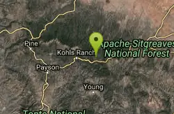
Meadow Trail #505
Payson, Arizona
43.0 miles EMeadow Trail #505 is a paved path that leads from the edge of Woods Canyon Lake to the scenic edge of the Woods Canyon vista. This hike is smooth enough to allow for easy access by wheelchairs,...
Hike
Pinnacle Peak Trail
Scottsdale, Arizona
43.9 miles SPinnacle Peak is a 3.5 mile out-and-back, moderate hiking trail, that includes rock climbing routes (for experienced climbers), within the Sonoran Desert. This trail, and park, in...
Hike, Horseback, Rock Climb 5.4 mi
Denton Trail #69
Tonto Basin, Arizona
43.9 miles SEFrom FR 421, the trail climbs steadily up the east face of the mountain. Some sections are quite steep. The trail eventually tops out at 5,760 feet elevation and then descends to Big Pine Flat for...
Hike, Mountain Bike
Tower Road - Sonoran Preserve
Phoenix, Arizona
43.9 miles SWShort and steep (.6 mile each way) out and back asphalt road to the radio tower.
Hike
Sidewinder-Ocotillo-West Loop
Phoenix, Arizona
43.9 miles SWThis loop starts at Carefree Hwy and 7th Ave, be aware there is limited parking at the trailhead. The Ocotillo part of the trail is relatively flat and the Sidewinder part has some good...
Hike, Horseback, Mountain Bike 0.1-7.8 mi
Wolf Creek Falls
Sedona, Arizona
44.5 miles WWolf Creek Falls is a wonderful space to explore and be immersed in nature. With it's six miles of trails, beautiful waterfalls and two campgrounds this is the perfect place to spend a...
Camp, Hike, Swim
Ocotillo/Ridgeback/Sidewinder Loop Trail
Phoenix, Arizona
44.7 miles SWGreat moderate loop which includes a summit, great views and Classic Sonoran Desert scenery. Multiple access points and other connecting trails allows for the loop to be changed if...
Hike, Horseback, Mountain Bike

Sidewinder, Apache Vista, Ocotillo Loop Trail
Phoenix, Arizona
44.8 miles SWThis is an excellent loop that is very well maintained, well sign posted and if you include the vista summit trail, a moderate work out. Massive Car Park, good restrooms, and plenty of...
Hike, Horseback, Mountain Bike 0.1-0.7 mi
Cave Springs
Sedona, Arizona
44.8 miles NCave Springs Campground is a scenic campground that sits in Oak Creek Canyon. Cave Springs is nestled perfectly in the town of Sedona, giving the campground the notorious Sedona red views. Uniquely,...
Camp, Hike, Swim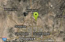
Apache Wash Trail
Phoenix, Arizona
45.1 miles SWStart west on Ocitillo to Ridgeback north till you get to the crossing of Sidewinder then head west. Keep on Sidewinder toil you come to the crossing of Octillio and head east back to...
Hike 1.0 mi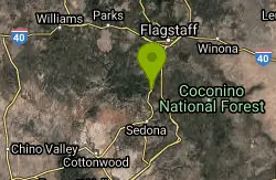
Harding Springs Trail
Sedona, Arizona
45.1 miles NHarding Springs Trail is a beautiful hiking trail in Sedona, Arizona. This trail was originally one of several that provided a way for cattlemen to drive their stock in and out of Oak Creek...
Hike
Wagner Trail
Scottsdale, Arizona
45.2 miles SWagner Trail is a 2.2 mile, beginner to intermediate loop trail located in the McDowell Sonoran Preserve. The trail is well-marked and easy to follow; this wide, but rugged...
Hike, Horseback, Mountain Bike
Wagner-Granite-Bluff Trails
Scottsdale, Arizona
45.2 miles SHike and Mountain Bike near Scottsdale, Arizona
Hike, Mountain Bike
Tortoise and Hilltop Trails
Fort McDowell, Arizona
45.3 miles SBe on the lookout for wildlife like jackrabbits and lizards on the initial stretch of trail (Tortoise Trail) and for mountain bikers as this trail joins the Pemberton Trail for a bit as...
Hike 2.2 mi
Marcus Landslide Trail
Scottsdale, Arizona
45.5 miles SThe Marcus Landslide Trail is named after ASU professor Melvin Marcus, a renouned geographer, after the discovery and recognition of the interesting geographical area in 2002. More than 500,000...
Hike, Horseback, Mountain Bike, Rock Climb
Tom's Thumb Trail
Scottsdale, Arizona
45.5 miles STom's Thumb Trail is a popular trail on the McDowell Sonoran Preserve due to its unique thumb-like granite rock formation. This is a 4.7 out-and-back, intermediate trail because of its 1,200...
Hike, Mountain Bike, Rock Climb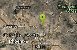
Tom's Thumb, Feldspar, and Marcus Landslide Loop
Scottsdale, Arizona
45.6 miles SHike near Scottsdale, Arizona
Hike
Bobcat Trail - Sonoran Preserve
Phoenix, Arizona
46.2 miles SWBobcat Trail is a short, easy trail, often used for connecting to other bigger trails in the Sonoran Desert Preserve. This is a 2 mile out-and back trail. There isn't much of a parking...
Hike


