


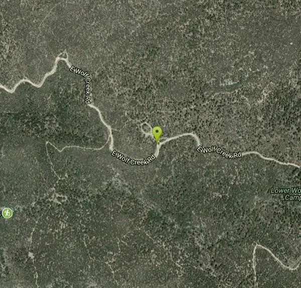
Wolf Creek Falls
Sedona, Arizona

| GPS: |
34°27'24.4"N 112°28'4.6"W Maps | Directions |
| State: | Arizona |
| Trails/Routes: | 0.1-7.8 mi |
Camp, Hike, and Swim
Wolf Creek Falls is a wonderful space to explore and be immersed in nature. With it's six miles of trails, beautiful waterfalls and two campgrounds this is the perfect place to spend a weekend enjoying the great outdoors.
Wolf Creek Falls itself has a variety of appearances throughout the year. In the winter the waterfall can sometimes be seen as a frozen cascade over the granite rocks. In the summer the roaring waterfall slows to a small trickle. In the spring and fall, during big rainstorms the waterfall is a magnificent 90 foot tall rush.
The hike to the waterfall is a short out and back hike from the Lower Falls Campground. The hike is a little less than a mile out and back, and is easy for all levels of hikers. When the waterfall is at full flow there are several spots where the water is deep enough for swimming.
Those who are looking for a longer, more intense hike can enjoy hiking the entire Wolf Creek Loop Trail #384. This trail is a 5.5 mile loop, that also passes Wolf Creek Falls. This trail can be started at either the Lower Falls or Upper Falls Campgrounds.
Mapped Route/Trail Distances
| Route to Waterfall | 272 feet |
| Wolf Creek Falls | 0.8 miles |
| Wolf Creek Loop Trail #384 | 7.8 miles |
More Information
Be courteous, informed, and prepared. Read trailhead guidelines, stay on the trail, and don't feed the wildlife.
Read More- Plan Ahead and Prepare
- Travel & camp on durable surfaces
- Dispose of waste properly
- Leave what you find
- Minimize campfire impacts
- Respect wildlife
- Be considerate of other visitors
Directions
From Sedona, Arizona
- Head south on N State Rte 89A toward Forest Rd (0.3 mi)
- At the traffic circle, take the 3rd exit onto AZ-179 SGo through 1 traffic circle(0.9 mi)
- At the traffic circle, continue straight to stay on AZ-179 S (0.6 mi)
- At the traffic circle, continue straight to stay on AZ-179 S (1.4 mi)
- At the traffic circle, continue straight to stay on AZ-179 S (0.5 mi)
- At the traffic circle, continue straight to stay on AZ-179 S (3.0 mi)
- At the traffic circle, continue straight to stay on AZ-179 S (0.6 mi)
- At the traffic circle, continue straight to stay on AZ-179 S (0.2 mi)
- At the traffic circle, continue straight to stay on AZ-179 S (0.3 mi)
- At the traffic circle, continue straight to stay on AZ-179 S (7.0 mi)
- Turn right to merge onto I-17 S toward Phoenix (20.3 mi)
- Take exit 278 for State Hwy 169 toward Prescott (0.3 mi)
- Turn right onto AZ-169 S/
State Hwy 169 S (15.0 mi) - Turn right onto AZ-69 N/
E State Rte 69 Pass by Starbucks (on the left in 14.0 mi)(15.0 mi) - Slight left onto AZ-69 N (0.2 mi)
- Slight right onto E Gurley St (0.6 mi)
- Continue straight to stay on E Gurley St (417 ft)
- Turn left onto S Mt Vernon Ave (0.4 mi)
- S Mt Vernon Ave turns slightly left and becomes S Senator Hwy (6.8 mi)
- Turn right onto E Wolf Creek RdDestination will be on the right(1.6 mi)


Trails
Distance ?
272 feetElevation Gain ?
30 feetReal Ascent ?
30 feetReal Descent ?
0 feetAvg Grade (6°)
11%Grade (6° to 6°)
11% to 11%Distance ?
0.8 milesElevation Gain ?
-334 feetReal Ascent ?
0 feetReal Descent ?
334 feetAvg Grade (-4°)
-8%Grade (-6° to -3°)
-11% to -5%Distance ?
7.8 milesReal Ascent ?
1,116 feetReal Descent ?
1,096 feetGrade (-10° to 11°)
-18% to 20%Elevation differences are scaled for emphasis. While the numbers are accurate, the cut-away shown here is not to scale.
Other Swimming Holes and Hiking Trails Nearby
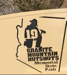
Granite Mountain Hotshots Memorial
Yarnell, Arizona
24.8 miles SWFrom the Observation Deck, you can see the Fatality Site 400’ below and the Town of Yarnell to the east. Additional interpretive signage outlines the tragic events of the Yarnell Hill Fire. A...
Hike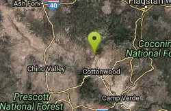
Sycamore Canyon
Sedona, Arizona
37.0 miles NEA very pleasant 3.5 mile round trip hike down into a canyon and along a perennial stream to several swimming holes. Bathing suits: May be optional at farther...
Swim 0.1 mi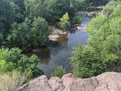
Mormons Crossing
Cornville, Arizona
38.1 miles NEMormons Crossing is a little area along Oak Creek in Cornville, Arizona. Along this creek there are several holes deep enough to swim in, some rapids, and even a rope swing. It's a great spot to...
Swim 0.4 mi
Clear Creek Campground
Camp Verde, Arizona
40.1 miles EWest Clear Creek flows along the boundary of this desert canyon country camp and is a popular place for hiking, swimming, wading and fishing. Cool water species such as smallmouth bass and green...
Camp, Hike, Swim 16.9 mi
West Clear Creek Trail No. 17
Camp Verde, Arizona
43.7 miles EWest Clear Creek Trail No. 17 is a great way to reach the running waters of West Clear Creek. By far the most accessible and popular, it starts from the Bull Pen Ranch parking lot and winds down the...
Backpack, Hike, Swim
Bullpen Day Use Area
Camp Verde, Arizona
43.7 miles EBullpen has something for everyone. Whether you park here and use the trail head to start on one of several hikes that lead down West Clear Creek, or stay nearby to use the picnic areas and...
Backpack, Dive, Hike, Swim 3.0 miBlodgett Basin Trail No. 31
Camp Verde, Arizona
43.8 miles EBlodgett Basin Trail is one of a select few trails that shows off the riparian desert beauty unique to West Clear Creek Wilderness. The trail stretches from Bull Pen Trailhead through the canyon and...
Backpack, Hike, Swim
Verde Hot Springs
Camp Verde, Arizona
44.6 miles EVerde Hot Springs are a few natural hot spring pools located along the Verde River, near Sedona, Arizona. Once a resort, now all that remains are the foundations and the hot pools...
Camp, Hike, Hot Springs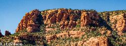
Red Rock State Park
Sedona, Arizona
45.3 miles NERed Rock in Sedona, Arizona details the beauty in the layers of sedimentary rock that has been constructed over millions of years. It is at Red Rock that you can see "Schnebly Hill...
Hike, Swim
Beaver Creek Campground
Camp Verde, Arizona
45.4 miles ECamp, Canoe, Kayak, and Swim near Camp Verde, Arizona
Camp, Canoe, Kayak, Swim 7.1 mi
The Crack at Wet Beaver Creek
Rimrock, Arizona
45.4 miles EThe Crack is a popular swimming hole found by hiking the Bell Trail down to Wet Beaver Creek. After following the trail for about 3.5 miles away from the parking lot, take a detour to the left just...
Dive, Hike, Horseback, Swim
Chavez Crossing
Sedona, Arizona
47.4 miles NEChavez Crossing is a campground in Sedona, Arizona. It sits perfectly nestled in Arizona's most beautiful red rock attractions along with the grand summer sunsets. If that didn't sound...
Camp, Hike, Swim 3.9 mi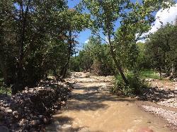
Cave Creek Swimming Hole
Cave Creek, Arizona
48.0 miles SEHidden along Cave Creek Trail #4 is a swimming hole deep enough to refresh from the summer heat. It takes almost four miles of hiking in Arizona desert to reach the swimming hole, but the water is...
Hike, Swim
Devil's Bridge
Sedona, Arizona
48.3 miles NEWe loved the red rock views on this hike! It's a 3.6 mile round-trip trail, on rocky/sandy ground, and is fairly easy, until the last mile, which is steep. Dozens of jeeps and ATVs passed us -...
Hike 1.1 mi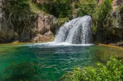
Fossil Creek Waterfall
Pine, Arizona
48.8 miles EFossil Creek is one of Arizona's two designated "Wild and Scenic" rivers. The waterfall is the most popular place to visit to cool off and see the natural beauty. Located between...
Hike, Swim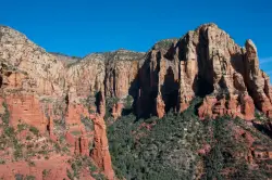
Brins Mesa Trail
Sedona, Arizona
49.1 miles NEBrins Mesa Trail is located in the Coconino National Forest just at the edge of the town of Sedona. This trail will provide picturesque views of the gorgeous, geological landscape. Brins...
Hike 6.0 mi
Huckaby Trail
Sedona, Arizona
49.6 miles NEOn the hunt for adventure? Established in 1998, Huckaby Trail is just the adventuresome route for both avid hikers and mountain bikers. It offers up forestry of Arizona Sycamores and picturesque...
Canoe, Hike, Mountain BikeNearby Campsites
Clear Creek Campground
Camp Verde, Arizona
40.1 miles EWest Clear Creek flows along the boundary of this desert canyon country camp and is a popular place for hiking, swimming, wading and fishing. Cool water species such as smallmouth bass and green...
Camp, Hike, Swim
Beaver Creek Dispersed Camping
44.5 miles E
Free dispersed camping on the cliffs above Beaver Creek.
Camp
Verde Hot Springs
Camp Verde, Arizona
44.6 miles EVerde Hot Springs are a few natural hot spring pools located along the Verde River, near Sedona, Arizona. Once a resort, now all that remains are the foundations and the hot pools...
Camp, Hike, Hot Springs
Beaver Creek Campground
Camp Verde, Arizona
45.4 miles ECamp, Canoe, Kayak, and Swim near Camp Verde, Arizona
Camp, Canoe, Kayak, Swim
Chavez Crossing
Sedona, Arizona
47.4 miles NEChavez Crossing is a campground in Sedona, Arizona. It sits perfectly nestled in Arizona's most beautiful red rock attractions along with the grand summer sunsets. If that didn't sound...
Camp, Hike, Swim


