


Horse Thief Canyon
Corona, California
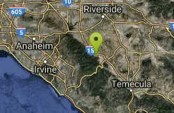
| Address: | Mountain Rd. Corona, CA 92883 |
| GPS: |
33°43'8.2"N 117°25'54.4"W Maps | Directions |
| State: | California |
Airsoft and Hike
Horse Thief Canyon is a hidden play location in Lake Elsinore/Corona, California. This is an Awesome place to play off of the side of the road. Rocks, Trees, Sandpits, and more to make your game just as entertaining as playing at a public park. As With all hidden locations, play responsibly and respect your surroundings.
Info Provided by airsoftspot.com
More Information
Add ResourceBe courteous, informed, and prepared. Read trailhead guidelines, stay on the trail, and don't feed the wildlife.
Read More
- Plan Ahead and Prepare
- Travel & camp on durable surfaces
- Dispose of waste properly
- Leave what you find
- Minimize campfire impacts
- Respect wildlife
- Be considerate of other visitors
Directions
From Corona, California
- Head east on E 6th St toward Ramona Ave (1.2 mi)
- Turn right onto El Sobrante Rd (0.6 mi)
- Turn left onto Magnolia Ave (272 ft)
- Turn right to merge onto I-15 S toward San Diego (9.6 mi)
- Take exit 85 for Indian Truck Trail (0.3 mi)
- Turn right onto Indian Truck Trail (0.1 mi)
- Turn left onto De Palma Rd (1.7 mi)
- Turn right onto Horse Thief Canyon Rd (1.4 mi)
- Turn right onto Mountain RdDestination will be on the left(138 ft)

Other Airsoft Fields and Hiking Trails Nearby
Lake Perris State Recreation Area
Moreno Valley
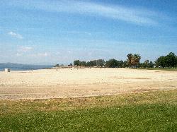
17.2 miles NETwo buoyed, lifeguarded swim beaches on the Lake Perris shore, at the southern end of the State Water Project between Moreno Valley and Perris. Day use is $10 per car, $20 on summer weekends.
Camp, Hike, Kayak, Swim
laguna lake park trail
Fullerton, California
31.8 miles NWA level loop trail around a 25-acre natural lake and open hillsides with views of the surrounding Morros in this 450-acre Fullerton park with deep Chumash history.
Hike
Dripping Springs Trail/Agua Tibia Wilderness
Temecula, California
31.8 miles SEA strenuous Agua Tibia Wilderness trail with immediate climbing, long switchbacks, and a high-elevation traverse — best in fall, winter, or spring; carry water and skip summer visits.
Hike
Arroyo Pescadero Park
Whittier, California
36.8 miles NWAn ADA-accessible interpretive trail and wildlife corridor connecting the Whittier Narrows to Cleveland National Forest through the Puente Hills — featuring decorative artist-designed gates and naturalist-focused signage.
Hike
Vivian Creek Trail
Forest Falls, California
39.7 miles NEThe shortest but steepest route to the Mt. San Gorgonio summit, gaining serious elevation in 1.2 miles to Vivian Creek Camp at 7,100 feet — a Forest Adventure Pass required.
Camp, Hike
Oak Grove/High Point Trail
Warner Springs, California
43.7 miles SEA steep but rewarding trail in the Palomar District near Warner Springs with great views of the San Jacinto and San Gorgonio Mountains and optional 5-mile extension to the High Point Lookout. Bring lots of water.
Hike, Mountain Bike
Apple Canyon via Devil's Slide (shuttle hike)
Mountain Center, California
44.8 miles EHike near Mountain Center, California
HikeNearby Campsites
Lake Perris State Recreation Area
Moreno Valley
17.2 miles NETwo buoyed, lifeguarded swim beaches on the Lake Perris shore, at the southern end of the State Water Project between Moreno Valley and Perris. Day use is $10 per car, $20 on summer weekends.
Camp, Hike, Kayak, Swim
Vivian Creek Trail
Forest Falls, California
39.7 miles NEThe shortest but steepest route to the Mt. San Gorgonio summit, gaining serious elevation in 1.2 miles to Vivian Creek Camp at 7,100 feet — a Forest Adventure Pass required.
Camp, Hike


