


Horton Springs
Payson, Arizona

| Address: | Zane Gray Hwy, Payson, AZ 85541, USA |
| GPS: |
34°20'23.7"N 111°5'44.0"W Maps | Directions |
| State: | Arizona |
| Trails/Routes: | 1.1-3.5 mi |
Waterfalls Streams Trails Wildflowers Fishing
Backpack, Camp, and Hike
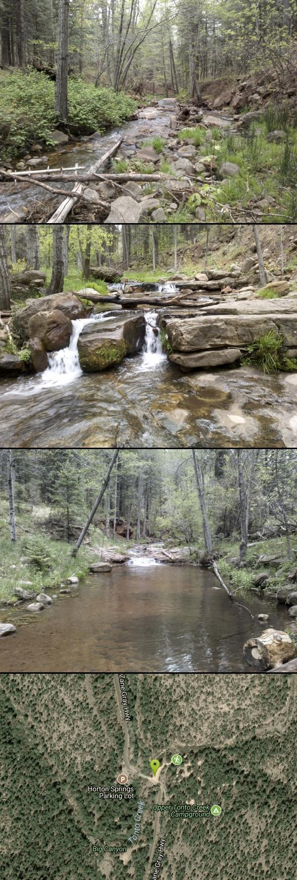
Horton Springs is a spring on the Mogollon Rim that leads into Horton Creek. There are campsites near the springs, and several hiking trails in the area that lead to the spring itself. Between the waterfalls, the wildflowers, and the many maples, this is a beautiful destination to hike year round, or to backpack and explore.
Horton Creek Trail is a popular, easy hike that leads directly to the springs. The trailhead is located near the Upper Tonto Creek Campground, and is often frequented, especially on the weekends. At some points, the trail overlaps with the creek bed, so be prepared for your feet to get wet! You won't be able to do much swimming, but there's plenty of water to splash around, and you can still enjoy the refreshingly cold creek. The trail ends at the Highline Trail, at which point the Springs are only a few yards away. The waterfall where the spring emerges from the mountain is a unique sight. There are some dispersed campsites located near the spring, allowing for a potential overnight stay.
The other trail to reach Horton Spring is Horton Springs Trail; This trail begins north of the spring, off of Rim Road (or FR 300) and takes a short but steep 1-mile path down with no switchbacks to the spring. The Horton Spring Trail #292 is rated as "most difficult" and is recommended only to experienced hikers.
Mapped Route/Trail Distances
| Horton Creek Trail #285 | 3.5 miles |
| Horton Springs Trail #292 | 1.1 miles |
More Information
Be courteous, informed, and prepared. Read trailhead guidelines, stay on the trail, and don't feed the wildlife.
Read More- Plan Ahead and Prepare
- Travel & camp on durable surfaces
- Dispose of waste properly
- Leave what you find
- Minimize campfire impacts
- Respect wildlife
- Be considerate of other visitors
Directions
From Payson, Arizona
- Head northeast on AZ-87 N toward E Frontier St (0.7 mi)
- Turn right onto AZ-260 E (16.2 mi)
- Turn left onto Nf-289 (0.8 mi)
Make sure to park in the Horton Springs parking lot, not in the nearby Upper Tonto Creek Campground.
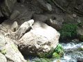
 Horton Creek Trail, Payson, Arizona courtesy of davidpinter↗

 Horton Creek Trail Payson Arizona Panoramio 55 courtesy of davidpinter↗
 Horton Creek Trail Payson Arizona Panoramio 52 courtesy of davidpinter↗
 Horton Creek Trail Payson Arizona Panoramio 48 courtesy of davidpinter↗
 Horton Creek Trail Payson Arizona Panoramio 58 courtesy of davidpinter↗
 Horton Creek Trail Payson Arizona Panoramio 11 courtesy of davidpinter↗


Added by camilledupar
Trails
Distance ?
3.5 milesElevation Gain ?
1,178 feetReal Ascent ?
1,342 feetReal Descent ?
164 feetAvg Grade (4°)
6%Grade (-9° to 23°)
-15% to 42%Distance ?
1.1 milesElevation Gain ?
-1,272 feetReal Ascent ?
65 feetReal Descent ?
1,337 feetAvg Grade (-13°)
-23%Grade (-34° to 14°)
-67% to 25%Elevation differences are scaled for emphasis. While the numbers are accurate, the cut-away shown here is not to scale.
Other Hiking Trails and Backpacking Trails Nearby

Upper Tonto Creek Campground
Payson, Arizona
0.3 miles SUpper Tonto Creek Campground is a beautiful place to camp at the intersection of Tonto and Horton Creeks. In addition to camping, this is a popular destination to both fish and hike. The campground...
Camp, Hike 0.8 mi
Promontory Butte
Payson, Arizona
2.0 miles EThis destination is on the edge of Promontory Butte, providing spectacularly scenic views as part of the Mogollon Rim. There are several old forest roads on the mountain that can serve as trails to...
Hike 0.8 mi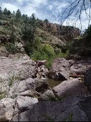
Christopher Creek Gorge
Payson, Arizona
2.9 miles SEChristopher Creek Gorge is a fun swimming or canyoneering destination located in Christopher Creek, just outside of Payson, Arizona. To get there, you have to hike from the Christopher...
Canyoneer, Hike, Swim 1.1 mi
Christopher Creek Campground
Payson, Arizona
3.7 miles SEChristopher Creek is a popular campground situated just east of Payson, nestled between the Christopher Creek river, and the town of the same name. This site is used for both overnight and day-use...
Camp, Canyoneer, Cross-country Ski, Hike, Swim 3.3 mi
See Canyon Trail
Payson, Arizona
4.6 miles ESee Canyon Trail #184 takes the hiker on a journey through the wooded Arizona wilderness surrounding Christopher Creek, and leading up the Mogollon Rim. This trail has trailhead markers at the...
Hike
Hell's Gate
Payson, Arizona
8.2 miles SThis Wilderness was established in 1984, and contains approximately 37,440 rough acres with a major canyon and perennial stream extending its entire length. Deep pools of water may be separated by...
Backpack, Camp, Hike, Swim 4.0 mi
Woods Canyon Lake
Payson, Arizona
8.6 miles EWoods Canyon Lake is a fishing lake near Payson, Arizona located near the Mogollon Rim. The lake has a hike that loops around it, and several other hikes nearby to look at the particularly scenic...
Camp, Hike, Swim 3.3 mi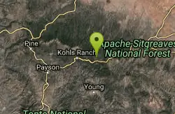
Meadow Trail #505
Payson, Arizona
8.7 miles EMeadow Trail #505 is a paved path that leads from the edge of Woods Canyon Lake to the scenic edge of the Woods Canyon vista. This hike is smooth enough to allow for easy access by wheelchairs,...
Hike 4.6 mi
Gordon Creek Falls
Payson, Arizona
9.0 miles SEGordon Creek Falls is a relatively unknown little oasis in the middle of the Arizona desert--specifically, outside of the city of Payson. The falls come from Gordon Creek, which winds its way through...
Hike, Swim 0.5-0.6 mi
Ellison Creek Falls
Payson, Arizona
10.7 miles WEllison Creek provides 4 beautiful waterfalls in this area, each with their own swimming and diving opportunities. There are even fishing spots where trout can be caught. Since the falls are close to...
Dive, Hike, Swim
Haigler Canyon Campground
Payson, Arizona
11.3 miles SEThis campground was constructed in 2007 and offers 2 day-use sites and 2 campground areas with 14 overnight sites. This campground boasts a diversity of trees. Fishing for rainbow trout is a popular...
Camp, Hike, Swim
Sinkhole Campground
Payson, Arizona
12.2 miles ESinkhole Campground is a camping area near Willow Springs Lake. There are also hikes, mountain biking trails, and fishing opportunities nearby. There are 26 campsites in total at this...
Camp, Hike, Mountain BikeEast Clear Creek
Happy Jack, Arizona
15.1 miles NEast Clear Creek is a river that stretches through the Mogollon Rim area of Arizona. It provides water to the surrounding desert landscape, fishing opportunities, and various areas to hike,...
Canyoneer, Hike, Swim 1.6-3.6 mi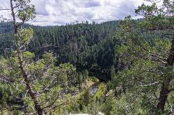
Kinder Crossing Trail #19
Happy Jack, Arizona
16.2 miles NKinder Crossing Trail #19 travels down to the beauty of East Clear Creek, and then extends up until reaching FR 137; but many people use the trail to reach the creek waters and play in the water. The...
Hike, Swim
Bearfoot Trail
Strawberry, Arizona
22.6 miles WHike and Mountain Bike near Strawberry, Arizona
Hike, Mountain Bike 1.9 mi
Maxwell Trail No. 37
Happy Jack, Arizona
22.9 miles NWThe Maxwell Trail leads over the Mongollan Rim down the canyon into West Clear Creek. Although still somewhat steep, it is an easier hike than shorter neighboring Tramway trail, which shares its...
Hike, Swim 0.6-2.9 mi
Tramway Trail No. 32
Happy Jack, Arizona
23.9 miles NWTramway Trail is a very short but very steep hike down the ridge of the Colorado Plateau to the nearby West Clear Creek. The trail crosses over the sharp edge of the Mogollan Rim, and descends to the...
Hike, Rock Climb, Swim 2.2-6.1 mi
Fossil Creek Dam (Toilet Bowl)
Pine, Arizona
27.4 miles WHidden within the vast Arizona desert is an oasis of a river that brings the surrounding banks to life around it. This is Fossil Creek--one of Arizona's two designated "Wild and...
Dive, Hike, Swim 0.1-3.8 mi
Fossil Springs Trail No. 18
Pine, Arizona
27.4 miles WLocated within the Fossil Springs Wilderness, this trail leads down a canyon to the springs for which it is named. At the trailhead, there are several hikes, some of which are available for...
Hike, Horseback, Swim 1.1 mi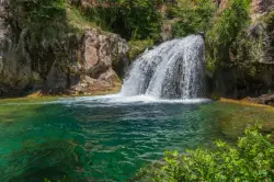
Fossil Creek Waterfall
Pine, Arizona
29.9 miles WFossil Creek is one of Arizona's two designated "Wild and Scenic" rivers. The waterfall is the most popular place to visit to cool off and see the natural beauty. Located between...
Hike, SwimNearby Campsites
Upper Tonto Creek Campground
Payson, Arizona
0.3 miles SUpper Tonto Creek Campground is a beautiful place to camp at the intersection of Tonto and Horton Creeks. In addition to camping, this is a popular destination to both fish and hike. The campground...
Camp, Hike 1.1 mi
Christopher Creek Campground
Payson, Arizona
3.7 miles SEChristopher Creek is a popular campground situated just east of Payson, nestled between the Christopher Creek river, and the town of the same name. This site is used for both overnight and day-use...
Camp, Canyoneer, Cross-country Ski, Hike, Swim
Hell's Gate
Payson, Arizona
8.2 miles SThis Wilderness was established in 1984, and contains approximately 37,440 rough acres with a major canyon and perennial stream extending its entire length. Deep pools of water may be separated by...
Backpack, Camp, Hike, Swim 4.0 mi
Woods Canyon Lake
Payson, Arizona
8.6 miles EWoods Canyon Lake is a fishing lake near Payson, Arizona located near the Mogollon Rim. The lake has a hike that loops around it, and several other hikes nearby to look at the particularly scenic...
Camp, Hike, Swim
Aspen Campground
Payson, Arizona
8.6 miles EAspen Campground is a large campground near Payson, Arizona. Between the proximity to Woods Canyon Lake and the seclusion of the encompassing Apache-Sitgreaves National Forest, this is a...
Camp
Haigler Canyon Campground
Payson, Arizona
11.3 miles SEThis campground was constructed in 2007 and offers 2 day-use sites and 2 campground areas with 14 overnight sites. This campground boasts a diversity of trees. Fishing for rainbow trout is a popular...
Camp, Hike, Swim
Sinkhole Campground
Payson, Arizona
12.2 miles ESinkhole Campground is a camping area near Willow Springs Lake. There are also hikes, mountain biking trails, and fishing opportunities nearby. There are 26 campsites in total at this...
Camp, Hike, Mountain Bike
Verde Hot Springs
Camp Verde, Arizona
34.3 miles WVerde Hot Springs are a few natural hot spring pools located along the Verde River, near Sedona, Arizona. Once a resort, now all that remains are the foundations and the hot pools...
Camp, Hike, Hot Springs 0.4 mi
Clear Creek Campground
Camp Verde, Arizona
40.1 miles WWest Clear Creek flows along the boundary of this desert canyon country camp and is a popular place for hiking, swimming, wading and fishing. Cool water species such as smallmouth bass and green...
Camp, Hike, Swim
Beaver Creek Campground
Camp Verde, Arizona
41.9 miles NWCamp, Canoe, Kayak, and Swim near Camp Verde, Arizona
Camp, Canoe, Kayak, Swim
Beaver Creek Dispersed Camping
42.8 miles NW
Free dispersed camping on the cliffs above Beaver Creek.
Camp


