


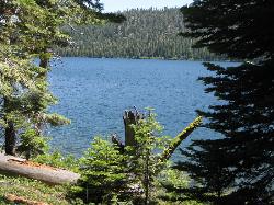
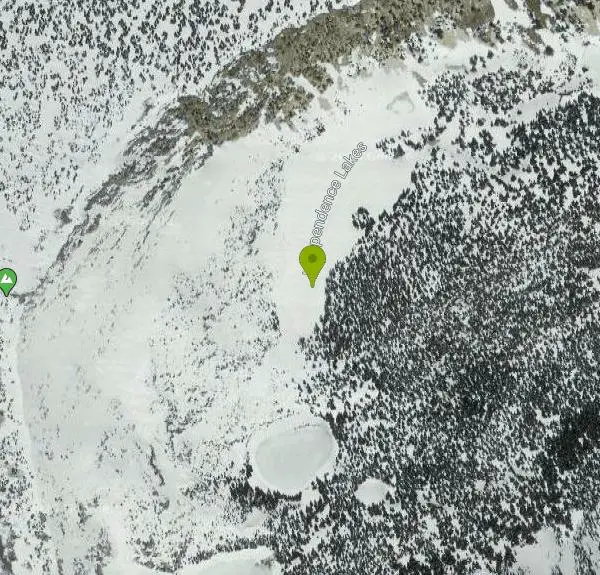
Independence Lakes
Elba, Idaho
| Address: | Independence Lakes, Idaho 83342, USA |
| GPS: |
42°12'43.7"N 113°41'33.6"W Maps | Directions |
| State: | Idaho |
| Trail Length: | 7.70 miles |
| Trail Type: | Loop |
| Hike Difficulty: | Advanced |
| Trails/Routes: | 4.8 mi |
Restrooms Picnic Tables Lakes Streams Trails Rocks Wildflowers Fall Colors Pet Friendly Bicycles Fishing National Park Paintball Permitted
Backpack, Camp, Canoe, Hike, Kayak, and Swim
The Independence Lakes hike is a 7.7 mile hike that gets progressively better the farther you go. At the summit of Mt. Independence, you will get a birds eye view of four beautiful jewel tone glacial lakes that make up the Independence Lakes.The Independence Lakes have an emerald green color tone and crispy, clear water. These lakes are home to six different species of fish, who have called these lakes home since the glaciers disappeared over 10,000 years ago.
There is a little something for everybody on this hike. For those who like to animal watch, you're in luck! The trail is home to many animals that can be seen any time of the year. There is fishing available along the shoreline, and for those who enjoy endless water fun, watercraft is available to the public on a first come first serve basis.They are completely free, although donations are appreciated! The watercrafts include: kayaks, motorized boats, and floats. These watercrafts are available from Memorial Day weekend through October 1st.
This hike is also beautiful during the Fall. Although the trail is long and narrow, there is a steady path in the form of an intense arch all the way to the summit of the mountain. The colors of the fall leaves dance off the reflection of the lakes making for a beautiful 360 view along the hike. If you enjoy your time on the trail and wish it wouldn't end, Independence Lakes Campground is a non-fee campground equipped with picnic tables and does not require a reservation. The campground has 5 single sites, which means it is on a first come first serve basis. It is noted that a majority of the campers camp at the trailhead,and day hike to the lake for convenience.
This location is wonderful. Independence Lakes is the perfect non-fee place to go to with friends, family, or on your own. It does not need to be completed in its entirety for one to enjoy the beauty, but it is possible!
More Information
Be courteous, informed, and prepared. Read trailhead guidelines, stay on the trail, and don't feed the wildlife.
Read More- Plan Ahead and Prepare
- Travel & camp on durable surfaces
- Dispose of waste properly
- Leave what you find
- Minimize campfire impacts
- Respect wildlife
- Be considerate of other visitors
Directions
From Elba, Idaho
- Head west on E 1950 S toward S 1125 E (0.7 mi)
- Turn right onto S 1125 E/
E Oakley Elba Rd (0.3 mi) - Turn left onto E 1925 Rd S/
E Oakley Elba Rd Continue to follow E Oakley Elba Rd(8.6 mi) - Turn left onto Forest Rd 738 (0.8 mi)
- Turn right onto Independence Lake Rd (2.6 mi)
From the Independent Lake campground to the lake, it is a 1 1/2 drive:
- Head west on Forest Rd 562 toward Forest Rd 606
- Turn right onto Forest Rd 606
- Turn right
- Turn left onto E 2300 S
- Turn right onto S 50 E
- Turn right onto E 1975 S/Basin Rd
- Continue onto E Oakley Elba Rd
- Slight right onto Independence Lake Rd
- Slight right to stay on Independence Lake Rd
- Turn right to stay on Independence Lake Rd
- Turn right to stay on Independence Lake Rd
*Destination will be on the right*


Trails
Distance ?
4.8 milesElevation Gain ?
1,817 feetReal Ascent ?
3,222 feetReal Descent ?
1,405 feetAvg Grade (4°)
7%Grade (-16° to 27°)
-29% to 52%Elevation differences are scaled for emphasis. While the numbers are accurate, the cut-away shown here is not to scale.
Other Swimming Holes, Hiking Trails, Canoeing Areas, Kayaking Areas, and Backpacking Trails Nearby
Castle Rocks State Park
Almo, Idaho
5.3 miles SNeighboring the popular climbing area City of Rocks, Castle Rock is a beautiful state park with plenty to do. This park opened to the public in 2003 and offers many additional climbing and hiking...
Camp, Hike, Rock Climb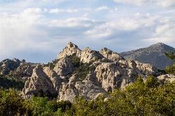
City of Rocks National Reserve
Malta, Idaho
9.3 miles SThe City of Rocks, or "The City" as locals call it, is one of the best places in the country to go rock climbing. Throughout the valley granite spires dominate the skyline, reaching...
Camp, Hike, Horseback, Mountain Bike, Rock Climb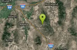
Sublett Creek Campground
Malta, Idaho
34.3 miles E5500-foot elevation. 9 campsites on Sublett Creek, and 2 miles east of Sublett Reservoir. Access to Sublett Reservoir from the north shore.Campground can be used for picnicking and holds 40 people....
Camp, Canoe
Indian Springs
Kimberly, Idaho
36.9 miles WMulti-use trail system in south of Kimberly / Twin Falls, Idaho. Used for Mountain Biking, Hiking, and Horseback Riding.
Hike, Hot Springs, Mountain Bike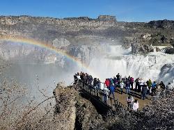
Shoshone Falls Park
Twin Falls, Idaho
44.6 miles NWThe view of Shoshone Falls is beautiful year round but it is simply breathtaking during spring runoff when the water levels are high and they roar so hard you can feel the mist hundreds of feet...
Hike
Perrine Bridge
Jerome, Idaho
47.1 miles NWPerrine Bridge is located just above the Snake River. It spans 1,500ft, and is 486ft above the Snake River. You can drive over this bridge on the way back from Boise, or get out, park, and take...
HikeNearby Campsites
Castle Rocks State Park
Almo, Idaho
5.3 miles SNeighboring the popular climbing area City of Rocks, Castle Rock is a beautiful state park with plenty to do. This park opened to the public in 2003 and offers many additional climbing and hiking...
Camp, Hike, Rock Climb
City of Rocks National Reserve
Malta, Idaho
9.3 miles SThe City of Rocks, or "The City" as locals call it, is one of the best places in the country to go rock climbing. Throughout the valley granite spires dominate the skyline, reaching...
Camp, Hike, Horseback, Mountain Bike, Rock Climb
Sublett Creek Campground
Malta, Idaho
34.3 miles E5500-foot elevation. 9 campsites on Sublett Creek, and 2 miles east of Sublett Reservoir. Access to Sublett Reservoir from the north shore.Campground can be used for picnicking and holds 40 people....
Camp, Canoe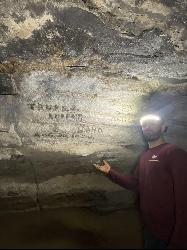
Kimama Wind Caves
Paul, Idaho
39.6 miles NThe Kimama Wind Caves are a series of lava tubes accessed by a crack in the middle of the desert north of Paul, Idaho. These lava tubes create a labyrinth of tunnels to explore. These tunnels should...
Camp, Cave


