


Meadow Lake
Leadore, Idaho
| GPS: |
44°25'59.1"N 113°19'4.8"W Maps | Directions |
| State: | Idaho |
| Trails/Routes: | 1.1-4.1 mi |
Camp, Canoe, and Hike
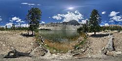
Meadow Lake is a serene high-alpine lake tucked beneath the rugged peaks of the Lemhi Range in east-central Idaho, on the Salmon-Challis National Forest near Leadore. Sitting at over 9,000 feet at the base of 10,720-foot Meadow Lake Peak, this little 13-acre gem offers crystalline mountain water, cool pine-scented air, and the kind of peaceful, far-from-it-all setting that makes the long drive in well worth it.
It's a wonderful spot to slow down and savor the high country. The clear lake is perfect for paddling a canoe or kayak across its glassy surface, and it's a favorite with anglers — the lake is stocked twice a year, so the trout fishing is reliably good whether you cast from the bank or carry a small boat down to the water (trolling motors only; there's no boat ramp). Hiking trails lead right out of the campground, including a gentle loop around the lake's backside and routes deeper into the Lemhi high country.
A cozy Forest Service campground sits right on the lakeshore, with around 17 sites (including a few doubles for larger groups), picnic tables, fire rings, vault toilets, and drinking water — a comfortable basecamp at altitude.
To reach it, drive about 17 miles south from Leadore on Highway 28 to the old Gilmore townsite, then turn west onto Forest Road 002 and climb roughly 6 gravel miles to the lake. The season is short at this elevation: roughly July through Labor Day for reliable access, with the campground first-come outside that window as weather permits. Bring warm layers for crisp mountain nights, plenty of water, and your fishing rod, pack out everything, and enjoy one of the Lemhi Range's most peaceful alpine retreats.
More Information
Meadow Lake Campground - Recreation.gov
We’re here to help you dream up your next trip, figure out the details, and reserve experiences at over 3,600 facilities and 103,000 individual sites across the country.
https://www.recreation.gov/camping/campgrounds/260558Meadow Lake Campground in Salmon-Challis National Forest, Idaho: Reviews and Photos 2026 | Hipcamp
Thinking of camping at Meadow Lake Campground in Salmon-Challis National Forest, ID? See campsite availability, read camper reviews, and discover more incredible campsites nearby.
https://www.hipcamp.com/en-US/campground/united-states/idaho/meadow-lake-campground-lv74cgyySalmon-Challis National Forest | Recreation | Forest Service
Find and Discover Recreation Sites and Trails in Salmon-Challis National Forest
https://www.fs.usda.gov/r04/salmon-challis/recreationBe courteous, informed, and prepared. Read trailhead guidelines, stay on the trail, and don't feed the wildlife.
Read More
- Plan Ahead and Prepare
- Travel & camp on durable surfaces
- Dispose of waste properly
- Leave what you find
- Minimize campfire impacts
- Respect wildlife
- Be considerate of other visitors
Directions
From Leadore, Idaho
- Head northeast on Carbonate St toward S Railroad St (138 ft)
- Turn right onto ID-28 S/S Railroad StContinue to follow ID-28 S(15.4 mi)
- Turn right onto NF-212 (0.3 mi)
- Turn left (1.2 mi)
- Turn right (0.9 mi)
- Keep right (0.2 mi)
- Turn right (0.2 mi)
- Turn right onto Forest Rd 002 (3.7 mi)
- Slight right to stay on Forest Rd 002Destination will be on the right(0.2 mi)
From Leadore, Idaho go south 16.8 miles on Hwy. 28. Turn right (west) and follow FS road #60002 for 6.5 miles thru the ghost town of Gilmore and climbing up to the campground (elevation 9,200 feet).


Other Hiking Trails and Canoeing Areas Nearby

Birch Creek Charcoal Kilns
Leadore, Idaho
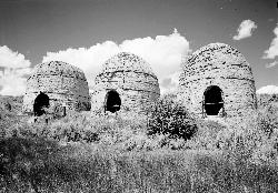
10.9 miles SESixteen remarkably intact 20-foot beehive brick kilns stand in remote Idaho as relics of an 1880s silver-mining operation that employed 200 workers for barely three years.
Hike 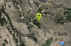
Webber Creek
Dubois, Idaho
31.5 miles EA dispersed recreation area at 7,000 feet elevation with a trailhead, vault toilet, and the Webber Creek Trail heading west toward Scott Peak — great for hiking, fishing, horseback riding, and mountain biking.
Backpack, Camp, Hike, Horseback, Hot Springs, Mountain Bike 7.9 mi
Borah Peak
Mackay, Idaho
33.0 miles SWIdaho's highest peak at 12,662 feet offers a Class 3-4 summit route along 'Chicken-out' Ridge — complete with a snow knife-edge, talus, and the kind of exposure that separates the committed from the casual.
Hike 0.6 mi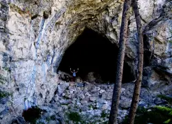
Hidden Mouth Cave
Moore, Idaho
33.0 miles SA surprisingly large lava cave with three chambers and a secret back exit — reached by quad or a quarter-mile steep hike above Moore, Idaho.
Cave, Hike 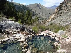
Goldbug (Elk Bend) Hot Springs
Salmon, Idaho
44.8 miles NWA 4-mile out-and-back hike near Salmon, Idaho, leading to rock-laid hot springs on a hillside — the first stretch crosses private property, so please be respectful of that access.
Hike, Hot SpringsNearby Campsites
Birch Creek
Leadore, Idaho
29.0 miles SEA campground along Birch Creek with 25 developed sites, picnic tables, fire rings, and restrooms — plus great fishing for brook, rainbow, and brown trout in the creek and nearby Caribou-Targhee access.
Camp
Webber Creek
Dubois, Idaho
31.5 miles EA dispersed recreation area at 7,000 feet elevation with a trailhead, vault toilet, and the Webber Creek Trail heading west toward Scott Peak — great for hiking, fishing, horseback riding, and mountain biking.
Backpack, Camp, Hike, Horseback, Hot Springs, Mountain Bike


