


123 Mountain Bike Trails near East Maricopa Floodway
first prev 1 2 3 4 5 6 7 next lastShowing Mountain Bike Trails within 50 miles Distance miles of Roosevelt WCD Canal Road, Mesa, AZ 85205, USA City, Zip, or Address
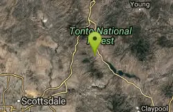
Sycamore Trail #68
Tonto Basin, Arizona
34.8 miles NEFrom FR 421, the trail climbs steadily through lower Sonoran Desert and riparian vegetation up the arroyo formed by Sycamore Creek. It turns northward and continues to climb along a...
Mountain Bike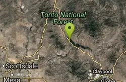
Three Bar Route
Tonto Basin, Arizona
36.4 miles NEThe Three Bar Wildlife Enclosure is a fenced wildlife study area operated by Arizona Game and Fish. The proximity of two recreation sites provides ample parking should you want to cool...
Mountain Bike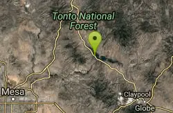
Vineyard Trail #131
Tonto Basin, Arizona
36.5 miles NETrail passes through a variety of Lower Sonoran Desert vegetation plant communities. Spectacular views of Roosevelt Lake, Apache Lake, Roosevelt Dam and Four Peaks. Historic Camp...
Mountain Bike
Sunrise Mountain Trail
Peoria, Arizona
37.3 miles NWThe Sunrise Mountain Trail can be found within the suburban area of Peoria, Arizona; it is made of up 3 sequential loops; each loop harder than the last. The trail is easy to find, as...
Hike, Mountain Bike 2.9 mi
Coldwater Trail
Goodyear, Arizona
37.6 miles WThe Cold Water Trail #27 is a seldom visited, remote backcountry destination along the backdrop of the rugged Verde Rim with healthy mixed vegetation and unique geology. The trail was originally used...
Hike, Horseback, Mountain Bike 13.8 mi
Butterfield to Gadsen Loop Trail
Goodyear, Arizona
37.6 miles WAs with other trails in Estrella, the trail is wide and the surface tends to be rather benign, varying from mostly smooth, to occasionally strewn with small rocks, sandy in the washes. Butterfield...
Hike, Horseback, Mountain Bike 3.6 mi
Toothaker Trail
Goodyear, Arizona
37.8 miles WToothaker is an easy roller coaster of a trail. It crosses numerous washes ranging from small to large and can be a tad loose and/or rocky in some sections. The end reward is a nice view of Rainbow...
Hike, Horseback, Mountain Bike
Estrella Mountain Park
Goodyear, Arizona
37.8 miles WNice mix of singletrack and doubletrack. One way loops, long loop and tech loop. A few mild climbs and some mild rock gardens, just let it ride. There is a lot of loose rocks on the...
Mountain Bike
Dysart Trail
Goodyear, Arizona
37.8 miles W$6 entry fee per car.
Hike, Horseback, Mountain Bike
Rainbow Valley to Toothaker Loop Trail
Goodyear, Arizona
37.8 miles WEstrella Mountain Regional Park has many trails within it, a great beginner to intermediate friendly trail is the Rainbow Valley to Toothaker Loop Trail. This 6.6 mile hike is mostly flat with a few...
Hike, Horseback, Mountain Bike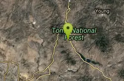
Park Trail #66
Tonto Basin, Arizona
38.1 miles NEFrom the Park Creek Trailhead, the trail crosses Park Creek and climbs gradually through lower Sonoran Desert and riparian vegetation for ½ mile. The trail then ascends steeply...
Mountain Bike 1.0 mi
Quail Trail
Goodyear, Arizona
38.2 miles WQuail Trail is the access trail from the Nature Center to the main trail system. It is a pretty steep climb, but smooth and steady. Quail Trail is a spur trail in the Estrella Mountain...
Hike, Horseback, Mountain Bike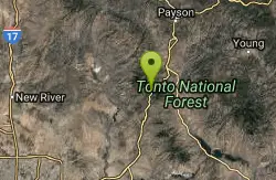
Slate Creek Divide Loop
Phoenix, Arizona
39.8 miles NEVarious routes available - Alternative #1 (From above): 13 Mi. (22 km) Alternative #2 (From above): 10 Mi. (16 km) Loop top half only (Inc. dirt. to 8 from SR 87): 12 Mi. (19 km) Figure eight: 16 Mi....
Mountain Bike
Casa Grande Mountain
Casa Grande, Arizona
40.3 miles SThere are easy trails by the starting point but they are not the main trail. It climbs the mountain side and heads south along the range. Jumping Cholla is a common plant here and the...
Mountain Bike
Black jack
Goodyear, Arizona
40.9 miles WExtreme terrain, advance riders only.
Mountain Bike
Emery Henderson
Phoenix, Arizona
41.5 miles NWBct(Black Canyon Trail) trail head features paved parking and restrooms. From here you can head south on relatively flat ground, or North, working into the desert hills, on multiuse...
Mountain Bike
South, Bajada, Mule Deer Loop Trail
Waddell, Arizona
46.2 miles WSouth - Bajada - Mule Deer Loop is a 4.1 mile loop trail located near Waddell, Arizona that offers the chance to see wildlife. The trail is rated as moderate and is accessible from...
Hike, Horseback, Mountain Bike
White Tanks Regional Park Trails
Waddell, Arizona
46.3 miles WI have not ridden these trails yet, but I was surprised that they were not listed yet on the ST's database. There are 28 miles of multi-use trails in the park, not including the park's...
Mountain Bike

Mule Deer Trail (Maricopa Trail)
Waddell, Arizona
46.4 miles WMule Deer trail is a 3.5 mile out-and-back trail that it part of the Maricopa Trail within White Tank Mountain Regional Park. This is a beginner to moderate friendly trail for both hikers and...
Hike, Horseback, Mountain Bike
Goat Camp Trail
Buckeye, Arizona
46.4 miles WGoat Camp Trail is a well-liked mountain biking and hiking trail in White Tank Mountain Regional Park. This is a 16 mile out-and-back trail that is rated as advanced due to the length, as well as the...
Hike, Mountain Bike


