Peek-a-boo Gulch
Escalante, Utah
| Address: | Kane County, UT, USA |
| GPS: |
37°28'36.2"N 111°13'12.8"W Maps | Directions |
| State: | Utah |
| Trails/Routes: | 3.7 mi |
Rocks Wildflowers Restrooms Picnic Tables
Hike
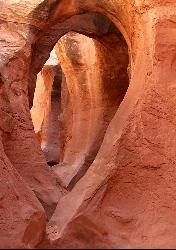
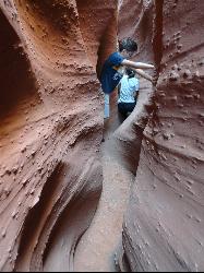
Peek-a-boo Gulch is located in the scenic Grand Staircase National Monument near Escalante, Utah and adjacent to Spooky Gulch. It is not to be confused with Red Slot Canyon AKA Peekaboo. These two slot canyon hikes are usually hiked together as a loop that totals in about 3.5 miles. The trail is not really long but it is a fun area to explore. It is a great hike for any skill level and for families to explore a place that has so much natural beauty. There are a few areas where there is stagnant water that can usually be avoided if hikers do not want to get wet. Just in case, make sure to bring extra clothes or shoes in case any slips happen or you don't mind getting wet after all.
Peek-a-boo Gulch was named for the rock formations in the slot canyons that hikers can see through to the other side. It is one of the many natural wonders that exist in the State of Utah that is a must see for any avid slot canyon hiker. Be advised, as with any slot canyon, to be aware of local weather patterns before hiking to avoid any flash floods, which can be very dangerous and fatal if you find yourself caught in one. The best time of year to hike Peek-a-boo Gulch is from May to September.
Any avid hiker will not want to miss this incredible hike in beautiful Southern Utah. This slot canyon is much less crowded than many of the slot canyons in the State and is one you can enjoy with the whole family!
More Information
Hiking in Utah | Utah.com
The best way to experience the diverse landscapes of Utah is by hiking through them. Find information on hiking trails in Utah here.
https://www.utah.com/things-to-do/outdoor-recreation/hiking-backpacking/Peek-a-Boo and Spooky Slot Canyons via Upper Dry Fork Trailhead
Peek-a-Boo and Spooky Slot Canyons are a bucket list adventure. They are two of the most spectacular slot canyons in Utah.
https://www.utahsadventurefamily.com/peek-a-boo-and-spooky-slot-canyons/Top Things to Do in Bryce Canyon Country | Plan Your Trip
Plan your visit to Bryce Canyon and surrounding areas. Discover hiking trails, lodging, restaurants, and nearby attractions. Find travel information here!
https://www.brycecanyoncountry.com/Be courteous, informed, and prepared. Read trailhead guidelines, stay on the trail, and don't feed the wildlife.
Read More- Plan Ahead and Prepare
- Travel & camp on durable surfaces
- Dispose of waste properly
- Leave what you find
- Minimize campfire impacts
- Respect wildlife
- Be considerate of other visitors
Directions
From Escalante, Utah
- Head east on UT-12 E/
W Main St toward S Center St Continue to follow UT-12 E(5.0 mi) - Turn right onto BLM200/
Hole in the Rock Rd (26.0 mi) - Slight left onto Bureau of Land Management 252 (1.7 mi)
There is a large sign board map at the trailhead. From there the trail goes West for almost 3 miles before merging onto a larger trail. Go left (North) on this trail. From there, it's just under a mile to the cave.


Other Hiking Trails Nearby
Spooky Gulch
Escalante, Utah
0.0 miles SEA short slot canyon hike near Escalante with sections so narrow they're genuinely 'spooky' — sandy trails, stagnant water pools, and flash flood awareness required.
Hike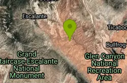
Neon Canyon and Golden Cathedral
Escalante, Utah
8.0 miles NDeep in lower Neon Canyon, three pothole arches carved into the overhang form the Golden Cathedral — when the midday sun shines through, golden light columns illuminate the domed pour-off below.
Backpack, Canyoneer, Hike 20.4 mi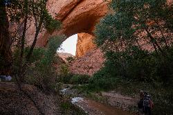
Coyote Gulch
Escalante, Utah
11.1 miles SEA remote 26-mile backpacker's slot canyon near Escalante with a flowing river, natural arches including Coyote Natural Arch and Jacob Hamblin Arch, and nights under the stars.
Backpack, Canyoneer, Hike 5.7 mi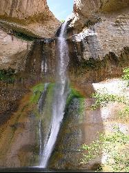
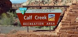
Lower Calf Creek Falls
Boulder, Utah
24.3 miles NWA stunning 126-foot waterfall at the end of an easy 6-mile canyon hike rewards with a cool swimming pool framed by cottonwood trees and ancient petroglyphs.
Hike, Swim 12.1 mi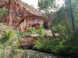
Escalante River
Escalante, Utah
28.3 miles NWHike and Horseback near Escalante, Utah
Hike, Horseback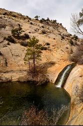
Upper Calf Creek Falls
Boulder, Utah
29.0 miles NWUpper Calf Creek Falls is a stunning desert oasis hidden in the slickrock country of Grand Staircase-Escalante National Monument, between Escalante and Boulder, Utah. An 87-foot waterfall pours over...
Hike, Swim