


Escalante River
Escalante, Utah
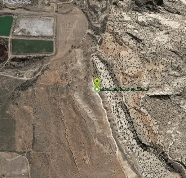
| Address: | Escalante River Trailhead, Escalante, UT 84726, USA |
| GPS: |
37°46'16.9"N 111°34'45.6"W Maps | Directions |
| State: | Utah |
| Trails/Routes: | 12.1 mi |
Rivers Streams Trails Rocks Wildflowers Restrooms Picnic Tables Lakes Waterfalls Glaciers Ponds
Hike and Horseback
More Information
Add ResourceBe courteous, informed, and prepared. Read trailhead guidelines, stay on the trail, and don't feed the wildlife.
Read More- Plan Ahead and Prepare
- Travel & camp on durable surfaces
- Dispose of waste properly
- Leave what you find
- Minimize campfire impacts
- Respect wildlife
- Be considerate of other visitors
Directions
From Escalante, Utah
- Head east on W Main St toward S Center St (0.4 mi)
- Turn left onto E Main St (358 ft)
- Turn left onto N 300 E (0.2 mi)
- Turn right onto 190 N St (0.4 mi)
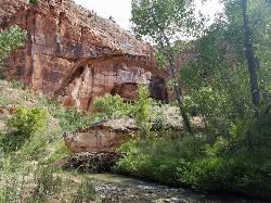
 Natural Bridge courtesy of katiemia↗

 Walking In The River courtesy of katiemia↗
 Along The Cliffs courtesy of katiemia↗
 Amphitheater courtesy of katiemia↗
 Amphitheater Petroglyphs courtesy of katiemia↗
 Beautiful Foliage courtesy of katiemia↗
 Down The Canyon courtesy of katiemia↗
 In The River courtesy of katiemia↗

Added by katiemia
Other Hiking Trails and Horseback Trails Nearby
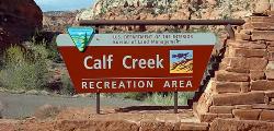
Lower Calf Creek Falls
Boulder, Utah
9.1 miles EA stunning 126-foot waterfall at the end of an easy 6-mile canyon hike rewards with a cool swimming pool framed by cottonwood trees and ancient petroglyphs.
Hike, Swim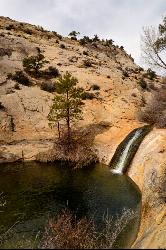
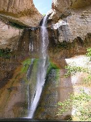
Upper Calf Creek Falls
Boulder, Utah
9.8 miles NEUpper Calf Creek Falls is a stunning desert oasis hidden in the slickrock country of Grand Staircase-Escalante National Monument, between Escalante and Boulder, Utah. An 87-foot waterfall pours over...
Hike, Swim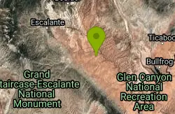
Neon Canyon and Golden Cathedral
Escalante, Utah
23.3 miles SEDeep in lower Neon Canyon, three pothole arches carved into the overhang form the Golden Cathedral — when the midday sun shines through, golden light columns illuminate the domed pour-off below.
Backpack, Canyoneer, Hike 3.7 mi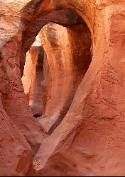
Peek-a-boo Gulch
Escalante, Utah
28.3 miles SEA fun slot canyon hike in Grand Staircase-Escalante with named rock formations you can see straight through — often hiked as a 3.5-mile loop with neighboring Spooky Gulch.
Hike 4.9 mi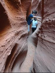
Spooky Gulch
Escalante, Utah
28.3 miles SEA short slot canyon hike near Escalante with sections so narrow they're genuinely 'spooky' — sandy trails, stagnant water pools, and flash flood awareness required.
Hike 0.1-0.3 mi
Mossy Cave
Tropic, Utah
30.2 miles WAn easy mile-long trail past red rock hoodoos, a mossy cave with a summer waterfall and winter icicle curtain, and a charming stream to wade through in water shoes.
Hike 7.6 mi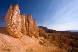
Fairyland Loop Trail
Bryce, Utah
32.2 miles WAn 8-mile loop descending 900 feet into Bryce Canyon's red and white hoodoos, connecting back along Rim Trail at Sunrise Point — with a 200-yard detour to the Tower Bridge rock formation.
Hike 0.5-5.4 mi
Rim Trail
Bryce, Utah
33.4 miles WA 5.5-mile Bryce Canyon rim hike connecting every major viewpoint above the Hoodoos, from Fairyland Point to Bryce Point — partially paved and wheelchair accessible at the midpoint.
Hike 2.3 mi
Queens Garden Trail
Bryce, Utah
33.5 miles WA descent through hoodoos and tunnels in Bryce Canyon's main amphitheater starting at Sunrise Point — well-kept dirt trail with benches, detour to a Queen Victoria rock formation, and a forest ecosystem below.
Hike 1.6 mi
Hat Shop
Bryce, Utah
33.6 miles WA moderately difficult 4-mile out-and-back hike to Bryce Canyon's Hat Shop — balancing gray boulders on slender red stilts, plus Pink Cliffs and far-off mountain views.
Hike 3.1 mi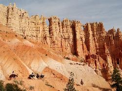
Peek-a-boo Loop
Bryce, Utah
33.7 miles WA strenuous 5-mile hike through quiet canyon trails with up-close hoodoo views, a shaded respite at the loop's bottom, and sweeping views of the Bryce Amphitheater.
Hike 1.8 mi
Tower Bridge
Bryce, Utah
33.7 miles WA moderately difficult 3-mile round trip from Sunrise Point past classic Bryce Canyon hoodoos to a dramatic rock formation resembling London Bridge — less crowded the further you go.
Hike 1.2 mi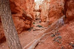
Navajo Trail
Bryce, Utah
33.7 miles WA short but winding 1.5-mile loop descending into Bryce Canyon's amphitheater, where towering hoodoos, Thor's Hammer, Twin Bridges, Wall Street, and 750-year-old Douglas Firs surround you.
Hike 4.1 mi
Swamp Canyon Overlook and Trail
Bryce, Utah
37.0 miles WA lesser-explored loop trail through Bryce Canyon's pink and red cliffs and forested Ponderosa Pines, descending and ascending 800 feet in a peaceful counter-clockwise circuit.
Hike 20.4 mi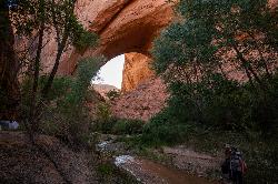
Coyote Gulch
Escalante, Utah
39.2 miles SEA remote 26-mile backpacker's slot canyon near Escalante with a flowing river, natural arches including Coyote Natural Arch and Jacob Hamblin Arch, and nights under the stars.
Backpack, Canyoneer, Hike 1.0 mi
Bristlecone Loop
Kanab, Utah
41.6 miles SWA 1-mile loop from Rainbow Point — the highest spot in Bryce Canyon — past 1,800-year-old Bristlecone pines, cliff-top views, and wildlife including woodpeckers, owls, and chipmunks.
Hike 8.2 mi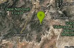
Riggs Spring Loop Trail
Kanab, Utah
41.7 miles SWOne of Bryce Canyon's least-traveled trails — an 8-mile loop descending 2,248 feet through ponderosa pines and Pink Cliffs views near Rainbow Point, strenuous but serenely off the beaten path.
HikeNearby Campsites
Calf Creek Campground
Boulder, Utah
9.1 miles ECamp, Dive, and Swim near Boulder, Utah
Camp, Dive, Swim
North Campground
Bryce, Utah
33.5 miles WOne of Bryce Canyon's main campgrounds, with 99 RV and tent sites, restrooms with flush toilets, picnic tables, fire grates, and a nearby summer General Store with showers and laundry.
Camp
Sunset Campground
Bryce, Utah
34.1 miles WA spacious first-come, first-served campground inside Bryce Canyon with 101 sites across three loops, fire grates, drinking water, and flushing restrooms — no hookups.
Camp


