


Quarry Trail
Cool, California

| Address: | Quarry Trail, Cool, CA, USA |
| GPS: |
38°54'57.1"N 121°1'25.7"W Maps | Directions |
| State: | California |
| Trails/Routes: | 5.6 mi |
Rivers Trails Pet Friendly Bicycles
Hike
This is a hike along the river and an old, historic railway. The trail leads you to a a beautiful amphitheater carved from limestone.You are surrounded by beautiful nature and peaceful noises. The trail is wide and you can take your time to take in all the beauty. The only part that is a little more difficult is the last stretch up to the quarry.
The railway that you will see used to carry out limestone and was taken 7 miles to Auburn for cement productions. Each train was filled about four times a day. In 1942, the metal from the old railway was used as scrap metal during WWII.
There are some places on the trail that aren't clearly marked, especially when you get to the quarry. Stay wary of where you are and keep an eye out for signs that will guide you to where you need to go. The trail is great all year around, but between April and June, the wildflowers are the most beautiful.
KEEP IN MIND: California does charge $10 as a day-use fee for each car going into the parking area, although prices are subject to change. Dogs are allowed if they are leashed. There are no bikes allowed on this hike.
More Information
Be courteous, informed, and prepared. Read trailhead guidelines, stay on the trail, and don't feed the wildlife.
Read More- Plan Ahead and Prepare
- Travel & camp on durable surfaces
- Dispose of waste properly
- Leave what you find
- Minimize campfire impacts
- Respect wildlife
- Be considerate of other visitors
Directions
From Cool, California
- Head north on CA-193 W/CA-49 N toward Northside Dr (3.1 mi)
- Turn right onto Quarry Trail (0.8 mi)
From Sacramento take Interstate 80 to the Elm Avenue exit in Auburn. Make two lefts onto Highway 49. Drive 2.5 miles down to the American River Confluence. Turn right at the confluence to stay on Highway 49. Make a quick left into the Quarry Trailhead parking lot. Cost is $10 per vehicle. Or you can use a yearly state parks Poppy Pass to park.Courtesy of sacbee.com


Trails
Distance ?
5.6 milesElevation Gain ?
26 feetReal Ascent ?
1,635 feetReal Descent ?
1,609 feetAvg Grade (0°)
0%Grade (-26° to 32°)
-48% to 63%Elevation differences are scaled for emphasis. While the numbers are accurate, the cut-away shown here is not to scale.
Other Hiking Trails Nearby

Lake Clementine Trail Loop
Auburn, California
0.6 miles WLocated in Auburn, California, Lake Clementine Trail Loop is a hike along the North Fork American River is an easy to moderate trail with an elevation gain of 785 ft. It's wheelchair...
Camp, Canoe, Hike, Kayak, Mountain Bike, Swim 0.1 mi
Edwards Crossing
Nevada City, California
28.7 miles NEdwards Crossing is a popular and easily accessible swimming hole on the Yuba River. The swimming hole is named for Edwards Crossing Bridge which can be viewed from there. The river here is...
Hike, Swim
North Fork Falls
Colfax, California
30.1 miles NEA very popular hike in the summer time, North Fork Falls offers a pleasant break from the city while enjoying the beautiful Sierra Nevada mountains. Hike into the forest and visitors will find a...
Camp, Hike, Swim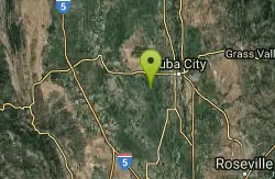
Sutter National Wildlife Refuge
Meridian, California
41.1 miles WSutter National Wildlife Refuge, the southern-most refuge in the Sacramento Refuge Complex, is located in the Sacramento Valley of California, about 50 miles north of the metropolitan area of...
Hike
Heath Falls Overlook Trail
Truckee, California
41.2 miles NEHike and Swim near Truckee, California
Hike, Swim
Palisades Creek Trail
Truckee, California
41.2 miles NEThe Palisades Creek Trail is a difficult hike that can be done in a day, but is better enjoyed as an overnight trip. This trail has showcases some beautiful waterfalls along the way as well as...
Hike, Swim
Shirley Canyon
Olympic Valley, California
45.9 miles NEHike near Olympic Valley, California
Hike 4.1 mi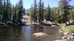
Shirley Lake Canyon Trail
Olympic Valley, California
46.2 miles NEShirley Lake is a pretty and pure lake located in Squaw Valley. The Shirley Lake Canyon Trail goes up into the rugged and lovely Sierra Mountains. You begin the trail in Squaw Valley Village and...
Hike, SwimNearby Campsites
Lake Clementine Trail Loop
Auburn, California
0.6 miles WLocated in Auburn, California, Lake Clementine Trail Loop is a hike along the North Fork American River is an easy to moderate trail with an elevation gain of 785 ft. It's wheelchair...
Camp, Canoe, Hike, Kayak, Mountain Bike, Swim
North Fork Falls
Colfax, California
30.1 miles NEA very popular hike in the summer time, North Fork Falls offers a pleasant break from the city while enjoying the beautiful Sierra Nevada mountains. Hike into the forest and visitors will find a...
Camp, Hike, Swim


