


Palisades Creek Trail
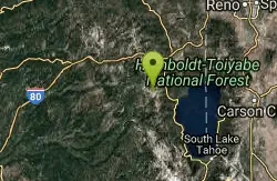
Truckee, California

| Address: | Soda Springs, CA 95728, USA |
| GPS: |
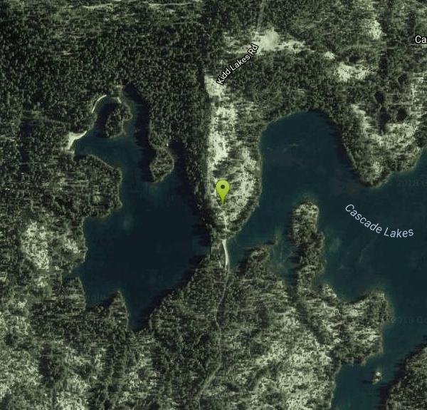
39°18'5.5"N 120°26'7.8"W Maps | Directions |
| State: | California |
| Trail Length: | 12.00 miles |
| Trail Type: | Out & Back |
| Hike Difficulty: | Advanced |
Lakes Rivers Waterfalls Trails Wildflowers
Hike and Swim
The Palisades Creek Trail is a difficult hike that can be done in a day, but is better enjoyed as an overnight trip. This trail has showcases some beautiful waterfalls along the way as well as excellent vista points of nearby mountain peaks. Much of the trail does cross into private lands, so please respect the rights of the landowners. At first the trial is a mild down hill trek, though after about two miles, the trail gets steeper. Along the way, hikers will have great views of Devils Peak as it stands above the Sierra Nevada treeline. They will also be able to pass by several lakes including Long lake and Cascade Lake. There are several ponds throughout the trail which can provide a water filling spot if hikers have packed filtration systems.
One of the must see spots along the trail is Palisade Falls or Heath Falls. This waterfall is one of the tallest along the American river, and is one of the first along the river. It is beautiful to look at, though can be a little tricky getting to. The trail hasn't been kept up over the years and so finding the specific trail to the waterfall might involve some exploring. The views of the waterfall are well worth the work, and if feeling adventurous, it makes a great swimming hole.
After this point, the trail becomes steep mountain switchbacks. The trail steadily gains in elevation, about 2,000 ft over three miles. Many people will turn back at this point, or make camp. Overall there is some really beautiful spots along this trail, and is best done when the snow has cleared from the roads, but the snowmelt is still flowing through the rivers and lakes.
More Information
Be courteous, informed, and prepared. Read trailhead guidelines, stay on the trail, and don't feed the wildlife.
Read More- Plan Ahead and Prepare
- Travel & camp on durable surfaces
- Dispose of waste properly
- Leave what you find
- Minimize campfire impacts
- Respect wildlife
- Be considerate of other visitors
Directions
From Truckee, California
- Head northwest toward Donner Pass Rd (66 ft)
- Turn left onto Donner Pass Rd (0.5 mi)
- At the traffic circle, take the 1st exit and stay on Donner Pass Rd (0.1 mi)
- Turn left to merge onto I-80 W toward Sacramento (11.7 mi)
- Take exit 174 toward Soda Springs/Norden (0.2 mi)
- Turn left onto Donner Pass Rd (0.8 mi)
- Turn right onto Soda Springs Rd (0.9 mi)
- Turn right onto Pahatsi Rd (0.4 mi)
- Continue onto Kidd Lakes Rd (3.8 mi)

Other Swimming Holes and Hiking Trails Nearby
Tahoe Area
Olympic Valley, California
11.2 miles SESwim near Olympic Valley, California
Swim
Shirley Canyon
Olympic Valley, California
12.0 miles SEHike near Olympic Valley, California
Hike 4.1 mi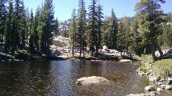
Shirley Lake Canyon Trail
Olympic Valley, California
12.6 miles SEShirley Lake is a pretty and pure lake located in Squaw Valley. The Shirley Lake Canyon Trail goes up into the rugged and lovely Sierra Mountains. You begin the trail in Squaw Valley Village and...
Hike, Swim
North Fork Falls
Colfax, California
13.4 miles WA very popular hike in the summer time, North Fork Falls offers a pleasant break from the city while enjoying the beautiful Sierra Nevada mountains. Hike into the forest and visitors will find a...
Camp, Hike, Swim 0.1 mi
Edwards Crossing
Nevada City, California
29.4 miles WEdwards Crossing is a popular and easily accessible swimming hole on the Yuba River. The swimming hole is named for Edwards Crossing Bridge which can be viewed from there. The river here is...
Hike, Swim 1.5 mi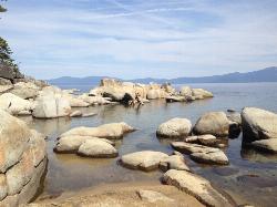
Skunk Harbor
Carson City, Nevada
29.6 miles SEThis hike starts from the 28 freeway and follows a forest service road. There are a couple of points where you can get some nice views from the trail. There are some mountain biking trails that can...
Hike
Zephyr Cove Park
Glenbrook, Nevada
33.2 miles SEZephyr Cove Park is located 4.6 miles off highway 50 in Nevada. This park is a great place to have your summer activities; it includes Picnic tables for groups and couples, Barbecue...
Camp, Canoe, Disc Golf, Hike, Horseback, Kayak, Swim 0.4 mi
Glen Alpine Falls
South Lake Tahoe, California
35.0 miles SEAs you drive up to the falls, take a look around. The views are spectacular. The drive can feel long, but the waterfall is peaceful and worth the drive. This waterfall is considered one of the...
Hike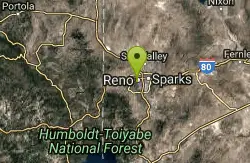
Reno Area
McGill, Nevada
36.4 miles NESwim near McGill, Nevada
Swim
Wingfield Park
Reno, Nevada
36.4 miles NEWingfield Park is a oasis of outdoor activity in the middle of bustling Reno. The park provides a variety of activities including swimming, white water kayaking,and river rafting, river tubing,...
Kayak, Swim 5.6 mi
Quarry Trail
Cool, California
41.4 miles SWThis is a hike along the river and an old, historic railway. The trail leads you to a a beautiful amphitheater carved from limestone.You are surrounded by beautiful nature and peaceful...
Hike 1.2-2.7 mi
Lake Clementine Trail Loop
Auburn, California
41.8 miles SWLocated in Auburn, California, Lake Clementine Trail Loop is a hike along the North Fork American River is an easy to moderate trail with an elevation gain of 785 ft. It's wheelchair...
Camp, Canoe, Hike, Kayak, Mountain Bike, SwimNearby Campsites
North Fork Falls
Colfax, California
13.4 miles WA very popular hike in the summer time, North Fork Falls offers a pleasant break from the city while enjoying the beautiful Sierra Nevada mountains. Hike into the forest and visitors will find a...
Camp, Hike, Swim
Zephyr Cove Park
Glenbrook, Nevada
33.2 miles SEZephyr Cove Park is located 4.6 miles off highway 50 in Nevada. This park is a great place to have your summer activities; it includes Picnic tables for groups and couples, Barbecue...
Camp, Canoe, Disc Golf, Hike, Horseback, Kayak, Swim 1.2-2.7 mi
Lake Clementine Trail Loop
Auburn, California
41.8 miles SWLocated in Auburn, California, Lake Clementine Trail Loop is a hike along the North Fork American River is an easy to moderate trail with an elevation gain of 785 ft. It's wheelchair...
Camp, Canoe, Hike, Kayak, Mountain Bike, Swim


