


112 Things to do near Blodgett Basin Trail No. 31
first prev 1 2 3 4 5 6 next lastShowing results within 50 miles Distance miles of Bull Pen Rd, Camp Verde, AZ 86322, USA City, Zip, or Address

Bullpen Day Use Area
Camp Verde, Arizona
0.2 miles WBullpen has something for everyone. Whether you park here and use the trail head to start on one of several hikes that lead down West Clear Creek, or stay nearby to use the picnic areas and...
Backpack, Dive, Hike, Swim 16.9 mi
West Clear Creek Trail No. 17
Camp Verde, Arizona
0.2 miles WWest Clear Creek Trail No. 17 is a great way to reach the running waters of West Clear Creek. By far the most accessible and popular, it starts from the Bull Pen Ranch parking lot and winds down the...
Backpack, Hike, Swim 0.4 mi
Clear Creek Campground
Camp Verde, Arizona
3.9 miles SWWest Clear Creek flows along the boundary of this desert canyon country camp and is a popular place for hiking, swimming, wading and fishing. Cool water species such as smallmouth bass and green...
Camp, Hike, Swim

Beaver Creek Campground
Camp Verde, Arizona
9.0 miles NCamp, Canoe, Kayak, and Swim near Camp Verde, Arizona
Camp, Canoe, Kayak, Swim 7.1 mi
The Crack at Wet Beaver Creek
Rimrock, Arizona
9.3 miles NThe Crack is a popular swimming hole found by hiking the Bell Trail down to Wet Beaver Creek. After following the trail for about 3.5 miles away from the parking lot, take a detour to the left just...
Dive, Hike, Horseback, Swim
Beaver Creek Dispersed Camping
9.4 miles N
Free dispersed camping on the cliffs above Beaver Creek.
Camp 1.1 mi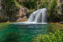
Fossil Creek Waterfall
Pine, Arizona
10.6 miles SEFossil Creek is one of Arizona's two designated "Wild and Scenic" rivers. The waterfall is the most popular place to visit to cool off and see the natural beauty. Located between...
Hike, Swim 2.2-6.1 mi
Fossil Creek Dam (Toilet Bowl)
Pine, Arizona
12.0 miles SEHidden within the vast Arizona desert is an oasis of a river that brings the surrounding banks to life around it. This is Fossil Creek--one of Arizona's two designated "Wild and...
Dive, Hike, Swim 0.1-3.8 mi
Fossil Springs Trail No. 18
Pine, Arizona
12.0 miles SELocated within the Fossil Springs Wilderness, this trail leads down a canyon to the springs for which it is named. At the trailhead, there are several hikes, some of which are available for...
Hike, Horseback, Swim
Verde Hot Springs
Camp Verde, Arizona
13.3 miles SVerde Hot Springs are a few natural hot spring pools located along the Verde River, near Sedona, Arizona. Once a resort, now all that remains are the foundations and the hot pools...
Camp, Hike, Hot Springs
Bearfoot Trail
Strawberry, Arizona
15.6 miles SEHike and Mountain Bike near Strawberry, Arizona
Hike, Mountain Bike 0.6-2.9 mi
Tramway Trail No. 32
Happy Jack, Arizona
16.1 miles ETramway Trail is a very short but very steep hike down the ridge of the Colorado Plateau to the nearby West Clear Creek. The trail crosses over the sharp edge of the Mogollan Rim, and descends to the...
Hike, Rock Climb, Swim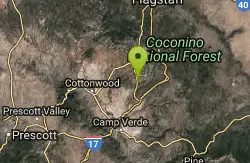
Cathedral Rock Trail
Sedona, Arizona
17.1 miles NStart off on the Bell Rock trail, go about 1.25 to 1.5 miles untill you locate the tunnel under Hwy 179 ( kinda hard to find without a map ). Go through the tunnel to start this fast...
Mountain Bike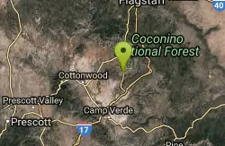
Slim Shady
Sedona, Arizona
17.3 miles NMeasuring 2.4 miles one-way, the Slim Shady trail forms the backbone of the Yavapai Point trail system and connects to Made in the Shade, Hiline, and more.
Mountain Bike 1.9 mi
Maxwell Trail No. 37
Happy Jack, Arizona
17.7 miles EThe Maxwell Trail leads over the Mongollan Rim down the canyon into West Clear Creek. Although still somewhat steep, it is an easier hike than shorter neighboring Tramway trail, which shares its...
Hike, Swim
Bell Rock Area Trails
Sedona, Arizona
17.7 miles NThe Bell Rock Area Trails is a trail system that extends from south of Courthouse Butte all the way up to the Little Horse Trail on the eastern side of Hwy 179. While this trail system...
Mountain Bike
Bell Rock Trailway
Sedona, Arizona
17.7 miles NThis 3.5 mile trail is smooth & wide and built for multiple user groups, its very popular with hikers and dog walkers. The main reason for posting it here is that it acts like a...
Mountain Bike
Made In The Shade
Sedona, Arizona
17.7 miles NThis is a singletrack connector that joins the Templeton Trail with the Village of Oak Creek. It is great either way but probably more fun from north to south. It has moderate climbs,...
Mountain Bike 0.1 mi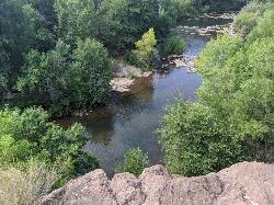
Mormons Crossing
Cornville, Arizona
18.0 miles NWMormons Crossing is a little area along Oak Creek in Cornville, Arizona. Along this creek there are several holes deep enough to swim in, some rapids, and even a rope swing. It's a great spot to...
Swim
Hiline
Sedona, Arizona
18.8 miles NHighline Trail is an expert-level mountain bike trail that is best ridden from the Village of Oak Creek side -- finishing on the Baldwin Trail loop. There is some exposure along the...
Mountain Bike


