


135 Things to do near Grand Prismatic Spring Overlook Trail
first prev 1 2 3 4 5 6 7 next lastShowing results within 50 miles Distance miles of 85PFG589+22 City, Zip, or Address

Yellowstone River Picnic Area Trail
Tower Junction, Yellowstone National Park
34.9 miles NEThe Yellowstone River Picnic Area trail is 3.9 miles loop trail. It is called the Yellowstone Picnic Area trail because the beginning of the trail is in a picnic area.This hike features a...
Hike 7.3 mi
Agate Creek Trail
Tower Junction, Wyoming
34.9 miles NEAgate Creek Trail is a moderately difficult trail through some of Yellowstone's most beautiful and isolated landscapes. This 7.3 mile hike starts at the Yellowstone River Picnic Area. Parking is...
Hike 16.9 mi
Specimen Ridge Trail (2K4)
Buffalo Ford, Wyoming
35.0 miles NESpecimen Ridge Trail is a challenging hike that requires navigational and technical skills to complete. This 17 mile hike is remote, and though it is marked by carins and blazes, it is often...
Hike
Cabin Creek
West Yellowstone, Montana
35.1 miles NWStarts out as a nice, buff trail. After a mile or two, there are a lot of tough creek crossings and when I rode it in 2010 there were a lot of trees down. This was from a recent...
Mountain Bike
Porcupine Creek
Ashton, Idaho
35.2 miles SWPorcupine Creek is a hunting, fishing, camping, and swimming spot near Ashton, Idaho in Fremont County within Targhee National Forest. It's surrounded by forests, meadows, and a creek...
Camp, Swim 7.9 mi
Rescue Creek Trail
Mammoth Hot Springs, Yellowstone National Park
35.4 miles NRescue Creek Trail is an 8 mile hike that crosses the Montana/Wyoming boarder. This double trail makes for a leisurely hike through beautiful hills and colorful yellow green grasslands. This trail,...
Hike
Sheep Falls on Henry's Fork
Island Park, Idaho
35.6 miles SWSheep Falls cascades approximately 25' through a narrow basalt chute on the North Fork of the Snake River near Island Park, Idaho. Compared to nearby Lower and Upper Mesa Falls, that height may...
Hike
Hellroaring Creek Trail
Yellowstone National Park
35.8 miles NEIf the name didn't scare you enough, the Hellroaring creek trail begins with an arduous descent down to the the Yellowstone River Suspension Bridge.The suspension bridge is a beautiful...
Camp, Hike, Swim
Sheep Creek Trail
36.1 miles NW
The trail has a few interesting spots (rocks, roots, etc.), but mostly it's pretty simple and straightforward. A pretty good climb, especially the last few hundred yards to the lake....
Mountain Bike
Warm River Campground
Ashton, Idaho
36.1 miles SWWarm River Campground is located nine miles northeast of Ashton, Idaho, along the slow-moving Warm River at an elevation of 5,200 feet. Willows line the riverbanks and pine trees offer partial...
Camp 3.2-47.0 mi
Yellowstone Branch Line Trail
Ashton, Idaho
36.2 miles SWYellowstone branch line trail runs from Warm River to the Montana border totaling 39 miles. There are a few places to jump on and off the trail as well as a few smaller trails that branch off of this...
Backpack, Cross-country Ski, Hike, Horseback, Mountain Bike 3.8 mi
Abandoned Railroad Bed Bike Trail
Gardiner, Montana
36.2 miles NThe Abandoned Railroad Bed Bike Trail, otherwise known as Shortline Trail, is a easily accessible bike trail found just inside the North Entrance of Yellowstone National Park. This bike trail follows...
Mountain Bike 4.0 mi

Specimen Ridge Day Hike and Fossil Forrest Trail
Buffalo Ford, Wyoming
36.9 miles NESpecimen Ridge Day Hike is a strenuous almost 4 mile trail to Specimen Ridge. This trail is rugged with a high elevation, and is not recommended for hikers with respiratory or heart...
Hike
Falls River, Lower Run
Ashton, Idaho
37.1 miles SWFall River rises on the Madison and Pitchstone plateaus in the southwest corner of Yellowstone National Park, Wyoming and flows approximately 64 miles (103 km) to its confluence with the Henrys Fork...
Whitewater 10.1 mi
Sky Rim Trail to Sheep Mountain
Big Sky, Montana
38.5 miles NSky Rim Trail to Sheep Mountain is a challenging hike with stunning and famous views. This 10 mile out-and-back trail starts at Dailey Creek Trailhead (WK1). The trail follows Dailey Creek over...
Backpack, Hike
Cliff Lake
Cameron, Montana
38.6 miles NWCanoe and Kayak near Cameron, Montana
Canoe, Kayak 8.5 mi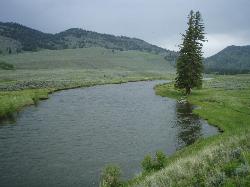
Slough Creek Trail
Tower Junction, Yellowstone National Park
39.2 miles NESlough Creek Trail is a 3.4 mile out and back trail that follows a historic wagon trail through several meadows. This trail is a fairly easy hike that has beautiful views of Slough Creek. The...
Hike
Ashton Hill
Ashton, Idaho
39.2 miles SWFairly thick forest. Considerable underbrush. Lots of places in the area to play.
Airsoft, Paintball
Big Bend Ridge Trail
Ashton, Idaho
39.4 miles SWTrail is open to OHVs. source: fs.usda.gov
Mountain Bike
Slough Creek Campground
Tower Junction, Yellowstone National Park
39.5 miles NESlough Creek campground is a small but very popular campground on the Northeast Entrance Road. Most of the campsites are situated right on the banks of Slough Creek where fishing is a favorite...
Camp


