


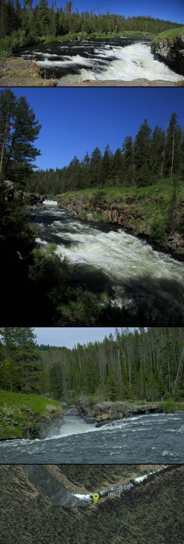
Sheep Falls on Henry's Fork
Island Park, Idaho

| Address: | ~Sheep Falls Rd, Ashton, ID 83420, USA |
| GPS: |
44°11'59.9"N 111°24'0.2"W Maps | Directions |
| State: | Idaho |
Hike
Sheep Falls cascades approximately 25' through a narrow basalt chute on the North Fork of the Snake River near Island Park, Idaho. Compared to nearby Lower and Upper Mesa Falls, that height may not sound particularly spectacular but it is a pleasant hike on a relatively well maintained trail and is rarely crowded.
More Information
Add ResourceBe courteous, informed, and prepared. Read trailhead guidelines, stay on the trail, and don't feed the wildlife.
Read More- Plan Ahead and Prepare
- Travel & camp on durable surfaces
- Dispose of waste properly
- Leave what you find
- Minimize campfire impacts
- Respect wildlife
- Be considerate of other visitors
Directions
From Island Park, Idaho
- Head south on Hwy 20 W toward Riverside Dr (17.3 mi)
- Turn left onto Sheep Falls Rd (2.4 mi)
- Turn left (0.2 mi)
From the Snake River bridge just north of Ashton, Idaho, travel 6.5 miles north on Highway 20. Turn east onto the Sheep Falls Road.
After turning east onto Sheep Falls Road drive 2.45 miles. This road is wide and well travelled and typically in good condition. In good weather 2WD cars will have no trouble on this section. The road winds around a bit and passes several turnoffs onto side roads. At 2.45 miles you'll reach a 4-way intersection, turn east (left). From here, you may need 4WD but if it doesn't look like your car will do it, find a good place to park and add 0.2mi to your hike (each way).


Other Hiking Trails Nearby

Mesa Falls
Ashton, Idaho
3.7 miles EUpper Mesa Falls, aka Big Falls, is an absolutely awesome waterfall on the Henrys Fork of the Snake River. The falls drop 114 ft. and measure 300 ft. across. To get to the falls from the parking lot...
Cross-country Ski, Hike, Kayak 0.3-0.6 mi
Bear Gulch
Ashton, Idaho
6.6 miles SEBear Gulch is an abandoned ski hill out of operation since 1969. While the vegetation is beginning to take over, there's still some great sledding to be had. It's just far enough into the...
Camp, Cross-country Ski, Hike, Sled 3.2-47.0 mi
Yellowstone Branch Line Trail
Ashton, Idaho
7.0 miles SEYellowstone branch line trail runs from Warm River to the Montana border totaling 39 miles. There are a few places to jump on and off the trail as well as a few smaller trails that branch off of this...
Backpack, Cross-country Ski, Hike, Horseback, Mountain Bike 0.6-4.7 mi
Harriman State Park
Island Park, Idaho
9.0 miles NHarriman State Park is found 38 miles from Yellowstone along Henry's Fork. This 11,000-acre wildlife refuge is open year round for most activities. In addition to having beautiful scenery and...
Cross-country Ski, Hike, Horseback, Mountain Bike, Snowshoe 0.8 mi
Conant Creek Pegram Truss Railroad Bridge
Ashton, Idaho
12.1 miles SAs part of the Rails to Trails project, this old railroad bridge has been transformed into a very safe little viewing experience for the whole family. You can drive right up to the bridge where there...
Hike 17.5 mi
Tear Drop Lake
Ashton, Idaho
13.5 miles ENestled in the Targhee National Forest just off of Ashton's Fish Creek Road, this tear drop shaped lake is a family adventure waiting to happen. The lake isn't very big but it is teeming with...
Camp, Canoe, Hike, Kayak, Mountain Bike, Swim 5.8 mi
Box Canyon Trail
Island Park, Idaho
14.8 miles NVarious species of tress and wildflowers can be seen on the trail, as well as songbirds, waterfowl and occasional wildlife. The trail is open for the following uses: Motorcycle Trail Riding, Off...
Hike, Mountain Bike 14.8-30.2 mi
Mr. Bubbles Hot Spring
Old Faithful, Yellowstone National Park
17.9 miles EMr. Bubbles is one of the few places you can actually soak in the thermal waters of Yellowstone National Park. The Bechler area of Yellowstone is one of the best kept secrets of the otherwise densely...
Hike, Hot Springs
Cave Falls of Yellowstone
Ashton, Idaho
20.3 miles EThis campgrond is situated on the banks of Fall River in Wyoming along the south border of Yellowstone National Park. Cave Falls Campground has 23 single site units and a terrific area for...
Camp, Hike
Bitch Creek Trestle
Tetonia, Idaho
21.1 miles SEAs part of the Rails to Trails project, this old railroad bridge has been transformed into a very safe little viewing experience for the whole family. You can drive right up to the bridge where...
Hike
Pine Butte / The Caldera
St. Anthony, Idaho
21.4 miles WThis is about as close to an oasis as you can get in the deserts of Idaho. It's an old volcano in the middle of the sagebrush desert. As soon as you start down the path, you can feel the air...
Camp, Hike, Horseback
Big Springs
Island Park, Idaho
21.8 miles NThere's also a great little walking trail along the river with placards that tell about the ecosystem and history of the area. There's about a 1/2 mile that's paved and then a 1/2 mile...
Camp, HikeHenry's Fork Green Way (St. Anthony Green Belt)
Saint Anthony, Idaho
21.9 miles SWThis is a great walk along the river. While it is nestled right next to the highway, the closeness and beauty of the river flowing on the other side of the trail more than make up for it. Halfway...
Hike 15.9-16.6 mi
Union Falls & Ouzel Pool
Grant Village, Yellowstone National Park
23.2 miles EBackpack, Hike, Hot Springs, and Swim near Grant Village, Yellowstone National Park
Backpack, Hike, Hot Springs, Swim 1.1 mi
Fish Lake
Ashton, Idaho
23.2 miles EHike near Ashton, Idaho
Hike 7.6 mi
Mount Jefferson
Island Park, Idaho
24.6 miles NMount Jefferson, at 10, 203 feet is the highest point in the Centennial Mountains, a small, local range on the border of Idaho and Montana a little west of Yellowstone. These mountains consist of a...
Hike 4.2 mi
Lake Marie
Island Park, Idaho
24.6 miles NLake Marie sits on the North slope of Mount Jefferson in Fremont County, Idaho. The trail to get there cuts back and forth across the Idaho Montana border 4 times. Much of the trail is fairly flat...
Backpack, Hike
Badger Creek
Tetonia, Idaho
26.5 miles SEBadger Creek is a stream located just 13.6 miles from Ashton, in Teton County, in the state of Idaho, United States, near France, ID. Whether you’re spinning, baitcasting or fly fishing your...
Camp, Cross-country Ski, Hike, Mountain Bike, Rock Climb 1.9 mi
Terraced Falls
Grant Village, Yellowstone National Park
27.8 miles E3.6 mile easy out and back trail. 430 ft Elevation gain. The trailhead is off Ashton-Flagg Ranch Road along Yellowstone's South border. Ashton-Flagg Ranch Road is closed during the winter.
Hike 0.6 mi
Packsaddle Lake
Tetonia, Idaho
29.6 miles SPacksaddle is one of the less well known lakes/trails in the area. If you've got a good offroad vehicle, you can probably make it all the way to the end of the road, otherwise, it's just an...
Dive, Hike, Mountain Bike, Snowshoe, SwimNearby Campsites
Bear Gulch
Ashton, Idaho
6.6 miles SEBear Gulch is an abandoned ski hill out of operation since 1969. While the vegetation is beginning to take over, there's still some great sledding to be had. It's just far enough into the...
Camp, Cross-country Ski, Hike, Sled
Warm River Campground
Ashton, Idaho
7.1 miles SEWarm River Campground is located nine miles northeast of Ashton, Idaho, along the slow-moving Warm River at an elevation of 5,200 feet. Willows line the riverbanks and pine trees offer partial...
Camp
Porcupine Creek
Ashton, Idaho
11.8 miles SEPorcupine Creek is a hunting, fishing, camping, and swimming spot near Ashton, Idaho in Fremont County within Targhee National Forest. It's surrounded by forests, meadows, and a creek...
Camp, Swim 17.5 mi
Tear Drop Lake
Ashton, Idaho
13.5 miles ENestled in the Targhee National Forest just off of Ashton's Fish Creek Road, this tear drop shaped lake is a family adventure waiting to happen. The lake isn't very big but it is teeming with...
Camp, Canoe, Hike, Kayak, Mountain Bike, Swim
Horseshoe Lake
Ashton, Idaho
15.0 miles EHorseshoe Lake is hidden back in the Targhee National Forest. It's a beautiful lake with plenty of lily pads. The road to get there is well maintained and there are many options for pull-outs...
Camp, Canoe, Dive, Swim 0.9 mi
Buffalo River Campground
Island Park, Idaho
15.9 miles NThe float here is nice and easy. It's a great early season float. Later in the season the shallow spots will force you to walk a good chunk of the float. The water is super clear and often pretty...
Camp, Canoe, Kayak, Swim
Sheep Falls on Fall River
Ashton, Idaho
17.4 miles SEThe lesser known Sheep Falls on Fall River is a local treasure off of Cave Falls road. There are primitive campsites and beautiful views for a great picnic spot. The water splits and comes down in...
Camp
Upper Coffee Pot Campground
Island Park, Idaho
20.2 miles NUpper Coffeepot Campground stretches along a floatable section of Henry's Fork of the Snake River. A mixed growth lodgepole pine forest provides partial shade and summer wildflowers are...
Camp, Canoe
Cave Falls of Yellowstone
Ashton, Idaho
20.3 miles EThis campgrond is situated on the banks of Fall River in Wyoming along the south border of Yellowstone National Park. Cave Falls Campground has 23 single site units and a terrific area for...
Camp, Hike
Pine Butte / The Caldera
St. Anthony, Idaho
21.4 miles WThis is about as close to an oasis as you can get in the deserts of Idaho. It's an old volcano in the middle of the sagebrush desert. As soon as you start down the path, you can feel the air...
Camp, Hike, Horseback
Big Springs
Island Park, Idaho
21.8 miles NThere's also a great little walking trail along the river with placards that tell about the ecosystem and history of the area. There's about a 1/2 mile that's paved and then a 1/2 mile...
Camp, Hike
Loon Lake
Ashton, Idaho
23.1 miles ECamp, Kayak, and Swim near Ashton, Idaho
Camp, Kayak, Swim
Badger Creek
Tetonia, Idaho
26.5 miles SEBadger Creek is a stream located just 13.6 miles from Ashton, in Teton County, in the state of Idaho, United States, near France, ID. Whether you’re spinning, baitcasting or fly fishing your...
Camp, Cross-country Ski, Hike, Mountain Bike, Rock Climb 4.8 mi
Aldous Lake and Hancock Lake
Kilgore, Idaho
30.4 miles NWA pair of alpine lakes near Kilgore, Idaho. Good road all the way to the trailhead. Easy to moderate 1.5mi hike to the first lake (Aldous) and another mile of moderate hiking to Hancock. Beautiful...
Backpack, Camp, Hike, Horseback, Swim 14.8 mi
Biscuit Basin to Fairy Falls and Firehole Meadows
Old Faithful, Yellowstone National Park
30.5 miles NEFreight Road trail is a almost 15 mile hike that leaves from Biscuit Basin or Fountain Flats Drive. This hike is a beautiful remote hike that passes several unique landmarks, breaking up this hike...
Backpack, Camp, Hike 0.1-0.5 mi
Eagle Park
Rexburg, Idaho
32.0 miles SWEagle Park is a little urban oasis. Once you drive in to this cottonwood forest along the river, you may forget that you're still inside Rexburg city limits. You can camp, picnic, throw rocks in...
Camp, Hike, Mountain Bike, Sled 0.8-1.3 mi
Warm Slough Campground
Rexburg, Idaho
32.5 miles SWThis is a pretty popular campsite that fills up pretty quick on busy weekends. Campsites are fairly spread out and there is no official donation box (as of July 2015). A couple of the campsites...
Airsoft, Camp, Canoe
Moody Meadows
Driggs, Idaho
36.0 miles SGood place for kids, they can ride bikes in the meadow, play in the stream, and camping is off of the road. Hiking, motorbiking, and horseback riding trails are abundant in the area.
Camp 0.5-3.5 mi
Webster's Dam
Ririe, Idaho
36.1 miles SAlso known as Manmade Falls or the Woodmansee Dam, Webster Dam is an abandoned dam located deep in Moody Creek canyon, the dam was abandoned when sediment built up behind the dam which then...
Camp, Hike, Mountain Bike
Beaver Dick Park
Rexburg, Idaho
36.1 miles SWBeaver Dick is a park 4.5 miles west of Rexburg, Idaho on Hwy 33. It's a 9.5 acre park that passes next to the west bank of the Henry Fork of the Snake River; it's a popular...
Camp, Canoe, Disc Golf, Swim


