


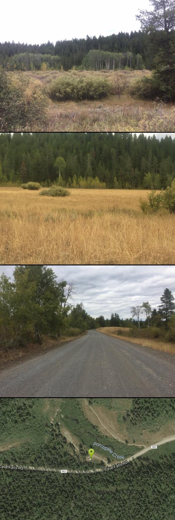
Porcupine Creek
Ashton, Idaho

| Address: | Cave Falls Road, Ashton, ID 83420, USA |
| GPS: |
44°5'15.7"N 111°13'11.0"W Maps | Directions |
| State: | Idaho |
Streams Fishing
Camp and Swim
Porcupine Creek is a hunting, fishing, camping, and swimming spot near Ashton, Idaho in Fremont County within Targhee National Forest. It's surrounded by forests, meadows, and a creek that you can explore and see various wildlife. There are trails nearby, however, none of them are marked trails. There's a few good spots to camp right here by a stream, but be aware that it is bear country, so use precaution and pack your food properly, or use the provided metal storage areas in the campsites.
Note: Porcupine Creek is closed to the public from November - March to protect wintering wildlife.
More Information
Add Resource- Plan Ahead and Prepare
- Travel & camp on durable surfaces
- Dispose of waste properly
- Leave what you find
- Minimize campfire impacts
- Respect wildlife
- Be considerate of other visitors
Directions
From Ashton, Idaho
- Head east on ID-47 N/Main St toward S 6th StContinue to follow ID-47 N(5.7 mi)
- Turn right onto E 1400 N/Cave Falls RdContinue to follow Cave Falls RdDestination will be on the left(6.5 mi)
Your GPS may try to take you to Porcupine Trail, but this is a private road. Be sure you have the accurate Porcupine Creek plugged in; in which you will enter Targhee National Forest and drive on a rocky, unpaved road for a few miles.


Other Swimming Holes Nearby

Horseshoe Lake
Ashton, Idaho
7.8 miles NEHorseshoe Lake is hidden back in the Targhee National Forest. It's a beautiful lake with plenty of lily pads. The road to get there is well maintained and there are many options for pull-outs...
Camp, Canoe, Dive, Swim 17.5 mi
Tear Drop Lake
Ashton, Idaho
10.5 miles NENestled in the Targhee National Forest just off of Ashton's Fish Creek Road, this tear drop shaped lake is a family adventure waiting to happen. The lake isn't very big but it is teeming with...
Camp, Canoe, Hike, Kayak, Mountain Bike, Swim
Loon Lake
Ashton, Idaho
13.5 miles ECamp, Kayak, and Swim near Ashton, Idaho
Camp, Kayak, Swim 15.9-16.6 mi
Union Falls & Ouzel Pool
Grant Village, Yellowstone National Park
13.9 miles EBackpack, Hike, Hot Springs, and Swim near Grant Village, Yellowstone National Park
Backpack, Hike, Hot Springs, Swim
Fall River Bridge
Ashton, Idaho
17.1 miles WRight off Highway 20, there's a great spot to swim, swing, and dive. There's pullouts for parking right next to the bridge. There's a rope swing under the railroad bridge and a little...
Dive, Swim
Twin Bridges
St. Anthony, Idaho
18.1 miles WThere's an old abandoned bridge next to the one currently in use. The water is pretty deep underneath and offers two distinct levels to jump from. There's a little rope swing under the bridge...
Dive, Swim
Fun Farm Bridge
Saint Anthony, Idaho
21.4 miles WAlso known as the Funny Farm Bridge, this is an excellent place for bridge jumping. You can jump from the road level, the top of the bridge, or swing from the bars below. Just be watchful of cars...
Dive, Swim
Hog Hollow Bridge
Saint Anthony, Idaho
22.1 miles SWLess than 1/2 a mile down the road from the Monkey Rock waterfall, Hog Hollow Bridge is a favorite spot for adrenaline junkies to cool off. The place to jump is off the East side of the bridge where...
Dive, Swim
Monkey Rock
Saint Anthony, Idaho
22.3 miles SWCLOSED. PSA: Monkey Rock is no longer open to the public. The owner has posted "No Trespassing" signs and is asking the Fremont County Sheriff's Office to assist with keeping people out of their...
Swim 0.6 mi
Packsaddle Lake
Tetonia, Idaho
22.5 miles SPacksaddle is one of the less well known lakes/trails in the area. If you've got a good offroad vehicle, you can probably make it all the way to the end of the road, otherwise, it's just an...
Dive, Hike, Mountain Bike, Snowshoe, Swim
St. Anthony Sandbar
Saint Anthony, Idaho
24.4 miles WCLOSED. //// Sand Bar Update //// ***As of 27 June 2019 *** The Sand Bar is still closed to ALL swimming, please do not cross the boundary line. We are closely monitoring the river flows...
Dive, Swim 0.9 mi
Buffalo River Campground
Island Park, Idaho
24.6 miles NThe float here is nice and easy. It's a great early season float. Later in the season the shallow spots will force you to walk a good chunk of the float. The water is super clear and often pretty...
Camp, Canoe, Kayak, Swim 3.6 mi
String Lake
Alta, Wyoming
32.1 miles SEString Lake is a shallow lake that connects Leigh Lake and Jenny Lake at the base of Mount St. John and Rockchuck Peak. From the lakeshore, you can also take in beautiful views of Teewinot and Mt....
Canoe, Hike, Kayak, Swim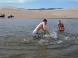
Egin Lakes
Saint Anthony, Idaho
33.0 miles WEgin Lakes is one of the favorite gateways to the St. Anthony Sand Dunes. The lakes themselves are unusually shallow and where you'll actually find a lake depends greatly on what time of the...
Sled, Swim
Beaver Dick Park
Rexburg, Idaho
38.7 miles SWBeaver Dick is a park 4.5 miles west of Rexburg, Idaho on Hwy 33. It's a 9.5 acre park that passes next to the west bank of the Henry Fork of the Snake River; it's a popular...
Camp, Canoe, Disc Golf, Swim 1.3-4.3 mi
Phelps Lake
Jackson, Wyoming
38.9 miles SEThe Phelps Lake trail, located in Teton National Park, Wyoming, is in one of the most scenic locations of the park. Usually overshadowed by nearby Jenny Lake, it can often be missed by visitors of...
Backpack, Camp, Dive, Hike, Swim
Jumping Rock at Phelp's Lake
Jackson, Wyoming
38.9 miles SEJust below Teton's Death Canyon, on the eastern shore of Phelp's Lake is a 20 foot boulder sitting all by itself above deep water. It's almost if God said, "Those hikers will need a...
Dive, Hike, Swim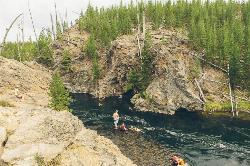
Firehole River
Madison, Yellowstone National Park
40.7 miles NEThe Firehole River starts south of Old Faithful, runs through the thermal areas northward to join the Gibbon and form the Madison River. The Firehole is world famous among anglers for its pristine...
Hot Springs, Swim 4.8 mi
Aldous Lake and Hancock Lake
Kilgore, Idaho
42.2 miles NWA pair of alpine lakes near Kilgore, Idaho. Good road all the way to the trailhead. Easy to moderate 1.5mi hike to the first lake (Aldous) and another mile of moderate hiking to Hancock. Beautiful...
Backpack, Camp, Hike, Horseback, Swim
Jefferson County Lake (AKA Rigby Lake)
Rigby, Idaho
43.4 miles SWRigby Lake has long been a favorite swimming hole for those in the area. The county has taken it well under its wing and made it a buzzing spot on any warm summer day. Along with the long standing...
Camp, Canoe, Dive, Kayak, Sled, SwimNearby Campsites

Warm River Campground
Ashton, Idaho
5.0 miles NWWarm River Campground is located nine miles northeast of Ashton, Idaho, along the slow-moving Warm River at an elevation of 5,200 feet. Willows line the riverbanks and pine trees offer partial...
Camp 0.3-0.6 mi
Bear Gulch
Ashton, Idaho
5.5 miles NWBear Gulch is an abandoned ski hill out of operation since 1969. While the vegetation is beginning to take over, there's still some great sledding to be had. It's just far enough into the...
Camp, Cross-country Ski, Hike, Sled
Sheep Falls on Fall River
Ashton, Idaho
6.4 miles EThe lesser known Sheep Falls on Fall River is a local treasure off of Cave Falls road. There are primitive campsites and beautiful views for a great picnic spot. The water splits and comes down in...
Camp
Horseshoe Lake
Ashton, Idaho
7.8 miles NEHorseshoe Lake is hidden back in the Targhee National Forest. It's a beautiful lake with plenty of lily pads. The road to get there is well maintained and there are many options for pull-outs...
Camp, Canoe, Dive, Swim 17.5 mi
Tear Drop Lake
Ashton, Idaho
10.5 miles NENestled in the Targhee National Forest just off of Ashton's Fish Creek Road, this tear drop shaped lake is a family adventure waiting to happen. The lake isn't very big but it is teeming with...
Camp, Canoe, Hike, Kayak, Mountain Bike, Swim
Cave Falls of Yellowstone
Ashton, Idaho
11.6 miles EThis campgrond is situated on the banks of Fall River in Wyoming along the south border of Yellowstone National Park. Cave Falls Campground has 23 single site units and a terrific area for...
Camp, Hike
Loon Lake
Ashton, Idaho
13.5 miles ECamp, Kayak, and Swim near Ashton, Idaho
Camp, Kayak, Swim
Badger Creek
Tetonia, Idaho
16.0 miles SBadger Creek is a stream located just 13.6 miles from Ashton, in Teton County, in the state of Idaho, United States, near France, ID. Whether you’re spinning, baitcasting or fly fishing your...
Camp, Cross-country Ski, Hike, Mountain Bike, Rock Climb 0.9 mi
Buffalo River Campground
Island Park, Idaho
24.6 miles NThe float here is nice and easy. It's a great early season float. Later in the season the shallow spots will force you to walk a good chunk of the float. The water is super clear and often pretty...
Camp, Canoe, Kayak, Swim
Reunion Flat Campground
Alta, Wyoming
26.5 miles SECamp near Alta, Wyoming
Camp
Teton Canyon Campground
Alta, Wyoming
27.4 miles SETeton Canyon is the start of several great adventures, including the Alaska Basin Trail, Table Rock, Devil's Stairs, and the Teton Crest. The campground offers a perfect basecamp to get an...
Camp 3.8-6.4 mi
Table Rock / Table Mountain
Driggs, Idaho
27.4 miles SEAt 11,300 feet, Table Mountain is possibly the most beautiful climb this side of the Tetons and offers what may well be the very best view of the Grand Tetons. It's just far enough away...
Camp, Hike
Big Springs
Island Park, Idaho
28.4 miles NThere's also a great little walking trail along the river with placards that tell about the ecosystem and history of the area. There's about a 1/2 mile that's paved and then a 1/2 mile...
Camp, Hike
Upper Coffee Pot Campground
Island Park, Idaho
28.8 miles NUpper Coffeepot Campground stretches along a floatable section of Henry's Fork of the Snake River. A mixed growth lodgepole pine forest provides partial shade and summer wildflowers are...
Camp, Canoe
Darby Canyon Camping
Alta, Wyoming
30.2 miles SThere's no official campgrounds up the canyon but there are several dispersed campsites with existing fire lays. Please adhere to principles of Leave No Trace. Use existing fire lays and leave...
Camp
Moody Meadows
Driggs, Idaho
30.7 miles SWGood place for kids, they can ride bikes in the meadow, play in the stream, and camping is off of the road. Hiking, motorbiking, and horseback riding trails are abundant in the area.
Camp 14.8 mi
Biscuit Basin to Fairy Falls and Firehole Meadows
Old Faithful, Yellowstone National Park
31.0 miles NEFreight Road trail is a almost 15 mile hike that leaves from Biscuit Basin or Fountain Flats Drive. This hike is a beautiful remote hike that passes several unique landmarks, breaking up this hike...
Backpack, Camp, Hike
Pine Butte / The Caldera
St. Anthony, Idaho
32.2 miles WThis is about as close to an oasis as you can get in the deserts of Idaho. It's an old volcano in the middle of the sagebrush desert. As soon as you start down the path, you can feel the air...
Camp, Hike, Horseback 0.1 mi
Lewis Lake Campground
Grant Village, Yellowstone National Park
32.2 miles NELewis Lake is located in the southern part of Yellowstone National Park. It is 4 miles southeast of Shoshone Lake. Lewis Lake offers a plethora great water activities. This lake offers...
Camp, Canoe, Kayak 0.5-3.5 mi
Webster's Dam
Ririe, Idaho
33.0 miles SWAlso known as Manmade Falls or the Woodmansee Dam, Webster Dam is an abandoned dam located deep in Moody Creek canyon, the dam was abandoned when sediment built up behind the dam which then...
Camp, Hike, Mountain Bike


