


242 Things to do near River Rush
first prev 3 4 5 6 7 8 9 10 11 12 next lastShowing results within 50 miles Distance miles of 3242 E 1300 N, Ashton, ID 83420, USA City, Zip, or Address

Burns Canyon
Ririe, Idaho
32.2 miles SHike and Mountain Bike near Ririe, Idaho
Hike, Mountain Bike
Jefferson County Lake (AKA Rigby Lake)
Rigby, Idaho
32.3 miles SWRigby Lake has long been a favorite swimming hole for those in the area. The county has taken it well under its wing and made it a buzzing spot on any warm summer day. Along with the long standing...
Camp, Canoe, Dive, Kayak, Sled, Swim 0.6-5.5 mi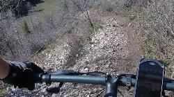
Old Ranger
Ririe, Idaho
32.3 miles SOn the South end of the Big Hole mountains just above the Snake River is a grueling yet diverse section of single-track on Forest Service Trail 287 called Old Ranger. Because of the...
Mountain Bike 2.7 mi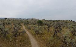
Sidewinder Trail
Ririe, Idaho
32.6 miles SSidewinder's claim to fame is that it's on a South facing hill just above the Snake River. That means that when all the other trails in the Kelly Canyon Trail network are covered with snow...
Mountain Bike 3.8 mi
Stinking Springs
Ririe, Idaho
32.6 miles SStinking Springs is a great early to late season trail. Being at the edge of the Big Hole range, it gets spring earlier and winter later than other trails in the range. It's closed from December...
Hike, Mountain Bike

Wolf Flats Recreation Area
Ririe, Idaho
33.0 miles SWolf Flats is a completely free, dispersed, undeveloped camping area with 25 locations to camp. Some areas are large enough to accommodate groups of 50 people.
Camp
Grand Targhee Resort
Moose, Wyoming
33.1 miles SESpectacular Teton mountain course at 8000' elevation. Discs in Activity Center. Head bartender in resort's Trap Bar is the course pro. Course open when snow is gone; usually June to...
Disc Golf 1.9 mi
Terraced Falls
Grant Village, Yellowstone National Park
33.1 miles E3.6 mile easy out and back trail. 430 ft Elevation gain. The trailhead is off Ashton-Flagg Ranch Road along Yellowstone's South border. Ashton-Flagg Ranch Road is closed during the winter.
Hike
Cold Springs
Moose, Wyoming
33.1 miles SETrail is easiet down as a loop but can be done as a shuttle as well. Take a right into Teton Canyon and park at the first big parking lot on the left. About 50 yards from Ski Hill rd....
Mountain Bike 0.3 mi
Pointless Crag
Ririe, Idaho
33.1 miles SNO MORE BOLTING as of 5/2012 requested by the Bureau of Land Management. The BLM has asked us NOT to park on the road below the cliff. Please use the obvious parking area next to the river...
Rock Climb
Henderson Canyon
Victor, Idaho
33.2 miles SETrail begins as dirt road/double track with numerous "cow" trails breaking off of road. Some of these trails see more tire tracks than others.
Mountain Bike
South Park
Ririe, Idaho
33.3 miles SRock Climb near Ririe, Idaho
Rock Climb
Blacks Canyon Trail
Ririe, Idaho
33.4 miles SThe Blacks Canyon trail begins at Black Can Road and ends at Junction Fleming Canyon Trail. The trail is open for the following uses: Motorcycle Trail Riding, Off Highway Vehicles (OHV)...
Mountain Bike
South Fork Rim Trail
Ririe, Idaho
33.4 miles SMotorcycle trail. source: fs.usda.gov Courtesy of Singletracks.com
Mountain Bike 1.7 mi
Rick's Basin
Driggs, Idaho
33.5 miles SEMountain Bike near Driggs, Idaho
Mountain Bike
Spring Creek Trail
Alta, Wyoming
33.6 miles SEThis trail starts at the remains of the historic Rapid Creek Ranger Station. The trail heads east following an old road. After crossing Rapid Creek, the trail climbs up to a ridge...
Mountain Bike 7.6 mi
Mount Jefferson
Island Park, Idaho
33.6 miles NMount Jefferson, at 10, 203 feet is the highest point in the Centennial Mountains, a small, local range on the border of Idaho and Montana a little west of Yellowstone. These mountains consist of a...
Hike 4.2 mi
Lake Marie
Island Park, Idaho
33.6 miles NLake Marie sits on the North slope of Mount Jefferson in Fremont County, Idaho. The trail to get there cuts back and forth across the Idaho Montana border 4 times. Much of the trail is fairly flat...
Backpack, Hike
Sawtell Peak Trail
Island Park, Idaho
33.6 miles NThis trail offers great views of the valley floor, mountain peaks and wildlife. source: fs.usda.gov
Mountain Bike 7.1 mi
Mill Creek Trail
Moose, Wyoming
33.7 miles SEThere are two ways to do this ride, one as a loop with the Targhee road providing the bulk of the climb, or as an out and back (up the trail and back down). Keep in mind that this trail is...
Cross-country Ski, Mountain Bike, Snowshoe


