


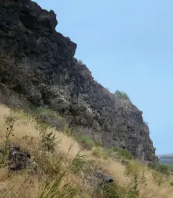
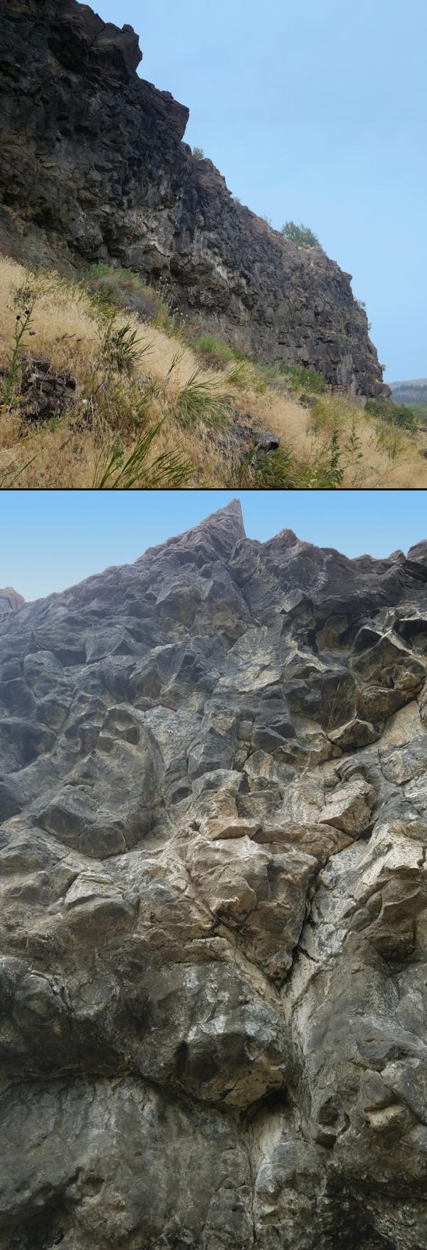
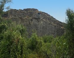
Pointless Crag
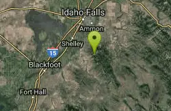
Ririe, Idaho
| Address: | 5436 E Heise Rd, Ririe, ID 83443, USA |
| GPS: |
43°36'2.3"N 111°38'37.0"W Maps | Directions |
| State: | Idaho |
| Trails/Routes: | 0.3 mi |
Rock Climb
Courtesy of Dean Lords, Route Setter deanlords.blogspot.com
- NO MORE BOLTING as of 5/2012 requested by the Bureau of Land Management.
- The BLM has asked us NOT to park on the road below the cliff. Please use the obvious parking area next to the river before reaching the cliff. The parking area is 2.7 miles up the South Fork Rd on the right from where you turn off of the Ski Hill Road.
- Some of the 1st bolts are high off the ground and require climbing through suspect rock to clip. PLEASE don't trust the stone and protect yourself by clipping the first bolt from the ground with a stick clip.
- Many top anchors are equipped with carabiners for convenience and safety with these short routes. They are not yours to take home! Use them for lowering only. If you are going to top-rope or run lead laps, please use your own quickdraws at the anchors until the last lap, then lower off the fixed biners.
- The rock on most routes is suspect and the climber is not responsible for maintaining awareness of all persons on the ground. If you get whacked by falling rock, it's your own fault. Belay, cheer, observe, socialize in a safe place. Take it seriously and speak up if you see someone in harms way. The climber isn't looking out for your safety... you are. Take it seriously. Serious.
- Rattlesnakes, ticks, and mosquito's. Nothing more needs to be said.
Routes from Left to Right
| Route | Difficulty |
| Black Betty | 5.12b |
| 50 yard gap | |
|---|---|
| Head on a Silver Platypus | 5.10a |
| Sleepwalker | 5.10d |
| 4-Alarm Fire | 5.10b |
| Hoppe Hill | 5.10c |
| Hustle and Flow | 5.12d |
| Goat Meal | 5.11a |
| Hungry Eyes | 5.9 |
| Stingray | 5.10c/d |
| 30 yard gap | |
| Orbit | 5.11a |
| 20 yard gap | |
| Rock-in My Sports Bra | 5.9 |
| Disappearing Hat Trick | 5.10a |
| Lords-a-Leaping (AKA 5.7 Crack) | 5.7 |
| Black Bear | 5.12a |
| What's the Point? | 5.11b |
| 11 O'clock | 5.10a |
| Team Trailer | 5.8 |
| The Bicycle Thief | 5.10a |
| Alien Pod | 5.7 |
The routes are marked on the map but are not the exact GPS. They are in the right order and should get you fairly close to the right routes.
More Information
identifier?continue=https%3A%2F%2Fwww.blogger.com%2Fblogin.g%3FblogspotURL%3Dhttp%3A%2F%2Fdeanlords.
https://accounts.google.com/v3/signin/identifier?continue=https%3A%2F%2Fwww.blogger.com%2Fblogin.g%3FblogspotURL%3Dhttp%3A%2F%2Fdeanlords.blogspot.com%2Fp%2Fpointless-crag.html%26type%3Dblog%26zx%3Duj3m4k5rz5ps&hl=en-US&ifkv=ARZ0qKI17eOTYwVPKvM9MwsDkf_29DIS4kJpC67Q5L0caw3JXitiGkSpXLwcz-WwdDYvB9ZD-GzRock Climbing in Pointless Crag, East Idaho
Find rock climbing routes, photos, and guides for every state, along with experiences and advice from fellow climbers.
https://www.mountainproject.com/area/107690641/pointless-crag- Plan Ahead and Prepare
- Travel & camp on durable surfaces
- Dispose of waste properly
- Leave what you find
- Minimize campfire impacts
- Respect wildlife
- Be considerate of other visitors
Directions
From Ririe, Idaho
- Head east on Smith St toward 1st E St (0.3 mi)
- Continue onto Archer Rd (1.6 mi)
- Turn right onto E 200 N/Heise Rd/Poplar Loop (0.9 mi)
- Slight right onto Heise Rd/Poplar Loop (0.2 mi)
- Continue straight onto N 4800 E/Heise Rd/Poplar LoopContinue to follow Heise Rd/Poplar Loop(2.9 mi)
- Slight left onto E 100 N/Heise Rd/Poplar Loop (187 ft)
- Slight left onto N 5050 E (0.4 mi)
- Turn right onto E Heise Rd (2.3 mi)
- Turn right to stay on E Heise RdDestination will be on the left(2.6 mi)
A climbers trail directly across from the parking lot leads to the west end of the climbing area and is marked with a small pile of river rocks. This trail will likely flood for a portion of the spring season. A second trail (the original) is located on the east end of the cliff and can be reached from the parking lot by walking east (up river) on the road for a couple hundred yards. If you get to the orange wall, you've gone too far.Courtesy of Dean Lords, Route Setter deanlords.blogspot.com


Other Rock Climbing Walls Nearby
South Park
Ririe, Idaho
0.7 miles SERock Climb near Ririe, Idaho
Rock Climb
Paramount Wall / Blanche Rock
Ririe, Idaho
2.7 miles NA sport climbing wall above the road near Ririe with great exposure, afternoon shade, and well-loved 5.9–5.10 lines — most routes work with a 50-meter rope, established by Chuck Oddette and crew.
Camp, Horseback, Rock Climb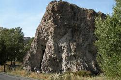
Heise Rock (AKA Elephant Rock)
Ririe, Idaho
2.9 miles NWCLOSED. Rock climbing is no longer permitted. A volcanic plug sport climbing crag near Heise Hot Springs with lines developed since the late 1980s — great potential across the south side, with routes across all skill levels.
Rock Climb
Blacktail Day Use Area
Ririe, Idaho
5.0 miles WCliff jumping from almost nothing up to 80 feet, plus rock climbing routes, on the north end of Ririe Reservoir — $3–$5 daily fee applies.
Dive, Rock Climb, Swim
The Arcane
Ririe, Idaho
6.5 miles EThe Arcane is a rugged rock-climbing crag in the canyon country of eastern Idaho, up the South Fork Snake River drainage past Heise and the Kelly Canyon area, roughly 23 miles from Idaho Falls. A...
Rock Climb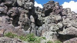
Basalt Bluff / Steve's Rock
Teton, Idaho
17.0 miles NA basalt crag with 11 established sport climbing routes ranging from 5.8 to 5.10+ — rappel off with two ropes or walk off to the north, but watch for attack bees at the top.
Rock Climb
RPM Wall
Firth, Idaho
26.9 miles SWWolverine Canyon is full of limestone. The RPM wall being the currently developed wall and has some decent routes.
Rock Climb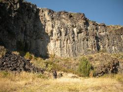
The Playground
Shelley, Idaho
30.8 miles SWA moderate-to-hard basalt sport climbing wall east of Idaho Falls with nine routes from 70 to 80 feet — including classics like 'Tied to the Whipping Post' and 'Anchored to the Sky,' best April through September.
Rock Climb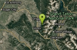
Darby Canyon Cliffs
Alta, Wyoming
31.5 miles EA popular west-slope hike near Alta, Wyoming to an ancient Wind Cave snaking through 350-million-year-old dolomite, with waterfalls and wildflowers cascading down the canyon rim along the way.
Rock Climb 6.2 mi
Darby Wind Cave
Driggs, Idaho
34.2 miles EWaterfalls, wildflowers, creek crossings, and a wind cave high on the canyon wall — Darby's switchback trail rewards hikers with views found nowhere else in the Tetons.
Backpack, Cave, Hike, Rock Climb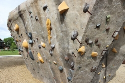
Phil Baux Park
Jackson, Wyoming
45.2 miles EA neighborhood park with playground basics plus the Teton Boulder Project — three 12-foot natural-style rock climbing structures with routes from beginner to advanced, alongside a mountain memorial.
Rock Climb 3.9-14.4 mi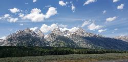
Grand Teton
Jackson Hole, Wyoming
46.0 miles EAt 13,770 feet, the Grand Teton towers over Western Wyoming — all popular routes require rock climbing gear and are for skilled climbers only, with 3,000 feet of exposure where a fall is fatal.
Backpack, Hike, Rock Climb 13.8 mi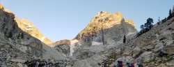
Middle Teton
Jackson Hole, Wyoming
46.0 miles EThe 12,804-ft Middle Teton rewards serious alpinists with glacier bouldering through the Southwest Couloir and panoramic views of the Grand, South, and surrounding Tetons.
Backpack, Hike, Rock ClimbNearby Campsites

Wolf Flats Recreation Area
Ririe, Idaho
1.6 miles EWolf Flats is a completely free, dispersed, undeveloped camping area with 25 locations to camp. Some areas are large enough to accommodate groups of 50 people.
Camp
Kelly Island Campground
Ririe, Idaho
1.9 miles NWA BLM campground with 14 family sites and 1 group site for RVs or tents, open May through September — vault toilets, pets welcome, and rates from $5–$20 per night.
Camp
Paramount Wall / Blanche Rock
Ririe, Idaho
2.7 miles NA sport climbing wall above the road near Ririe with great exposure, afternoon shade, and well-loved 5.9–5.10 lines — most routes work with a 50-meter rope, established by Chuck Oddette and crew.
Camp, Horseback, Rock Climb
Table Rock Campground
Ririe, Idaho
3.4 miles NEA campground in Caribou-Targhee National Forest — part of a 3-million-acre stretch from Montana to the Utah and Wyoming borders — with access to the Curlew National Grassland.
Camp
Big Hole Dispersed Campsites
Ririe, Idaho
5.3 miles NA network of dispersed campsites with fire rings in the Big Hole mountains above Kelly Canyon — first come, first served, no reservations, and Leave No Trace principles are essential.
Camp 0.5-3.5 mi
Webster's Dam
Ririe, Idaho
7.0 miles NAn abandoned dam in Moody Creek canyon where sediment split the stream into two beautiful 15-foot waterfalls — stunning in spring runoff and blazing with fall colors.
Camp, Hike, Mountain Bike
Twin Bridges Park
Rexburg, Idaho
7.9 miles NWA 27-acre Snake River park between two bridges near Rexburg with shaded campsites, fire pits, pavilions, a playground, and BLM ground for hiking and hunting on three sides.
Camp, Canoe
Moody Meadows
Driggs, Idaho
10.5 miles NEGood place for kids, they can ride bikes in the meadow, play in the stream, and camping is off of the road. Hiking, motorbiking, and horseback riding trails are abundant in the area.
Camp
Jefferson County Lake (AKA Rigby Lake)
Rigby, Idaho
14.6 miles NWSandy beaches, two floating docks with a slide, volleyball, playgrounds, and a safe swim zone — Jefferson County Lake is eastern Idaho's go-to summer swimming spot.
Camp, Canoe, Dive, Kayak, Sled, Swim
Fall Creek Falls
Swan Valley, Idaho
17.3 miles SEA shaded Snake River campground near Swan Valley with abundant wildlife, great trout fishing, and Fall Creek Falls a quarter-mile away.
Camp, Cave, Hike, Kayak, Swim 0.2-0.5 mi
Eagle Park
Rexburg, Idaho
18.0 miles NWA cottonwood forest park inside Rexburg city limits with campsites, fishing, a dog park, mountain biking on easy and moderate loops, and rock-throwing by the river.
Camp, Hike, Mountain Bike, Sled
Falls Campground
Victor, Idaho
18.3 miles SEA Snake River campground near Swan Valley with cottonwood shade, abundant wildlife — eagles, osprey, moose, and deer — and Fall Creek Falls just a quarter mile away; Palisades Reservoir is 20 miles out.
Camp
Beaver Dick Park
Rexburg, Idaho
20.3 miles NWA 9.5-acre Snake River park near Rexburg with fire pits, pavilions, fishing, boating, swimming, and a rich history tied to legendary frontiersman Beaver Dick Leigh.
Camp, Canoe, Disc Golf, Swim 0.6-2.0 mi
North Menan Butte ('R' Mountain)
Menan, Idaho
21.5 miles NWA volcanic butte locals call R Mountain, with a paved trailhead, chain handrails near the top, informational signs at the rim, and views of Rexburg and the Snake River.
Camp, Cave, Hike 0.8-1.3 mi
Warm Slough Campground
Rexburg, Idaho
21.8 miles NWA popular river campground with two boat ramps and an easy, slow-moving inner tube float — the take-out is 1,000 feet from the put-in, making multiple runs a breeze.
Airsoft, Camp, Canoe
Pine Creek Campground
Victor, Idaho
22.0 miles EThe Pine Creek Campground has 10 single units and has restrooms.
Camp 2.8-4.1 mi
Palisades Creek Trail / Lakes and Waterfall Canyon
Irwin, Idaho
25.8 miles SESpectacular mountain views, two landslide-formed alpine lakes, and mountain goat sightings — all within a 4-to-6-mile hike in the Swan Valley wilderness.
Backpack, Camp, Hike, Horseback, Mountain Bike
Sealander Park
Idaho Falls, Idaho
28.5 miles SWA peaceful 15-acre park steeped in Idaho homesteader history — listed on the National Register of Historic Places, Sealander Park is available to reserve for picnics, reunions, weddings, and retreats.
Camp
Calamity Campground
Irwin, Idaho
28.7 miles SEA wooded Palisades Reservoir campground 55 miles east of Idaho Falls with clean blue water for swimming, boating, water skiing, and fishing — plus miles of ATV routes.
Camp, Canoe, Hike, Kayak, Mountain Bike, Swim
Mike Harris Campground
Victor, Idaho
28.9 miles EA scenic mountain campground at 6,200 feet along Teton Pass just 5 miles from Victor, Idaho — a peaceful base for fishing, trail exploring, and sightseeing in the Teton region.
Camp


