


222 Things to do near Spring Creek Trail
first prev 1 2 3 4 5 6 7 8 9 10 next lastShowing results within 50 miles Distance miles of 2150 Rapid Creek Rd, Alta, WY 83414, USA City, Zip, or Address

Packsaddle Lake
Tetonia, Idaho
15.5 miles WPacksaddle is one of the less well known lakes/trails in the area. If you've got a good offroad vehicle, you can probably make it all the way to the end of the road, otherwise, it's just an...
Dive, Hike, Mountain Bike, Snowshoe, Swim 3.6 mi
String Lake
Alta, Wyoming
15.8 miles EString Lake is a shallow lake that connects Leigh Lake and Jenny Lake at the base of Mount St. John and Rockchuck Peak. From the lakeshore, you can also take in beautiful views of Teewinot and Mt....
Canoe, Hike, Kayak, Swim 24.3 mi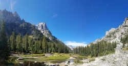
Cascade Canyon Trail
Jackson Hole, Wyoming
15.8 miles EThis hike starts the same as the Jenny Lake trail, then after you pass the boat dock, it takes off up Cascade Canyon just to the north of Teewinot, Mount Owen, and the Grand Teton along Cascade...
Backpack, Hike
Jenny Lake Campground
Jackson Hole, WY
15.8 miles EJenny Lake campground is a scenic beauty in the heart of Grand Teton National Park. It's understandable why it often fills before 8 AM during peak summer periods. It's nestled right at the...
Camp 0.1-7.3 mi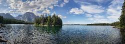
Leigh Lake
Alta, Wyoming
15.9 miles EEnjoy the grandeur of Grand Teton National Park just a little ways off the beaten path. Leigh Lake rests underneath the majestic Mount Moran. The waters of Leigh Lake flow almost directly into String...
Backpack, Canoe, Hike, Kayak 10.5-16.2 mi
Paintbrush Canyon
Alta, Wyoming
16.0 miles EBeautiful trail along String Lake, Leigh Lake, and Lake Solitude. For even more solitude, scramble up the rocks to Micah Lake for a beautiful view and even fewer people. You won't find...
Backpack, Hike
Fuzzy Bunny/Power Line Jumps/Parallel
Wilson, Wyoming
16.6 miles SThis is a steep, fast, rugged downhill trail with some freeride features that are also "ride-around-able." At the end of Fuzzy Bunny, look for Power Line Jumps off the Old Pass Road...
Mountain Bike
Bitch Creek Trestle
Tetonia, Idaho
16.7 miles NAs part of the Rails to Trails project, this old railroad bridge has been transformed into a very safe little viewing experience for the whole family. You can drive right up to the bridge where...
Hike
Phillips Ridge
Wilson, Wyoming
17.3 miles STrail is recommend to be done as a shuttle but can be done as an out and back from trailhead on Fish Creek Road. Shuttle is easiest by parking a vehicle and the Stagecoach bar or the...
Mountain Bike
Black Canyon
Wilson, Wyoming
17.3 miles STrail starts at the parking lot ontop of the pass. Take the service road on the west side of the parking lot. The road will turn into singletrack when you reach a service building...
Mountain Bike
West Pine Creek Trail
Ririe, Idaho
17.4 miles SWNon-motorized use. source: fs.usda.gov
Mountain Bike
Trail Canyon Trail
Ririe, Idaho
17.4 miles SWThe Trail Canyon trail begins at Trail Canyon Parklot, T8s R43e Sec28 and ends at Intersect Trail 5251,t8s R43e Sec28. source: fs.usda.gov
Mountain Bike
Wright Creek Trail
Tetonia, Idaho
17.9 miles WOpen to MTB, horseback riding, snowshoeing, and hiking. source: fs.usda.gov
Mountain Bike
Thousand Springs Trail
Driggs, Idaho
19.6 miles WThe Thousand Springs trail begins at Moody Swamp trailhead and ends at Jct Prospect Peak Trail. source: fs.usda.gov Courtesy of Singletracks.com
Mountain Bike
North/South Rainey Creek Trails
Irwin, Idaho
20.3 miles SWMotorcycle trail. source: fs.usda.gov
Mountain Bike

Moody Meadows
Driggs, Idaho
21.6 miles WGood place for kids, they can ride bikes in the meadow, play in the stream, and camping is off of the road. Hiking, motorbiking, and horseback riding trails are abundant in the area.
Camp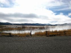
Kelly Warm Spring
Kelly, Wyoming
21.9 miles EThese are more of a warm spring but it's still a pretty good soak and with a beautiful view of the Tetons from the Jackson Hole side.
Hot Springs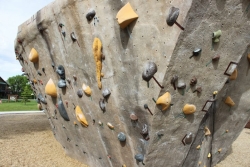
Phil Baux Park
Jackson, Wyoming
22.2 miles SEPhil Baux park has your typical park equipment such as a playground, swing set, small picnic shelter, 8 picnic tables, horseshoe pits and plenty of green grass for other recreational...
Rock Climb
South Fork Rim Trail
Ririe, Idaho
23.0 miles SWMotorcycle trail. source: fs.usda.gov Courtesy of Singletracks.com
Mountain Bike
Blacks Canyon Trail
Ririe, Idaho
23.0 miles SWThe Blacks Canyon trail begins at Black Can Road and ends at Junction Fleming Canyon Trail. The trail is open for the following uses: Motorcycle Trail Riding, Off Highway Vehicles (OHV)...
Mountain Bike


