


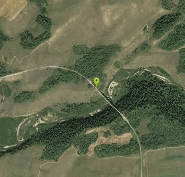
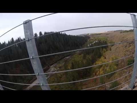
Bitch Creek Trestle
Tetonia, Idaho

| Address: | ~1575 North 260 West, Tetonia, ID 83452, USA |
| GPS: |
43°57'9.3"N 111°9'6.2"W Maps | Directions |
| State: | Idaho |
Hike
As part of the Rails to Trails project, this old railroad bridge has been transformed into a very safe little viewing experience for the whole family. You can drive right up to the bridge where there is a great little spot to park. Bitch Creek meeanders hundreds of feet below the bridge.
The bridge is part of the 30 mile Ashton-Tetonia Trail. Conant Creek Pegram Truss Railroad Bridge is further down the same trail.
Difficulty: Beyond easy
More Information
Add ResourceBe courteous, informed, and prepared. Read trailhead guidelines, stay on the trail, and don't feed the wildlife.
Read More- Plan Ahead and Prepare
- Travel & camp on durable surfaces
- Dispose of waste properly
- Leave what you find
- Minimize campfire impacts
- Respect wildlife
- Be considerate of other visitors
Directions
From Tetonia, Idaho
- Head north on ID-33 W/S Main St toward Central AveContinue to follow ID-33 W(1.6 mi)
- Turn right onto ID-32 (8.8 mi)
- Keep right to continue toward 4925 E (0.2 mi)
- Turn right onto 4925 E (0.7 mi)
- Turn right onto 550 N (0.7 mi)
- Keep right (135 ft)
- Turn rightDestination will be on the right(1.0 mi)
Other Hiking Trails Nearby

Badger Creek
Tetonia, Idaho
6.3 miles SBadger Creek is a stream located just 13.6 miles from Ashton, in Teton County, in the state of Idaho, United States, near France, ID. Whether you’re spinning, baitcasting or fly fishing your...
Camp, Cross-country Ski, Hike, Mountain Bike, Rock Climb 0.8 mi
Conant Creek Pegram Truss Railroad Bridge
Ashton, Idaho
11.9 miles NWAs part of the Rails to Trails project, this old railroad bridge has been transformed into a very safe little viewing experience for the whole family. You can drive right up to the bridge where there...
Hike 3.2-47.0 mi
Yellowstone Branch Line Trail
Ashton, Idaho
14.1 miles NWYellowstone branch line trail runs from Warm River to the Montana border totaling 39 miles. There are a few places to jump on and off the trail as well as a few smaller trails that branch off of this...
Backpack, Cross-country Ski, Hike, Horseback, Mountain Bike 14.8-30.2 mi
Mr. Bubbles Hot Spring
Old Faithful, Yellowstone National Park
14.6 miles NMr. Bubbles is one of the few places you can actually soak in the thermal waters of Yellowstone National Park. The Bechler area of Yellowstone is one of the best kept secrets of the otherwise densely...
Hike, Hot Springs
Cave Falls of Yellowstone
Ashton, Idaho
15.2 miles NEThis campgrond is situated on the banks of Fall River in Wyoming along the south border of Yellowstone National Park. Cave Falls Campground has 23 single site units and a terrific area for...
Camp, Hike 0.3-0.6 mi
Bear Gulch
Ashton, Idaho
15.3 miles NWBear Gulch is an abandoned ski hill out of operation since 1969. While the vegetation is beginning to take over, there's still some great sledding to be had. It's just far enough into the...
Camp, Cross-country Ski, Hike, Sled 0.6 mi
Packsaddle Lake
Tetonia, Idaho
15.5 miles SWPacksaddle is one of the less well known lakes/trails in the area. If you've got a good offroad vehicle, you can probably make it all the way to the end of the road, otherwise, it's just an...
Dive, Hike, Mountain Bike, Snowshoe, Swim 4.5 mi
Sheep Bridge Trail
Driggs, Idaho
15.6 miles SEThis is a great easy trail for beginner hikers or mountain bikers. In the early summer, you'll find many beautiful wildflowers and large kaleidoscopes of butterflies to go with them. You...
Hike, Mountain Bike 1.1 mi
Fish Lake
Ashton, Idaho
15.7 miles NEHike near Ashton, Idaho
Hike 15.9-16.6 mi
Union Falls & Ouzel Pool
Grant Village, Yellowstone National Park
15.7 miles NEBackpack, Hike, Hot Springs, and Swim near Grant Village, Yellowstone National Park
Backpack, Hike, Hot Springs, Swim 4.5 mi
Aspen Trail
Alta, Wyoming
17.0 miles SAspen Trail (tr 034) is single track trail for 4.35 miles along 6,800 ft contour to Darby Canyon (tr 012). Spring Creek Trail (tr 032) is double track trail for 3.68 miles to end. The trail starts...
Hike, Mountain Bike 3.8-6.4 mi
Table Rock / Table Mountain
Driggs, Idaho
17.9 miles SEAt 11,300 feet, Table Mountain is possibly the most beautiful climb this side of the Tetons and offers what may well be the very best view of the Grand Tetons. It's just far enough away...
Camp, Hike 15.0-18.4 mi
Alaska Basin
Driggs, Idaho
18.0 miles SEThe Alaska Basin Trail is a stunning trail through the Jedediah Wilderness near Driggs, Idaho and goes East into Wyoming, just outside of Grand Teton National Park. The trail is wide...
Backpack, Hike, Horseback 7.9 mi
Devil's Stairs
Driggs, Idaho
18.0 miles SEJust to the West of Table Rock is this often overlooked trail less traveled by, full of beautiful meadows and beautiful views all its own. The trail begins from the same campsite as the Table Rock...
Backpack, Hike
Mesa Falls
Ashton, Idaho
18.5 miles NWUpper Mesa Falls, aka Big Falls, is an absolutely awesome waterfall on the Henrys Fork of the Snake River. The falls drop 114 ft. and measure 300 ft. across. To get to the falls from the parking lot...
Cross-country Ski, Hike, Kayak 17.5 mi
Tear Drop Lake
Ashton, Idaho
18.8 miles NNestled in the Targhee National Forest just off of Ashton's Fish Creek Road, this tear drop shaped lake is a family adventure waiting to happen. The lake isn't very big but it is teeming with...
Camp, Canoe, Hike, Kayak, Mountain Bike, Swim 1.9 mi
Terraced Falls
Grant Village, Yellowstone National Park
19.4 miles NE3.6 mile easy out and back trail. 430 ft Elevation gain. The trailhead is off Ashton-Flagg Ranch Road along Yellowstone's South border. Ashton-Flagg Ranch Road is closed during the winter.
Hike
Mt. Moran
Alta, Wyoming
20.4 miles SEMount Moran (12,610 feet (3,840 m)) is a mountain in Grand Teton National Park of western Wyoming, USA. The mountain is named for Thomas Moran, an American western frontier landscape artist....
Hike 0.1-6.2 mi
Darby Wind Cave
Driggs, Idaho
20.5 miles SEDarby Wind Cave is a beautiful hike full of waterfalls, wildflowers, streams, and mountainous views. The sites you see will depend on the time of year you visit but it will always be beautiful and...
Backpack, Cave, Hike, Rock Climb
Sheep Falls on Henry's Fork
Island Park, Idaho
21.1 miles NWSheep Falls cascades approximately 25' through a narrow basalt chute on the North Fork of the Snake River near Island Park, Idaho. Compared to nearby Lower and Upper Mesa Falls, that height may...
HikeNearby Campsites
Badger Creek
Tetonia, Idaho
6.3 miles SBadger Creek is a stream located just 13.6 miles from Ashton, in Teton County, in the state of Idaho, United States, near France, ID. Whether you’re spinning, baitcasting or fly fishing your...
Camp, Cross-country Ski, Hike, Mountain Bike, Rock Climb
Sheep Falls on Fall River
Ashton, Idaho
9.3 miles NThe lesser known Sheep Falls on Fall River is a local treasure off of Cave Falls road. There are primitive campsites and beautiful views for a great picnic spot. The water splits and comes down in...
Camp
Porcupine Creek
Ashton, Idaho
9.9 miles NPorcupine Creek is a hunting, fishing, camping, and swimming spot near Ashton, Idaho in Fremont County within Targhee National Forest. It's surrounded by forests, meadows, and a creek...
Camp, Swim
Warm River Campground
Ashton, Idaho
14.0 miles NWWarm River Campground is located nine miles northeast of Ashton, Idaho, along the slow-moving Warm River at an elevation of 5,200 feet. Willows line the riverbanks and pine trees offer partial...
Camp
Horseshoe Lake
Ashton, Idaho
14.7 miles NHorseshoe Lake is hidden back in the Targhee National Forest. It's a beautiful lake with plenty of lily pads. The road to get there is well maintained and there are many options for pull-outs...
Camp, Canoe, Dive, Swim
Loon Lake
Ashton, Idaho
14.9 miles NECamp, Kayak, and Swim near Ashton, Idaho
Camp, Kayak, Swim
Cave Falls of Yellowstone
Ashton, Idaho
15.2 miles NEThis campgrond is situated on the banks of Fall River in Wyoming along the south border of Yellowstone National Park. Cave Falls Campground has 23 single site units and a terrific area for...
Camp, Hike 0.3-0.6 mi
Bear Gulch
Ashton, Idaho
15.3 miles NWBear Gulch is an abandoned ski hill out of operation since 1969. While the vegetation is beginning to take over, there's still some great sledding to be had. It's just far enough into the...
Camp, Cross-country Ski, Hike, Sled
Reunion Flat Campground
Alta, Wyoming
16.8 miles SECamp near Alta, Wyoming
Camp
Teton Canyon Campground
Alta, Wyoming
17.9 miles SETeton Canyon is the start of several great adventures, including the Alaska Basin Trail, Table Rock, Devil's Stairs, and the Teton Crest. The campground offers a perfect basecamp to get an...
Camp 3.8-6.4 mi
Table Rock / Table Mountain
Driggs, Idaho
17.9 miles SEAt 11,300 feet, Table Mountain is possibly the most beautiful climb this side of the Tetons and offers what may well be the very best view of the Grand Tetons. It's just far enough away...
Camp, Hike 17.5 mi
Tear Drop Lake
Ashton, Idaho
18.8 miles NNestled in the Targhee National Forest just off of Ashton's Fish Creek Road, this tear drop shaped lake is a family adventure waiting to happen. The lake isn't very big but it is teeming with...
Camp, Canoe, Hike, Kayak, Mountain Bike, Swim
Darby Canyon Camping
Alta, Wyoming
20.3 miles SThere's no official campgrounds up the canyon but there are several dispersed campsites with existing fire lays. Please adhere to principles of Leave No Trace. Use existing fire lays and leave...
Camp
Moody Meadows
Driggs, Idaho
24.4 miles SWGood place for kids, they can ride bikes in the meadow, play in the stream, and camping is off of the road. Hiking, motorbiking, and horseback riding trails are abundant in the area.
Camp
Jenny Lake Campground
Jackson Hole, WY
25.6 miles SEJenny Lake campground is a scenic beauty in the heart of Grand Teton National Park. It's understandable why it often fills before 8 AM during peak summer periods. It's nestled right at the...
Camp
Pine Creek Campground
Victor, Idaho
26.4 miles SThe Pine Creek Campground has 10 single units and has restrooms.
Camp
Mike Harris Campground
Victor, Idaho
27.7 miles SMike Harris Campground is located along scenic Teton Pass, just 5 miles from Victor, Idaho at an elevation of 6,200 feet. Visitors enjoy fishing, exploring local trails and sightseeing in this...
Camp 0.5-3.5 mi
Webster's Dam
Ririe, Idaho
28.5 miles SWAlso known as Manmade Falls or the Woodmansee Dam, Webster Dam is an abandoned dam located deep in Moody Creek canyon, the dam was abandoned when sediment built up behind the dam which then...
Camp, Hike, Mountain Bike 1.3-4.3 mi
Phelps Lake
Jackson, Wyoming
29.4 miles SEThe Phelps Lake trail, located in Teton National Park, Wyoming, is in one of the most scenic locations of the park. Usually overshadowed by nearby Jenny Lake, it can often be missed by visitors of...
Backpack, Camp, Dive, Hike, Swim
Big Hole Dispersed Campsites
Ririe, Idaho
29.8 miles SWA dispersed campsite is simply an unestablished and unmaintained area where people camp. Often, this means that there is a campfire or other basic campsite feature to identify the site and that's...
Camp


