


Map of 136 Things to do near Brevard, NC
first prev 1 2 3 4 5 6 7 next lastShowing results within 50 miles Distance miles of Brevard, NC, USA City, Zip, or Address
Cove Creek Tubs
Brevard, North Carolina
5.9 miles NWBest tubs in the Pisgah Forest. They’re three magnificent pot holes like you’d expect to find in Vermont or New Hampshire. At the top is a seven foot, almost perfectly round tub. From it...
Swim 3.1-4.3 mi
Farlow Gap
Canton, North Carolina
6.4 miles NWThis is one of the most technical downhills in Pisgah: very steep and rocky! The trail drops about 2000 ft in 3 miles then connects with the Daniel Ridge trail. The climb to the gap is long (9 miles)...
Hike, Mountain Bike 7.1 mi
Daniel Ridge Loop
Canton, North Carolina
6.4 miles NWThis is a classic, short Pisgah loop. It's moderately technical most of the way with a couple of trickier sections. Most people prefer to approach it counter-clockwise, but it can be ridden...
Hike, Mountain Bike
Buckwheat Knob / 122
Brevard, North Carolina
6.6 miles SWThe last of "Satan's Staircase," this is a crazy-steep push up to the top of Buckwheat Knob. Once to the top of the knob, the trail flattens out a little, climbs a little more...
Mountain Bike
Buckhorn Gap / 103
Brevard, North Carolina
6.6 miles SWYou can access the bottom of this trail from FS 477, or the top of it from gated road 5058. Much of this trail is classic Pisgah singletrack, complete with gnar and creek crossings, but...
Mountain Bike
New Vista Rd
Brevard, North Carolina
6.6 miles SWGeneral Fire road with a nice view accross the valley
Mountain Bike
Dupont State Park
Wallace, North Carolina
6.9 miles ESwim near Wallace, North Carolina
Swim 2.3 mi
Cove Creek
Canton, North Carolina
6.9 miles NWAll the climbing is on gravel forest roads. Then you descend on Cove Creek Trail. There are some cool rock sections up at the top and a few rustic log bridges about mid way down but overall this is a...
Mountain Bike
Skinny Dip Falls
Brevard, North Carolina
8.3 miles NWSkinny Dip Falls is a beautiful and family friendly waterfall. Despite the misleading name, bathing suits are not optional at Skinny Dip Falls. Skinny Dip Falls is a long, thin cascading waterfall...
Hike, Swim
Pilot Cove Loop Trail
Pisgah Forest, North Carolina
8.7 miles NThis short 1.8-mile trail has some steep, very tight singletrack and some very tight turns... but it is well-worth riding because it houses one of the best views in Pisgah National Forest! Definitely...
Hike, Mountain Bike 0.2-2.8 mi
Graveyard Fields
Brevard, North Carolina
8.8 miles NWGraveyard Fields is a beautiful hike known for it's forests, wild flowers and two beautiful waterfalls. The Blue Ridge Mountains surround this area creating stunning views throughout the...
Hike, Swim
Pink Beds
Pisgah Forest, North Carolina
9.2 miles NGreat warm up/cool down trails or beginner trails for Pisgah, as they are mostly flat. The bikeable portion of this trail will dump you out on a gravel road near the South Mills River trail after...
Mountain Bike
Courthouse Falls
9.4 miles W
Courthouse Falls is a beautiful 45 foot waterfall that is popular to visit. This waterfall is an easy 3/4 mile hike from the parking lot on Courthouse Creek Road (FSR 140) or can be accessed from the...
Hike, Swim
Tom Mantsch Disc Golf Course
Hendersonville, North Carolina
9.9 miles NEVery short and mostly wide open through areas around the baseball fields and the tennis and basketball courts. Public (No Fee)
Disc Golf
Big East Fork
Canton, North Carolina
10.2 miles NWBig East Fork is a trail along Pigeon River with a variety of activities available. This trail travels through heavy forest along the river with beautiful, clear water. There are several waterfalls...
Backpack, Hike, Kayak, Swim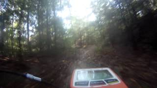
South Mills River Trail
Canton, North Carolina
10.3 miles NThis is an easy out-and-back trail that follows the South Fork Mills River with several swinging bridge crossings that leads to the site of the old Cantrell Lodge. From the trail head, the left side...
Hike, Mountain Bike 2.2 mi
Pilot Cove / Slate Rocks / 102
Canton, North Carolina
10.4 miles NFun descent with several stream crossings along the way. Nothing too steep but this trail doesn't get a lot of use so there are usually a few trees down along the way. Beautiful scenery and a...
Mountain Bike 3.7 mi

Bradley Creek Road
Horse Shoe, North Carolina
11.7 miles NThis graded FS road gradually ascends from the Bradley Creek Trail (#351) on its way to Yellow Gap Road. Enjoy the surrounding hardwood forest as you climb - the road itself is not too exciting to...
Mountain Bike 1.7 mi
Flat Laurel Creek
11.8 miles NW
Flat Laurel Creek is a 3.18 mile multi-use trail that is perfect for exploring on foot, horse and bike. This trail can be accessed from a parking lot on either end, making it easy to begin...
Hike, Horseback, Mountain Bike, Swim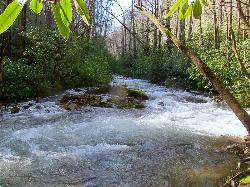
North Mills River
Mills River, North Carolina
13.0 miles NThe forest is known for its hiking and mountain biking trails, several of which are near the campground. Mills River offers excellent trout fishing, as well as tubing and swimming, which are...
Swim


