


237 Things to do near Scottsdale, Arizona
first prev 3 4 5 6 7 8 9 10 11 12 next lastShowing results within 50 miles Distance miles of Scottsdale, AZ, USA City, Zip, or Address
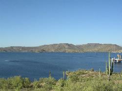
Spur Cross to Lake Pleasant
Cave Creek, Arizona
23.4 miles NStart at the Flat Tire Bike Shop and head north on Spur Cross Road. You will arrive at the Spur Cross Conservation Ranch in 3.2mi. From there enter the Maricopa Trail system and follow the signs...
Mountain Bike
Cave Creek Park
Cave Creek, Arizona
23.4 miles NMultiple singletrack loops, just explore and find what works best for you. Watch out for hikers and horses.
Mountain Bike
Clay Mine Trail
Cave Creek, Arizona
23.6 miles NClay Mine Trail is a 1.6 mile out-and-back, beginner friendly trail in Cave Creek Regional Park. This is a trail that is very close to the Visitor Center. It's not too difficult but there...
Hike 5.8 mi
Go John Trail
Cave Creek, Arizona
23.8 miles NThe Go John Trail is a 5.8 mile loop trail outside of Cave Creek, Arizona, that is moderately trafficked, used by both hikers and mountain bikers. It is an excellent opportunity to view the desert...
Hike, Horseback, Mountain Bike 8.3 mi
Estrella Mountains Competitive Track
Tolleson, Arizona
24.1 miles WThe third competitive track in the Maricopa County Regional Park system, located in Estrella Mountain Regional Park, was completed in February 2000. The track consists of two loops totaling 13 miles....
Hike, Horseback, Mountain Bike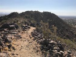
Sunrise Mountain Trail
Peoria, Arizona
24.7 miles NWThe Sunrise Mountain Trail can be found within the suburban area of Peoria, Arizona; it is made of up 3 sequential loops; each loop harder than the last. The trail is easy to find, as...
Hike, Mountain Bike
West Wing Mountain Advanced Trail
Peoria, Arizona
24.8 miles NWHike near Peoria, Arizona
Hike
Goodyear Skatepark
Goodyear, Arizona
25.0 miles WSkate Park Rules USE AT YOUR OWN RISK! This skate park is not supervised. This facility is used by both experienced and inexperienced skaters and riders. Serious injury or death may result from...
Skateboard

Lost Dutchman State Park
Apache Junction, Arizona
25.6 miles EThis park has dirt biking trails. Bikes can use the lower trails (#58) shared with hikers. Bikes are not allowed above Jacobs Crosscut Trail.The park has added a new "Mountain Bike...
Mountain Bike
Siphon Draw Trailhead to Flatiron
Apache Junction, Arizona
25.8 miles EThe Siphon Draw Trail up to Flatiron is a beautiful trail within the Lost Dutchman State Park. It is a 5.5 mile, there and back trail near Apache Junction, Arizona. It is a more advanced hike with...
Hike
San Tan
Queen Creek, Arizona
26.0 miles SETke the Goldmine trail (approximately 1.1 miles uphill on wide trail) Take left onto SanTan for approximately 1.5 miles. At this point you will reach a T. Go to right for the San Tan...
Mountain Bike
Baseline Trail
Goodyear, Arizona
26.8 miles WThe Baseline trail is a 2.6 mile loop at Estrella Mountain Regional Park. This listing is based on access from a spur trail (33.378981, -112.371072) off of the Gila trail. Access is...
Hike 13.8 mi
Butterfield to Gadsen Loop Trail
Goodyear, Arizona
26.9 miles WAs with other trails in Estrella, the trail is wide and the surface tends to be rather benign, varying from mostly smooth, to occasionally strewn with small rocks, sandy in the washes. Butterfield...
Hike, Horseback, Mountain Bike 2.9 mi
Coldwater Trail
Goodyear, Arizona
26.9 miles WThe Cold Water Trail #27 is a seldom visited, remote backcountry destination along the backdrop of the rugged Verde Rim with healthy mixed vegetation and unique geology. The trail was originally used...
Hike, Horseback, Mountain Bike
Estrella Mountain Park
Goodyear, Arizona
27.1 miles WNice mix of singletrack and doubletrack. One way loops, long loop and tech loop. A few mild climbs and some mild rock gardens, just let it ride. There is a lot of loose rocks on the...
Mountain Bike 3.6 mi
Toothaker Trail
Goodyear, Arizona
27.1 miles WToothaker is an easy roller coaster of a trail. It crosses numerous washes ranging from small to large and can be a tad loose and/or rocky in some sections. The end reward is a nice view of Rainbow...
Hike, Horseback, Mountain Bike
Dysart Trail
Goodyear, Arizona
27.1 miles W$6 entry fee per car.
Hike, Horseback, Mountain Bike
Rainbow Valley to Toothaker Loop Trail
Goodyear, Arizona
27.2 miles WEstrella Mountain Regional Park has many trails within it, a great beginner to intermediate friendly trail is the Rainbow Valley to Toothaker Loop Trail. This 6.6 mile hike is mostly flat with a few...
Hike, Horseback, Mountain Bike
Quartz Peak Trail
27.3 miles SW
Hike near
Hike 1.0 mi
Quail Trail
Goodyear, Arizona
27.3 miles WQuail Trail is the access trail from the Nature Center to the main trail system. It is a pretty steep climb, but smooth and steady. Quail Trail is a spur trail in the Estrella Mountain...
Hike, Horseback, Mountain Bike


