


Refine Search
- hike 36
- mountain bike 22
- swim 12
- disc golf 10
- horseback 6
- camp 5
- skateboard 4
- kayak 3
- hot springs 3
- canoe 3
- cave 1
- rock climb 1
- canyoneer 1
- whitewater 1
- snowshoe 1
- dive 1
60 locations
Add Location
 Full Listing
Show more
Camp, Hike, Swim
Full Listing
Show more
Camp, Hike, Swim
 Full Listing
Show more
Swim
Full Listing
Show more
Swim
 Full Listing
Show more
Camp, Hike, Hot Springs
Full Listing
Show more
Camp, Hike, Hot Springs
2.0 mi
 Full Listing
Show more
Hike, Mountain Bike
Full Listing
Show more
Hike, Mountain Bike
Loma and Canal Trails
Tempe, Arizona
0.8 miles N of Tempe, ArizonaThe Loma and Canal Trails are a pair of easy, accessible desert trails winding through Papago Park in Tempe, Arizona, at the edge of the Phoenix metro area. Open to both mountain biking and hiking, they offer a convenient, family-friendly taste of Sonoran Desert scenery amid the park's distinctive red sandstone buttes, right in the heart of the East Valley.
The Loma Trail rolls through the park on a mix of gentle uphill and downhill paths, leading to a park area with a small lake and a playground — a nice destination for a relaxed ride or walk. The Canal Trail runs along the canal at the south end of the park, offering flatter, easy going with welcome patches of shade, a rarity in the desert. Together they make an enjoyable loop for beginners, families, and anyone looking for a quick outdoor outing close to town.
Papago Park is also home to the Desert Botanical Garden, the Phoenix Zoo, and the famous Hole-in-the-Rock formation, so it's easy to pair a ride with other attractions. The trails are generally mellow and well-suited to novice mountain bikers.
As always in the desert, timing matters: hike or ride in the cooler morning or evening hours, avoid the brutal midday heat of late spring through summer, and carry plenty of water. Wear sun protection, watch for other trail users on these popular paths, and pack out your trash. For an easy, scenic desert outing in the Phoenix area, the Loma and Canal Trails are a great choice.
3.0 mi
 Full Listing
Show more
Canoe, Hike, Mountain Bike
Full Listing
Show more
Canoe, Hike, Mountain Bike
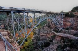
Huckaby Trail
Sedona, Arizona
0.7 miles E of Sedona, ArizonaOn the hunt for adventure? Established in 1998, Huckaby Trail is just the adventuresome route for both avid hikers and mountain bikers. It offers up forestry of Arizona Sycamores and picturesque views of the enticing Red Rocks of Sedona; along with some gnarly mountain biking challenges. You may catch an occasional breeze during the summer months, but this 3-mile trail is temperately more enjoyable during the Spring and Fall months. Although if you’re up for enduring some modest snowfall and the crisp air that comes with it a winter hike can prove to be a contrasting experience. You won’t believe you’re in the desert!
Huckaby is just a quick 5-minute drive from the city with two entrances via the north and south trailhead. At the north end, Midgley Bridge Trailhead supplies minimal parking; making this end of the trail a suitable start for early birds. The trail begins with a steep elevation drop down Oak Creek Canyon to its running waters. Feeling a swim? Bring your suit and take a dip in the creek pools. There is one large boulder passage across Oak Creek to cross before resuming on the trail. However, exercise caution, as a rise in water level can be hazardous. If waters are dangerously high, just continue down the creek and traverse through a narrower part. Be prepared for some boulder hopping either way!
For you mountain bikers, after crossing you’ll enjoy a nice half-mile cruise before pumping yourself up for an intense hike-a-bike climb. Bear in mind there are at least two of these carries throughout the trail. After conquering this feat you’re rewarded with astonishing views of Wilson Mountain and Steamboat Rock at Mitten Ridge. For you hikers, be sure to don hiking boots with a reliable grip. If you want to successfully take on this diverse terrain, then running shoes just won’t cut it!
A bench memorial sits atop the climb overlooking the surrounding landmarks - a good stopping point in your journey (if you so choose). Once you reach this point shade is less abundant the rest of the trail so be sure to have your sun protection handy. Continuing on south for about another half-mile, you will moderately descend toward Bear Wallow Wash. On the way down look out for Snoopy Rock - named after the delightful Peanuts character! A sideways glance will reveal the shape of the beagle lying on its back. Just as quickly as you began your descent another trek up-hill through switchbacks begins nearing the end of the trail. Once you reach the top the trail will level out for about 1/8 of a mile until finally reaching the finish at Schnebly Hill Trailhead. This side of the trail is known for its more ample parking space than the northern trailhead. Keep that in mind if you plan on arriving in the later part of the morning/afternoon.
Generally, this dog and kid friendly hike is a fun experience for all!
4.2 mi
 Full Listing
Show more
Hike, Mountain Bike
Full Listing
Show more
Hike, Mountain Bike
Munds Wagon Trail
Sedona, Arizona
3.1 miles E of Sedona, ArizonaMunds Wagon Trail is different from many of the other more “classic†rides around Sedona. If you come from somewhere else and are missing the feel of loose rocks & baby heads rolling around under your tires (after riding some of the other clean, well-maintained trails around Sedona), this is the trail for you. It is very fun in parts, but most mortals will do quite a lot of “hike-a-biking†on the way up. If you think you are pretty gnarly and want to test yourself, there are not many people who can clean the whole thing. The trail parallels and repeatedly crisscrosses Schnebley Hill Road, so you can always change your mind and take the road up (or back down). This is a very scenic ride, and the views just get bigger and better as you ride higher. It is about six miles and 1700 feet of elevation gain to the top. Courtesy of Singletracks.com
1.1 mi
 Full Listing
Show more
Hike
Full Listing
Show more
Hike
Piestewa Peak Summit Trail #300
Phoenix, Arizona
7.0 miles NE of Phoenix, ArizonaSome people still refer to the Peak by its original name of "Squaw Peak" before its name changed to "Piestewa Peak" in honor of Lori Piestewa who died serving her country in the Iraq conflict. The elevation of Piestewa is the second highest peak in Phoenix behind Camelback Mountain which is located nearby and features some difficult treks.Courtesy of arizona-leisure.com
The infamous Piestewa Peak Summit Trail is an out and back trail that rewards successful hikers with a three-hundred-sixty-degree view of the Phoenix metropolitan area. While short in length, a little over one mile, the trail is steep, jagged, and consists of multiple switchbacks and modified steps with integrated sections of gravel and rock. This summit trail has been a Phoenix favorite for several decades and is internationally recognized among hiking communities. Water, parking, and restrooms are available at the base of the trail.Courtesy of phoenix.gov
Although described as moderate to difficult, many kids and older adults do the Summit Trail. It's a climb all the way, and most areas have carved steps and there are two short segments with rails. It took us a little less than an hour to get to the top at a leisurely rate, frequently stopping to enjoy the scenery. If you plan to stay for the sunset, especially in winter months, it is suggested to take a flashlight as some areas become dark soon after sunset.Courtesy of hikingproject.com
The hike itself takes anywhere from 25 to 60 minutes in fair weather, depending on each hiker's capabilities (higher temperatures and sunny conditions may force the hiker to take up to twice as long). A beginning hiker should allow 60 minutes for a leisurely ascent and 40 for descent. The path is mostly well marked. There are 4 spots that are confusing and hikers who are not familiar with the path will be forced to look around for the designated route. There are a few sections that are technically difficult as they are steep and there are no guard rails.Courtesy of en.wikipedia.org
2.5 mi
 Full Listing
Show more
Hike
Full Listing
Show more
Hike
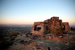
Holbert Trail to Dobbins Lookout
Phoenix, Arizona
6.7 miles S of Phoenix, ArizonaThe Holbert Trail to Dobbins Lookout is a classic Phoenix desert hike, climbing to the highest viewpoint in South Mountain Park and Preserve — one of the largest municipal parks in the country. From the stone lookout at the top, sweeping views stretch across the entire Valley of the Sun, making the climb well worth the effort for hikers wanting to take in the Sonoran Desert and the sprawling city below.
The hike runs roughly 4.5 miles round trip with about 1,000 feet of elevation gain. It's a moderate but steady climb — steep and rocky in places but not technical, on mostly gravel and sand — that takes most hikers around 2.5 to 3 hours. The trail starts near the park's main entrance and visitor center and winds up the mountain to Dobbins Lookout, where a historic stone ramada built by the Civilian Conservation Corps frames the panorama.
Heat is the real hazard here, so plan accordingly. Phoenix summers are brutal and the trail is fully exposed with little shade — hike early in the morning (or in the cooler months), carry far more water than you think you'll need, wear sun protection, and turn back if you're overheating. The park often closes trails during extreme-heat warnings.
Late fall through early spring is by far the best and safest time to hike here, with comfortable temperatures and clear desert air. Bring plenty of water and electrolytes, sturdy shoes for the rocky tread, and a hat, and pack out everything. For a rewarding city-and-desert hike with a postcard view at the top, the Holbert Trail to Dobbins Lookout is one of Phoenix's best.
0.9 mi
 Full Listing
Show more
Hike, Mountain Bike
Full Listing
Show more
Hike, Mountain Bike
Ruth Hamilton Trail
Phoenix, Arizona
7.7 miles NE of Phoenix, ArizonaThe Ruth Hamilton Trail (Trail #8B) is a short but rewarding hike in the Phoenix Mountains Preserve, in the popular Piestewa Peak and Dreamy Draw area right in the heart of the city. Named for one of the advocates who helped make the preserve possible, it's a local favorite for a quick desert workout with an outsized payoff in views.
From its trailhead the path climbs by way of rocky switchbacks to a saddle, where it meets the Quartz Ridge Trail at a well-placed observation bench — a fine spot to catch your breath and take in the sweeping panorama of the downtown Phoenix skyline and the northern Sonoran mountains. From there it rolls over another ridge and descends toward the Nature Trail on the east side of Piestewa Peak.
Though short, it's moderately rocky and gets busy, and savvy locals link it with neighboring trails (200, 202, 8A, and the 304 Nature Trail) to piece together longer loops through the preserve.
This is exposed Sonoran Desert with little shade, so summer hikers should go at dawn or dusk and carry plenty of water. Watch for other hikers and cyclists, wear real trail shoes for the rocky tread, and enjoy one of the city's handiest escapes into the hills.
3.1 mi
 Full Listing
Show more
Hike
Full Listing
Show more
Hike
Goat Hill via Telegraph Pass Trail
Phoenix, Arizona
9.1 miles S of Phoenix, ArizonaGoat Hill, reached via the Telegraph Pass Trail, is a rewarding summit hike in Phoenix's beloved South Mountain Park — one of the largest municipal parks in the country. The payoff is the view: on a clear day, the top of Goat Hill serves up a sweeping 360-degree panorama over the Valley of the Sun and the surrounding desert ranges.
The route starts out mellow — the lower Telegraph Pass Trail is smooth and almost sidewalk-like — before turning rockier as you climb toward the summit road and the final push to the top. It's a moderate outing that packs a big scenic reward into a relatively short distance, popular with locals for sunrise and sunset hikes.
This is exposed Sonoran Desert with very little shade, so the usual desert rules apply in force: go early or late in the warm months, carry plenty of water, and wear sun protection and real trail shoes for the rocky sections.
Watch for cyclists on the shared trails, and enjoy one of Phoenix's best bang-for-your-effort viewpoints — especially glorious as the city lights flicker on at dusk.
0.8 mi
 Full Listing
Show more
Hike
Full Listing
Show more
Hike
Promontory Butte
Payson, Arizona
17.1 miles NE of Payson, ArizonaPromontory Butte is arguably the finest viewpoint on Arizona's legendary Mogollon Rim — a dramatic promontory jutting out from the Rim's edge near Payson, offering a jaw-dropping panorama across endless forested country below. Perched where the high Colorado Plateau drops away in a 2,000-foot escarpment, it's a spectacular, remote spot to take in one of the Southwest's great landscapes.
From the edge of the butte, the view sweeps for miles over pine forests, canyons, and ridgelines stretching south toward Payson and beyond — especially stunning at sunset or when storms roll across the rim. Several old forest roads on the mountain double as trails out to the viewpoint, and the area connects to the historic Highline Trail that runs along the base of the Rim.
Getting there is the challenge. This is a genuinely remote destination reached by a maze of forest roads (off Forest Road 300, the Rim Road), and the final stretch — Forest Road 76B — is rough, rocky, and poorly maintained, calling for a high-clearance four-wheel-drive vehicle. Bring a good map or GPS, since signage is sparse and it's easy to get turned around.
Late spring through fall is the season (the Rim Road and high country are typically snowed in during winter). Watch the weather, as afternoon monsoon storms bring lightning to these exposed heights, and stay well back from the unfenced cliff edges. Bring plenty of water, sturdy shoes, and a full tank of gas, and pack out everything. For those willing to make the rugged drive, Promontory Butte serves up one of the most breathtaking views in all of Arizona.
Rocky Bluff
Hot Springs, North Carolina
2.3 miles SW of Hot Springs, North CarolinaRocky Bluff is a tranquil mountain getaway in the Pisgah National Forest near Hot Springs, North Carolina, where a wooded campground sits beside the lovely Spring Creek just a few miles south of town. With creekside swimming, a scenic nature trail, and excellent trout fishing — all close to the famous mountain town of Hot Springs and the Appalachian Trail — it's a peaceful basecamp for a Blue Ridge adventure.
Spring Creek is the heart of the experience: a clear North Carolina mountain trout stream that winds right through the recreation area. The Spring Creek Nature Trail (a little over a mile, easy to moderate) loops through the campground alongside the creek, with a number of access spots where you can splash into the cool water, bask on the bank, or cast for rainbow trout. Wildflowers, hemlocks, and hardwoods line the path for a lovely, shady walk.
The Rocky Bluff Campground offers a quiet, wooded place to stay, with several trailheads right on site. And the location is hard to beat: the town of Hot Springs — where the Appalachian Trail runs straight down Main Street — is just minutes away, with whitewater rafting, kayaking, and tubing on the nearby French Broad River, plus the area's namesake mineral hot springs.
Summer is prime for splashing in the creek, while spring and fall bring wildflowers and brilliant color. Bring water shoes for the rocky creek bottom, keep an eye on water levels after rain, and pack out everything you bring in. For a quiet creekside escape with a charming trail town next door, Rocky Bluff is a Blue Ridge gem.
0.8 mi
 Full Listing
Show more
Hike, Swim
Full Listing
Show more
Hike, Swim
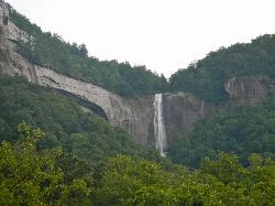
Hickory Nut Falls
Chimney Rock, North Carolina
0.1 miles W of Chimney Rock, North CarolinaHickory Nut Falls is a breathtaking 404-foot waterfall — one of the tallest in the eastern United States — cascading down the cliffs of Chimney Rock State Park in the Hickory Nut Gorge of western North Carolina. Made famous as a backdrop in the 1992 film The Last of the Mohicans (the climactic fight was filmed at the brink of the falls), it's a showstopping natural landmark and the centerpiece of one of the state's most scenic parks.
The classic way to experience it is the Hickory Nut Falls Trail, a moderate walk of roughly 1.5 miles round trip that leads through the forest to the base of the towering cascade, where you can crane your neck up at the water plunging off the cliff. The park is also home to the iconic Chimney Rock monolith and its sweeping views over Lake Lure and the gorge.
A few important planning notes. The trail and falls are inside the privately operated portion of Chimney Rock State Park, which charges an admission fee and uses timed-entry reservations, so buy tickets in advance through the park. (You can also glimpse the falls for free from U.S. Highway 64 below.) Just as important: the Hickory Nut Gorge area was hit hard by Hurricane Helene in 2024, so access, roads, hours, and reservations have been in flux during recovery — always check the park's official current status and conditions before you go.
When open, spring and fall are especially beautiful, with strong water flow and mild weather. Wear sturdy shoes for the trail, bring water, stay behind railings and away from cliff edges, and pack out what you bring. A genuine natural wonder, Hickory Nut Falls is well worth the trip when the park is open and conditions allow.
Sunburst
Canton, North Carolina
12.7 miles SW of Canton, North CarolinaSunburst is a refreshing mountain getaway along the West Fork of the Pigeon River in North Carolina's Pisgah National Forest, tucked into the high, forested country south of Canton and Waynesville along scenic NC Highway 215. Once an old logging camp, today it's a beloved spot for cold-water swimming, creekside camping, and chasing waterfalls in the Blue Ridge.
The star is the river itself. The West Fork of the Pigeon tumbles down from the high country crisp and clear, with swimming holes that stay refreshingly cold even at the height of summer — the perfect antidote to a hot day. A favorite hole sits just upstream past the bridge near the campground, where the river pools up deep enough for a bracing dip. Just up the highway, the river also forms the photogenic Sunburst Falls, a lovely cascade that spills under an old stone-arch bridge on NC 215 — an easy roadside stop worth a look.
The Sunburst Campground makes it easy to linger. This rustic Forest Service campground offers around ten primitive sites right along the river, with picnic tables, fire rings, and flush toilets (but no potable water, so bring your own for drinking and cooking). Nightly fees are modest, and the cold trout stream right outside your tent is a big part of the charm.
To get there, follow NC 215 about 16 miles south from Canton, or come north about 8.6 miles from the Blue Ridge Parkway. Summer is prime for swimming, while spring brings fuller waterfalls and fall paints the mountains in color. Wear sturdy shoes for the slick rocks, watch the water level and current after rain, keep an eye on kids in the cold water, and pack out everything you bring in. For a simple, scenic Blue Ridge river day, Sunburst is hard to beat.
Verde Hot Springs
Camp Verde, Arizona
17.4 miles SE of Camp Verde, ArizonaVerde Hot Springs is one of Arizona's most atmospheric and adventurous soaks — a cluster of natural hot pools tucked among the graffiti-covered ruins of a long-gone 1920s resort, perched on the bank of the Verde River deep in the forest west of Camp Verde. Reaching it takes some effort and a river crossing, which is exactly why this remote, free hot spring has such a devoted following.
The springs sit across the river from the Childs Dispersed Camping Area, near the site of the old Childs power plant. The historic Verde Hot Springs Resort that once stood here burned down in 1962, and today its concrete foundations — now layered in colorful murals and graffiti — cradle the main soaking pool, with several more primitive pools tucked into the cliffside above the river. Soaking in the warm mineral water with the Verde flowing past and canyon walls rising overhead is a genuinely magical experience.
Getting there is part of the adventure, and it demands respect. The drive in is a long, rough dirt road where a high-clearance (ideally four-wheel-drive) vehicle is strongly recommended. From the Childs area it's a short hike of roughly 2.5 miles round trip — but you must ford the Verde River to reach the pools. On a calm day the crossing can be ankle-deep and easy; after rain or during spring runoff it can run knee- to waist-deep with a dangerous current. Never cross when the river is high or fast, check conditions before you go, and turn back if it doesn't look safe.
The site is free and open to the public with no permit required. Come fully prepared for the remote desert backcountry: bring plenty of water, sun protection, and sturdy shoes for the ford, and pack out absolutely everything. Late fall through spring offers the most pleasant temperatures and the calmest, safest river crossings. Earn it, respect the river, and Verde Hot Springs rewards you with one of the Southwest's most unforgettable soaks.
3.9 mi
 Full Listing
Show more
Hike, Swim
Full Listing
Show more
Hike, Swim
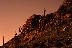
Cave Creek Swimming Hole
Cave Creek, Arizona
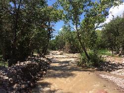
10.8 miles NE of Cave Creek, ArizonaHidden deep in the Sonoran Desert north of Phoenix, the Cave Creek Swimming Hole is a refreshing reward at the end of a true desert trek. Tucked along Cave Creek Trail #4 in the Seven Springs area of the Tonto National Forest, this clear, cool pool is a little oasis of water and shade in a landscape of cactus and canyon — and reaching it is half the adventure.
The hike in runs roughly four miles, following Cave Creek as the trail meanders through fragrant juniper, climbs onto sunny canyon slopes, and dips back toward the water. Much of the route is open desert where saguaros are your only company, but the trail repeatedly meets the creek, with shaded pockets of cottonwood and sycamore where you can cool off along the way. When the creek is flowing, it's a genuinely beautiful and peaceful walk.
At the swimming hole, the creek widens and deepens into a pool that's plenty refreshing after the miles of desert sun — the perfect place to wade in, float, and recharge before the hike back out. This is a day-use area, so plan to enjoy it and head out before evening.
A few desert-smart tips. Water levels in Cave Creek rise and fall with the seasons and can surge after a storm, so take care around the creek after rain and be alert to flash-flood risk. Carry far more water than you think you'll need for the round trip — and if you filter from the creek, treat it first, since it isn't safe to drink untreated. Sturdy shoes, sun protection, and an early start will make the desert miles much more pleasant.
The Cave Creek Swimming Hole is best from spring through early summer and again in the cooler fall, when the creek runs and the desert heat is bearable. Earn it with the hike, and you'll find one of the Phoenix area's most rewarding hidden swims.
0.2 mi
 Full Listing
Show more
Swim
Full Listing
Show more
Swim
Mormons Crossing
Cornville, Arizona
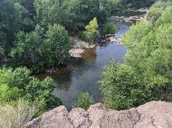
2.4 miles NE of Cornville, ArizonaMormons Crossing is one of the Verde Valley's most beloved summer hideaways — a string of clear, cool swimming holes strung along Oak Creek in Cornville, Arizona, just down the canyon from Sedona's red rocks. Locals have been cooling off here for generations, and it's easy to see why: shady cottonwoods, gentle rapids, a rope swing, and even a set of small waterfalls, all within an easy walk of the parking lot.
The creek puts on a little bit of everything. Several pools run deep enough for a real swim, short riffles and rapids give the kids something to splash through, and a well-loved rope swing hangs over one of the deeper holes. Follow the water downstream and you'll find a trio of small waterfalls — the third and largest spills into a calm, deep pool where the current finally eases off. That's the spot people stake out with pool floats, drifting in the shade while the falls do all the work. There's even a natural slick-rock slide worn smooth by centuries of flowing water.
Part of the magic is the setting. One bank is lush and green, draped in trees and leafy riparian growth, while the other rises in dramatic gray rock — a striking contrast that makes the whole canyon feel like a hidden oasis. The water itself runs clear and refreshingly cold, fed by snowmelt and springs higher up the creek, which is exactly what you want on a 100-degree Arizona afternoon.
Getting to the best pools is half the fun. From the free dirt lot beside the creek, a path follows the water before you step in and wade your way upstream — generally ankle- to knee-deep, hopping between exposed rocks. The creek bottom is rocky and the current can push in spots, so sturdy water shoes are the move here; they'll save your feet and your footing. Tuck your phone into a waterproof bag too, since a surprise dunk is all part of the adventure.
A few friendly tips to make the most of it. This is a day-use spot — there's no camping or campfires, and no restrooms or picnic tables, so pack in what you need and pack out every bit of trash to keep it beautiful for the next crew. There are no lifeguards, so pick your jumps, keep an eye on little ones, and check the water before you leap. After heavy rain or spring snowmelt the creek can run high and fast, so it's best to let it settle and visit when the flow is friendly.
The sweet spot for a visit runs from late spring into early fall, roughly May through September, when the days are hot and the swimming is just right. Pack a picnic, grab your water shoes, and come claim a shady pool — Mormons Crossing is the kind of easygoing creek day the Verde Valley does best.
2.2-2.3 mi
 Full Listing
Show more
Disc Golf, Hike, Mountain Bike
Full Listing
Show more
Disc Golf, Hike, Mountain Bike
Richmond Hill
Asheville, North Carolina
2.7 miles NW of Asheville, North CarolinaHilly, wooded course. Handmade signs and Astro Turf tees. Alt. pins on 14 holes. Long pants smart (poison ivy). Parking lot OB. Public (No Fee)Courtesy of DiscGolfUnited.com
Richmond Hill Park is Asheville's largest wooded city park. At 183 forested, hilly acres, this park connects the French Broad River and its adjoining wetland complex with the drier woods of the uplands. Its strength is its size, as this park caters to a wide variety of outdoor activities such as disc golf, mountain biking, hiking, jogging, dog walking, bird watching and just seeking serenity. The Richmond Hill Disc Golf Course is a heavily-wooded course with elevation changes in abundance. A full 18 holes are available for play. It is lengthy at 6,093 ft. and is arguably the most challenging woods course in the country. Courtesy of romanticasheville.com
Trail Map: Richmond Hill Map (2015)
1.3 mi
 Full Listing
Show more
Hike, Horseback, Mountain Bike
Full Listing
Show more
Hike, Horseback, Mountain Bike
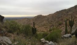
Dreamy Draw Loop Trail
Phoenix, Arizona
8.4 miles N of Phoenix, ArizonaThe Dreamy Draw Nature Trail is a short multi-access loop trail that provides a true Sonoran Desert experience. The trail crosses a number of desert washes and, at times, becomes somewhat rocky. Trail users will observe a wide variety of native Sonoran trees and other plant life and may encounter a glance at the resident wildlife. Coyotes and rabbits are commonly observed on this trail. The springtime wildflowers may offer beautiful photo opportunities. This loop trail is part offers great views of Piestewa Peak and other secluded areas near the trailhead. A restroom and drinking fountain are located near the trailhead. Courtesy of phoenix.gov
4.6 mi
 Full Listing
Show more
Hike, Horseback, Mountain Bike
Full Listing
Show more
Hike, Horseback, Mountain Bike
Perl Charles Memorial Trail (#1A)
Phoenix, Arizona
6.7 miles N of Phoenix, ArizonaThis is a technical singletrack loop with some very steep up and down sections located in the Phoenix Mountain Preserves. This trail is for advanced riders who like to bleed and leave their skin on rocks once in a while. It can be incorporated into your Trail 100 ride (see above description) or done as a 4.8 mile loop from the Dreamy Draw Recreation Center. As always with rides in the Phoenix area, the views are great of the Sonoran Desert. You will forget you are in the middle of the sprawling metropolis of Phoenix when you are out there. Courtesy of mountainbikeaz.com
Note: Hikers and Horses are also allowed on the trail.
3.9 mi
 Full Listing
Show more
Hike
Full Listing
Show more
Hike
Freedom Loop Trail (#302)
Phoenix, Arizona
6.9 miles NE of Phoenix, ArizonaFreedom Trail (#302), also known as Piestewa Circumference, is a 3.8 mile, moderate loop trail.
You can access this trail from all the inner trailheads. The easiest and least crowded being the Hopi Trailhead. That's the first left after the Ranger Station. The trail takes off in either direction behind the ramada. Heading clockwise you will encounter the summit trailhead in a quick 0.4 miles. Next you will take the summit trail for a half mile. At the 0.6 mile marker on the summit trail take a left onto the circumference route. This is the only left hand turn you take.Courtesy of hikearizona.com
A lot of the trail is very rocky, but still easily manageable. There's some steep elevation gain over two periods of the hike that give you great views, but can be an intense workout depending on your fitness level. Compared to many of the surrounding trails, this is a quieter, more isolated trail that allows you to avoid the crowds, and enjoy the views of residential Phoenix adjacent to the desert vegetation of Saguaros and cacti.
Dogs and Horses are not allowed on the Summit Trail portion of the hike.
3.4 mi
 Full Listing
Show more
Hike, Horseback, Mountain Bike
Full Listing
Show more
Hike, Horseback, Mountain Bike
Alexander Mountain Bike Park
Alexander, North Carolina
1.4 miles N of Alexander, North CarolinaNice, challenging singletrack. Not overly technical, with some nice climbs and nice flowing sections, and a nice view of the French Broad river. However, this trail does get overgrown sometimes from lack of use. Courtesy of Singletracks.com
0.8-1.1 mi
 Full Listing
Show more
Hike, Mountain Bike
Full Listing
Show more
Hike, Mountain Bike
Kiwanis Trail to Telegraph Pass Lookout
Phoenix, Arizona
7.4 miles S of Phoenix, ArizonaAn ideal hike to take children on as the distance is short and the elevation gain is not extreme. Avid hikers have opportunities to embark on longer hikes into South Mountain. ... This short hike is a gem for someone who wants to hike during the heat of the summer, but does not want to drive to higher elevation destinations. Sunrise or an hour before sunset offers shade almost the entire route. It winds through a small but pretty canyon to Telegraph Pass. The first half mile is flat only gaining 160 feet. The hike is most enjoyable after a quarter mile, signs of overuse begin to fade.Courtesy of hikearizona.com
×


