


Richmond Hill
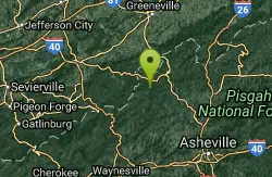
Asheville, North Carolina

| Address: | Richmond Hill Trails, Asheville, NC 28806, USA |
| GPS: |
35°37'6.9"N 82°35'21.0"W Maps | Directions |
| State: | North Carolina |
| Trail Length: | 1.20 miles |
| Trail Type: | Out & Back |
| Elevation Gain: | 49 feet |
| Disc Golf Target Type: | DISCatcher |
| Disc Golf Tee Type: | Other |
| Trails/Routes: | 0.2-2.3 mi |
Restrooms Rivers Pet Friendly
Disc Golf, Hike, and Mountain Bike
Hilly, wooded course. Handmade signs and Astro Turf tees. Alt. pins on 14 holes. Long pants smart (poison ivy). Parking lot OB. Public (No Fee)Courtesy of DiscGolfUnited.com
Richmond Hill Park is Asheville's largest wooded city park. At 183 forested, hilly acres, this park connects the French Broad River and its adjoining wetland complex with the drier woods of the uplands. Its strength is its size, as this park caters to a wide variety of outdoor activities such as disc golf, mountain biking, hiking, jogging, dog walking, bird watching and just seeking serenity. The Richmond Hill Disc Golf Course is a heavily-wooded course with elevation changes in abundance. A full 18 holes are available for play. It is lengthy at 6,093 ft. and is arguably the most challenging woods course in the country. Courtesy of romanticasheville.com
Trail Map: Richmond Hill Map (2015)
Mapped Route/Trail Distances
| Yellow Loop | 2.3 miles |
| Blue Loop | 2.2 miles |
| Red Cutoff Trail | 960 feet |
More Information
Never modify trail features. Ride trails when they're dry enough that you won't leave ruts. Speak up when you see others on the trail and always yield to hikers, horses, and others coming uphill. Always ride on the established trail.
Read MoreBe courteous, informed, and prepared. Read trailhead guidelines, stay on the trail, and don't feed the wildlife.
Read More- Plan Ahead and Prepare
- Travel & camp on durable surfaces
- Dispose of waste properly
- Leave what you find
- Minimize campfire impacts
- Respect wildlife
- Be considerate of other visitors
Directions
From Asheville, North Carolina
- Head east on S Pack Square (154 ft)
- Turn left onto N Pack Square (289 ft)
- Turn right onto Broadway St (0.3 mi)
- Slight right onto the Interstate 240 W/U.S. 70 W ramp to U.S. 74 Alternante (0.2 mi)
- Merge onto I-240 W/US-70 W (0.9 mi)
- Take exit 4A for U.S. 19 N/U.S. 23 N/U.S. 70 W/Interstate 26 toward Weaverville/Woodfin (0.2 mi)
- Continue onto I-26 W/US-19 N/US-23 N/US-70 W (256 ft)
- Take the Hill St exit (456 ft)
- Turn left onto Hill St (signs for Riverside Drive) (0.2 mi)
- Turn right onto Riverside Dr (0.9 mi)
- Turn left onto Pearson Bridge Rd (0.3 mi)
- Sharp right onto Richmond Hill Dr (0.9 mi)
- Turn rightDestination will be on the right(0.2 mi)
I-240, to Hwy. 19/23 to UNCA exit 25. Left on Broadway St. 0.2 miles to left at light, Riverside Dr., 0.4 miles to right at Pearson Bridge Rd., 0.3 miles to hard right on Richmond Hill Dr. Right at top of hill. Entrance at end, go straight thru roundabout. 20 mph through neighborhood please!.Courtesy of DiscGolfUnited.com


Trails
Distance ?
2.3 milesReal Ascent ?
475 feetReal Descent ?
475 feetGrade (-23° to 15°)
-43% to 26%Distance ?
2.2 milesReal Ascent ?
313 feetReal Descent ?
312 feetGrade (-13° to 15°)
-23% to 26%Distance ?
960 feetElevation Gain ?
48 feetReal Ascent ?
54 feetReal Descent ?
6 feetAvg Grade (3°)
5%Grade (-4° to 11°)
-7% to 19%Elevation differences are scaled for emphasis. While the numbers are accurate, the cut-away shown here is not to scale.
Other Mountain Bike Trails, Hiking Trails, and Folf Courses Nearby

UNC Asheville
Asheville, North Carolina
1.4 miles EMostly wooded with a couple holes more in the open. Good elevation! No tee signs. Bring the map to solve navigation issues. Public (No Fee)
Disc Golf
Sandhill Nature Trail Disc Golf Course
Candler, North Carolina
5.5 miles SWPlays through both open and wooded area of a large County Sports Park. Uses elevation well, offering shots of various lengths. Please use caution not to interfere with other park users. Always give...
Disc Golf 3.4 mi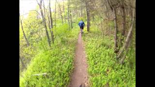
Alexander Mountain Bike Park
Alexander, North Carolina
7.3 miles NNice, challenging singletrack. Not overly technical, with some nice climbs and nice flowing sections, and a nice view of the French Broad river. However, this trail does get overgrown sometimes from...
Hike, Horseback, Mountain Bike
Enka High School Disc Golf Course
Candler, North Carolina
7.4 miles SWOnly open to public outside school hours (Weekends and Mon-Fri. 3:30 pm to dusk). Play anytime in the summer. 11 baskets with dual tees for 7 makes 18. Public (No Fee)
Disc Golf
Bent Creek
Asheville, North Carolina
8.8 miles SBent Creek is the go-to trail system for the greater Asheville area, and with the deeply-ingrained mountain bike culture in the Asheville/Brevard area, and Western North Carolina in general, Bent...
Hike, Mountain Bike
Hardtimes Connector / 661
Asheville, North Carolina
9.1 miles SThis trail connects to the main trail system and the big climbs to the top from the Hardtimes Trailhead. This section of singletrack lies in the flatter terrain but leads to the big climbs up the...
Hike, Horseback, Mountain Bike
Little Hickory Top
Asheville, North Carolina
9.1 miles SDogs: Leashed
Hike, Horseback, Mountain Bike
Trace Ridge #354
Horse Shoe, North Carolina
13.8 miles SForest Road and singletrack. This trail is exhilarating. Climb up the forest road, the single track (rolling and steep), then bust up the technical rock garden and youre home free to fast and furious...
Mountain Bike
Fletcher Creek
Horse Shoe, North Carolina
14.2 miles SFrom trailhead parking lot, ride back down gravel road. After concrete bridge, turn left on Wash Creek Road (FS5000). After proceeding up hill on FS5000 for about 2 miles, turn left onto Spencer...
Mountain Bike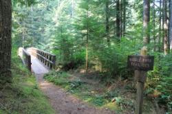
Middle Fork
Horse Shoe, North Carolina
14.2 miles SThis trail is about 8.8 miles of fire road and 2.6 miles of singletrack. There are 2 gated roads from the trailhead take the one on the right, Fletcher Creek Road (AKA The Never Ending Road). It...
Mountain Bike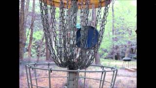
Black Mountain Disc Golf
Black Mountain, North Carolina
14.2 miles EIn a small park near a winding creek and scenic area. Relatively short but technical. Front 9 is links style - the back 9 have more length. Dual tees. Moderate poison ivy. Public (No Fee)
Disc Golf
Crookston Disc Golf Course
Fletcher, North Carolina
14.3 miles SOccupies half of a 60 acre park with some open holes and several curving into the woods along Cane Creek. Wetland in play on #4, 8, and 9. Seasonal blackberries for snacking. Public (No Fee)
Disc Golf
Mars Hill College Disc Golf Course
Mars Hill, North Carolina
14.5 miles NExcellent views, drastic elevation, tricky greens, manicured grass fairways, wooded holes and mandatories. Pack out trash. Alcohol illegal. Please be respectful. Public (No Fee)
Disc Golf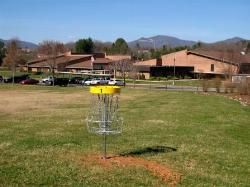
Meadowbrook Elementary Disc Golf Course
Canton, North Carolina
15.3 miles SWSurrounded by the beautiful Southern Appalachians. Long and short tees and dual baskets. A mix open and wooded holes. Primarily for students but open to the public after school (5pm) and on weekends....
Disc Golf 3.7 mi
Bradley Creek Road
Horse Shoe, North Carolina
16.2 miles SThis graded FS road gradually ascends from the Bradley Creek Trail (#351) on its way to Yellow Gap Road. Enjoy the surrounding hardwood forest as you climb - the road itself is not too exciting to...
Mountain Bike 2.2 mi
Pilot Cove / Slate Rocks / 102
Canton, North Carolina
17.7 miles SWFun descent with several stream crossings along the way. Nothing too steep but this trail doesn't get a lot of use so there are usually a few trees down along the way. Beautiful scenery and a...
Mountain Bike 4.5-5.0 mi
Kitsuma Mountain Bike Trail
Old Fort, North Carolina
17.9 miles EKitsuma Trail is an absolute classic in the Pisgah National Forest area, so classic in fact that Litespeed Bicycles named one of their old Hardtails after the trail. After a short road...
Mountain Bike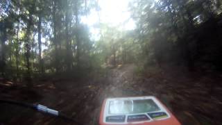
South Mills River Trail
Canton, North Carolina
18.5 miles SWThis is an easy out-and-back trail that follows the South Fork Mills River with several swinging bridge crossings that leads to the site of the old Cantrell Lodge. From the trail head, the left side...
Hike, Mountain Bike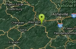
Bethel Elementary School
Waynesville, North Carolina
19.2 miles SWBeautiful campus surrounded by the Southern Appalachians. Greatnview of famous Cold Mountain. Best to play after school and on weekends. Blackberry bushes rule the OB. Public (No Fee)
Disc Golf
Pink Beds
Pisgah Forest, North Carolina
19.7 miles SWGreat warm up/cool down trails or beginner trails for Pisgah, as they are mostly flat. The bikeable portion of this trail will dump you out on a gravel road near the South Mills River trail after...
Mountain BikeNearby Campsites
Rocky Bluff
Hot Springs, North Carolina
22.2 miles NWPlay in water in creek, shallow at times.
Camp, Hike, Swim
Davidson River Campground
Pisgah Forest, North Carolina
24.5 miles SDavidson River Recreation Area offers camping and outdoor activities for the whole family. The campground boasts several loops of shaded campsites, as well as access to hiking trails, fishing spots,...
Camp, Hike, Swim
Mount Mitchell Area
Trinity, North Carolina
25.1 miles NENice family swimming place right by N. F. campgrounds in the South Toe River (cold) in the Pisgah N. F... Fees: Yes This site is closed seasonally.
Camp, Swim
Old Forge Campground
Bethany, Tennessee
33.2 miles NOld Forge Campground and Recreation Area is a small campsite perfect for campers looking for a primitive experience. Old Forge is located on the beautiful Jennings Creek in the Cherokee National...
Camp, Hike, Swim
Horse Creek Campground
Chuckey, Tennessee
34.0 miles NHorse Creek Campground is a popular day use and camping location in the Horse Creek Recreation Area. This beautiful spot in the Cherokee National Forest is a great location to connect with nature...
Camp, Swim
Cosby Campground
Cosby, Tennessee
36.0 miles WCamp and Swim near Cosby, Tennessee
Camp, Swim
Mt. LeConte Lodge
Sylva, North Carolina
41.0 miles SWHigh atop Mt. LeConte in the Great Smoky Mountains National Park, LeConte Lodge® is the highest guest lodge in the eastern United States. It is situated on an open glade just below the summit of...
Camp, Hike, Horseback, Rock Climb


