


31 locations
Add Location
 Full Listing
Show more
Hike, Swim
Added on 26 Jul 2018
Full Listing
Show more
Hike, Swim
Added on 26 Jul 2018
 Full Listing
Show more
Backpack, Hike
Added on 7 Jul 2018
Full Listing
Show more
Backpack, Hike
Added on 7 Jul 2018
 Full Listing
Show more
Hike
Added on 5 Jun 2018
Full Listing
Show more
Hike
Added on 5 Jun 2018
0.8-4.1 mi
 Full Listing
Show more
Hike, Swim
Added on 28 Jul 2018
Full Listing
Show more
Hike, Swim
Added on 28 Jul 2018
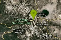
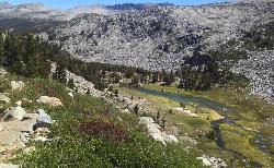
Dog Lake and Lembert Dome
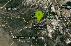
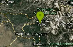
Yosemite Valley, CA
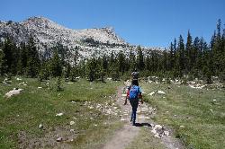
17.2 miles NE of Yosemite Valley, CAThe hike to Dog Lake is often paired with the hike to Lembert Dome, because the two are so close in proximity. Each hike by itself is 2.8 miles round trip, but Lembert Dome has an elevation gain of about 800 feet as opposed to Dog Lake's 600 feet. To do both of them together, it's about 4 miles round trip.
Dog Lake and Lembert Dome are in the Tuolumne Meadows area of Yosemite's backcountry, meaning there are tons of surrounding wildflowers and beautiful scenery along the way. Because they are both such short lakes, even when done together, it usually only takes about 1.5-3 hours to complete. It's a great last minute option if you find yourself having some extra time during your trip. The lake is surrounded by evergreen trees, granite mountains, and wildflower meadows.
It's a fairly steep trail, and climbs pretty consistently until it reaches a junction. Turn left at the junction to reach Lembert Dome, where you'll receive an awesome view of Tuolumne Meadows. To reach Dog Lake, continue straight at the junction.
The trail is open as long as Tioga Road is open, which is typically June to November. Remember to stay off the domes during thunderstorms.
6.1 mi
 Full Listing
Show more
Backpack, Camp, Hike
Added on 28 Jul 2018
Full Listing
Show more
Backpack, Camp, Hike
Added on 28 Jul 2018
Glen Aulin
Wawona, California
28.8 miles NE of Wawona, CaliforniaThis is an 11 mile hike along the Tuolumne River to Glen Aulin. There is a view to take in at every turn on this hike, whether it's the Tuolumne River, Tuolumne Fall, Soda Springs, Parsons Memorial Lodge, or White Cascade. There are also several wildflower meadows along the way, especially towards the beginning of the hike.
The total elevation gain is 800 feet, which is pretty low considering the distance, which is upwards of 11 miles. If you can last the 6-8 miles it will take to reach Glen Aulin, then you'll be able to soak in some of the best parts of Yosemite's backcountry without doing too much climbing.
Once you reach Glen Aulin, there are several places to camp, including the Backpackers Campground, which provides tents, or the High Sierra Camp. If you plan on staying in Glen Aulin for a few days, you might consider hiking to to Waterwheel Falls and the Grand Canyon of the Tuolumne, two popular attractions in the Tuolumne Meadows area.
The hike is available as long as Tioga Road is open, which is typically June to November, but it would be more enjoyable the earlier in the season you go due to the snow melting and feeding into the waterfalls.
4.0 mi
 Full Listing
Show more
Hike, Swim
Added on 27 Jul 2018
Full Listing
Show more
Hike, Swim
Added on 27 Jul 2018
Mono Pass
Yosemite Valley, CA
20.7 miles NE of Yosemite Valley, CAAt an elevation of 10,600 feet, the hike through Mono Pass is an 8 mile journey that takes you across the High Sierras, through several meadows, and stops at a few different lakes along the way.
The first part of the trail guides hikers through the streams and meadows of the High Sierras. Once it hits the Spillway Lake Junction, the trail starts to get a little bit more strenuous. The scenery begins to change as well. The closer the trail climbs towards Bloody Canyon, the more rocky and barren the landscape becomes. The latter half of the hike offers views of the majority of Mono Valley, including Mono Lake and, if you're up for a little more traveling, Upper Sardine Lake as well.
While the pass is already at a significantly high elevation, there is still a 1000 foot elevation gain on the hike, so be prepared to notice a loss of oxygen and bring any headache remedies you may need, especially if you're coming into Yosemite at sea level.
Mono Pass is open as long as Tioga Road is open, which is typically June to November, but because of the elevation, it's not uncommon for snow to obstruct several of the viewpoints if you are there too early in the season.
0.9-3.2 mi
 Full Listing
Show more
Hike, Swim
Added on 27 Jul 2018
Full Listing
Show more
Hike, Swim
Added on 27 Jul 2018
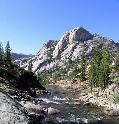
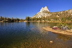
Cathedral Lakes
Wawona, California
24.8 miles NE of Wawona, CaliforniaOne of the busiest trails in the Tuloumne Meadows area, the hike to Cathedral Lakes is a gorgeous 7 mile walk to the perfect place to rest and recuperate.
While there are several High Sierra lakes, the Cathedral lakes are arguably the most popular because this hike was part of the John Muir trail. At an elevation of roughly 10,000 feet, Cathedral Peak sits on the east and both Echo and Tressider Peaks sit in the south, while Lower Cathedral Lake rests in the middle.
There is a wide, easily accessible rock shelf that hangs over Lower Cathedral Lake. Many hikers enjoy soaking in the view, which, from the rock shelf, includes Tenaya Lake, while recovering from the 1000 foot climb up to the lake.
There is a fork in the trail, and you will have to choose between Upper and Lower Cathedral Lake. Upper Cathedral Lake is part of the John Muir Trail and will take you to the Sunrise High Sierra Camp, and Lower Cathedral Lake is a little bit more popular and a little bit bigger as well.
The trail to Cathedral Lakes is open as long as Tioga Road is open, which is June through November. Expect marshy conditions in the early season.
1.8 mi
 Full Listing
Show more
Hike, Swim
Added on 27 Jul 2018
Full Listing
Show more
Hike, Swim
Added on 27 Jul 2018
Gaylor Lakes
Yosemite Valley, CA
21.2 miles NE of Yosemite Valley, CAGaylor Lakes is one of Yosemite's most underrated hikes. It's a 2 mile trail with views the entire way. At various points along the trail, you can see Dana Meadows and the mountains beyond it, like Gibbs and Mammoth. When you reach the top of the pass, you can see the mountains on the east of Yosemite as well as the Gaylor Lakes valley, which contains five separate lakes. The valley also offers views of the Tuolumne Meadows and the surrounding mountains. This hike has an amazing pay off for the amount of effort required.
The total elevation gain is about 500 feet, so if you're less experienced, you'll definitely start to feel it a few miles in to get to the valley, but once you reach the valley itself, it's mostly flat with a few subtle inclines. Because there is so much to see, this is a hike that lends itself to a little bit of improvisation. Many visitors like to wander around through the valley and the meadows and soak it in along the way. The trail will take you to the Middle Gaylor Lake, but the others are all nearby and most are easily accessible from the valley.
Elizabeth Lake
Wawona, California
26.4 miles NE of Wawona, CaliforniaElizabeth Lake is a gorgeous lake tucked underneath the High Sierras in Yosemite. It's about a 4.8 mile hike to reach it, with an elevation gain of 1000 feet. Even though it's not super long, the trail climbs steadily up, especially for the first mile, so the view does make you work for it a little.
The trailhead is right outside the Tuloumne Meadows Campground and takes the B loop of the campground to the lake.
Resting between Cockscomb, Unicorn Peak, and Johnson's Peak, Elizabeth Lake is within the Tuloumne Meadows and backcountry portion of Yosemite Valley. This means it's not a super trafficked or crowded hike, and it gives views of Yosemite that are less common, but still just as beautiful. Many people decide to start working through the backcountry once they've done all of the main Yosemite activities. If you are planning on taking a couple strolls through Tuloumne Meadows, be sure to get a permit to allow you and your party access to the hikes you're wishing to take.
If you reach the lake and are still hoping for more of a challenge, you might choose to hike up to Unicorn Peak for an amazing vantage point of Cockscomb and the rest of the backcountry.
3.6 mi
 Full Listing
Show more
Hike
Added on 26 Jul 2018
Full Listing
Show more
Hike
Added on 26 Jul 2018
Lyell Canyon
Wawona, California
29.8 miles NE of Wawona, CaliforniaLyell Canyon is a breezy, 8 mile hike through the Tuloumne Meadows of Yosemite. While it is a little bit of a longer hike, the total elevation gain is about 200 feet, making it pretty flat and straightforward.
Starting at Dog Lake, the hike takes you through the Tuloumne forest, as well as the Lyell Fork of the Tuolumne River. There are several creek crossings, and the canyon itself offers views of the Kuna Creek cascades.
Lyell Canyon was named after Charles Lyell, a famous English geologist. The hike is another one of Yosemite's lesser known gems in the backcountry, away from the more popular and crowded areas of the surrounding Yosemite Valley. Travel through the forest to get some peace and quiet and see the parts of Yosemite people don't talk about.
If you're planning on taking this hike, be sure to pick up a permit for the Tuloumne Meadows. This is done to regulate the amount of people in the backcountry.
Because there are so many berries and streams along this hike, it wouldn't be too uncommon to happen across a bear during your journey. Be sure to exercise caution when planning this trip and do not hike alone.
5.5 mi
 Full Listing
Show more
Hike, Swim
Added on 26 Jul 2018
Full Listing
Show more
Hike, Swim
Added on 26 Jul 2018
Ostrander Lake
Wawona, California
8.4 miles NE of Wawona, CaliforniaOstrander Lake is a long, 11.4 mile hike just behind Sentinel Dome. Unlike most of Yosemite's summer hikes, the trail to Ostrander Lake is open during the winter for people to ski through. Ostrander Lodge offers cross country skiers a place to sleep during their travels.
In the summer, the Ostrander Lake trail is littered with wildflowers, streams, and meadows. The lake itself is surrounded by large granite mountains, making it the perfect place for a semi-secluded swim.
The total elevation gain is about 1600 feet. This hike is no joke, but it's a beautiful one. The first part of it is a subtle ascent through the forests and wildflower meadows. It gets more difficult during the latter portion, where travelers can see the damage done by an 1987 lodgepole pine fire in the area. Reaching the lake also includes views of Mount Starr Dome, the Clark Range, and the Illiouette Creek Basin. The hike reaches its peak at an elevation of 8,720 feet and then drops down 200 feet to the lake.
Ostrander Lake is about six miles from Yosemite Valley, making it a great option for people looking to get away from the main traffic and head more towards Yosemite's backcountry. As long as Glacier Point Road is open, the trail to Ostrander Lake is open.
1.7 mi
 Full Listing
Show more
Hike
Added on 19 Jul 2018
Full Listing
Show more
Hike
Added on 19 Jul 2018
Mono Meadow
Yosemite West, Yosemite National Park
5.1 miles S of Yosemite West, Yosemite National ParkThe hike through Mono Meadow is the best way to get a view of Mt. Starr King, Clarke Range, and Half Dome all at once. It's about a three mile round trip hike towards Yosemite backcountry. It tends to stay really wet throughout the year, so it's typical for visitors to see a lot of mud and log crossings over creeks.
Three miles through Mono Meadow leads hikers to several options of things to do next, whether it's Half Dome, the High Sierras, or the more secluded Illiouette Creek. The Mono Meadow area is still recovering from some wild fires that have occurred, making a lot of burned trees and snags in the path pretty typical for those who visit to encounter.
Most people hiking through Mono Meadow are on their way to something else; few are rarely there just for the meadow itself. The trail is pretty lightly trafficked, making it a good place to look for wildlife.
It's a short, easy hike that leads to awesome views of the park. The elevation gain is 300 feet, making it more of a walk than a hike. The meadow is only open June to November, and the it's usually greener earlier in the season, so if you're interested in seeing the wildflowers at their peak, be sure to come early.
1.2 mi
 Full Listing
Show more
Hike
Added on 17 Jul 2018
Full Listing
Show more
Hike
Added on 17 Jul 2018
Taft Point
Yosemite Valley, Yosemite National Park
2.3 miles S of Yosemite Valley, Yosemite National ParkThe hike to Taft Point is often paired with the hike to Sentinel Dome. There is a 5 mile loop that connects the two and offers breathtaking views of the valley along the south rim.
The trailhead takes you first to Sentinel Dome. You will reach a spur trail that will take you straight to the Sentinel Dome's summit after just under a mile of hiking. After enjoying the summit, go back to the spur trail and take the opposite direction to go to Taft Point. From the junction to Taft Point is about 1.5 miles, all while enjoying looking over the valley at an elevation of about 3,000 feet.
This hike offers particularly good views of El Capitan. It's a similar experience to hiking to Glacier Point. The hike up to Taft Point is a typical Yosemite walk through the woods. It's a relatively easy hike, with the elevation gain being around 200 feet.
Another unusual feature about Sentinel Dome and Taft Point are the fissures that line the outside of the cliff. These are large gashes on the edge of the cliff that go straight down and create some amazing scenery.
Because there are no guard rails, be sure to use caution when testing your fear of heights.
0.5 mi
 Full Listing
Show more
Hike
Added on 17 Jul 2018
Full Listing
Show more
Hike
Added on 17 Jul 2018
McGurk Meadow
Yosemite National Park
14.3 miles S of Yosemite National ParkMcGurk Meadow is a short, 0.8 mile hike through one of Yosemite's wildflower meadows. The trail is fairly flat, about 100 feet of elevation gain, and it doesn't require too much effort, allowing it to be more of a walk in the park than a hike.
The meadow is a secluded, peaceful place to travel to if you have extra time during your Yosemite trip. Very few people know about McGurk Meadow, despite its charm. It takes about 30-60 minutes to complete, and there is a full brook that runs through it. Many people pass through McGurk Meadow to get to Dewey Point, as both locations use the same trailhead.
The trail takes you through a wooded forest and a small section of Peregoy Meadow. At the edge of the meadow lies an old cabin built by John McGurk in the late 1800s.
The turn off is off Glacier Point Road, which is open June through October, but the best time to see the meadow is in the summer months. Because there is no parking lot at the trailhead, the trip to McGurk Meadow is not very well traveled. Both the turn off and the sign for the trailhead are well marked and easy to find.
5.7 mi
 Full Listing
Show more
Backpack, Camp, Hike
Added on 14 Jul 2018
Full Listing
Show more
Backpack, Camp, Hike
Added on 14 Jul 2018
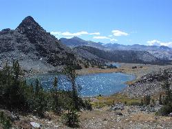
Ten Lakes
Tuolumne Meadows, Yosemite National Park
8.8 miles W of Tuolumne Meadows, Yosemite National ParkA 6.4 mile hike will lead you to three of the Ten Lakes at Ten Lakes Basin. There are three possible trails to take to see this phenomenon. The shortest begins at Yosemite Creek. The other two are much longer. One begins at May Lake and takes about 13 miles and the other begins at Murphy Creek and takes about 14 miles.
Once you reach the end of the trail, there are several other short trails that will take you to the rest of the lakes. However, despite the name, there are only seven lakes in total. There are more things to see than just lakes, though. The basin is surrounded by wildflower meadows, woodland, as well as the Grand Canyon of the Tuolumne River. The
Each of the hikes take you through several wooded forests, as well as the Halfmoon Meadow. The trails to the lakes are a steady climb up to the basin. The total elevation gain is about 2200 feet, and the last stretch of the 6.4 mile hike is slightly more strenuous.
Many visitors enjoy camping up at the Ten Lakes Basin or at the Grant Lakes to give themselves the chance to explore each of the lakes.
4.1 mi
 Full Listing
Show more
Backpack, Hike
Added on 14 Jul 2018
Full Listing
Show more
Backpack, Hike
Added on 14 Jul 2018
North Dome
Yosemite Valley, Yosemite National Park
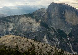
2.0 miles NE of Yosemite Valley, Yosemite National ParkNorth Dome is a strenuous 10.4 mile hike that gives visitors a close up view straight at Half Dome from across the valley. It also has a unique view of Clouds Rest peak.
Because the hike itself is rather uneventful, there aren't too many people found on this trail. The majority of the uphill climb is walking through Yosemite forest. Hikers will have to cross Porcupine Creek, as well as a small, grassy meadow. Once the trail gets closer to North Dome, it starts to get interesting. In order to reach the summit, the trail descends down a rock trail to the base of North Dome, and then requires hikers to work their way back up to the summit.
North Dome is a long, strenuous hike, but the view at the destination is spectacular. North Dome offers the best view of Yosemite's most famous attraction, as well as a view of the valley from an elevation of 7,450 feet. There is also a .6 mile detour on the return trip for those wanting to see the Indian Rock Arch, a 15 foot natural granite arch.
The hike to North Dome is only available when Tioga Road is open, usually in the summer and fall.
1.3-1.6 mi
 Full Listing
Show more
Hike, Swim
Added on 12 Jul 2018
Full Listing
Show more
Hike, Swim
Added on 12 Jul 2018
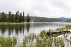
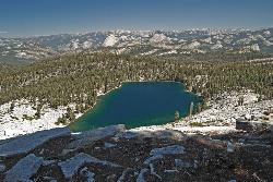
May Lake
Yosemite Valley, Yosemite National Park
8.9 miles NE of Yosemite Valley, Yosemite National ParkMay lake is a relatively small lake that rests at the base of Mt. Hoffman in Yosemite National Park. One of the park's most scenic lakes, May lake not only gets up close and personal with beautiful granite cliffs, but it sits at an elevation of 9,270 feet and offers views of both Clouds Rest and Teyana Lake.
The hike to May Lake is only 2.5 miles round trip, but it has an elevation gain of 500 feet, so it climbs pretty steadily upward. Many visitors choose to hike both May Lake and Mt. Hoffmann, which adds 3.5 miles and about an extra 1500 feet of elevation to the hike.
Mt. Hoffmann sits at an elevation of 10, 845 feet and offers views of Clouds Rest, Half Dome, the northern Yosemite wilderness, and views of May Lake from above as well.
Charles Hoffmann allegedly named the mountain after himself and the lake after Lucy Mayotta Brown back in 1867. Three years later, the two were married.
Because the trailhead starts on Tioga Road, this hike is usually closed in the winter, so be sure to check road conditions before you embark. Also remember to pace yourself as you gain elevation and the oxygen gets thinner.
0.7 mi
 Full Listing
Show more
Hike, Swim
Added on 12 Jul 2018
Full Listing
Show more
Hike, Swim
Added on 12 Jul 2018
Lukens Lake
Tuolumne Meadows, Yosemite National Park
13.9 miles W of Tuolumne Meadows, Yosemite National ParkLukens Lake is a small lake in the White Wolf area of Yosemite National Park. The hike is a short, 1.6 mile walk through a forest to the secluded lake surrounded by trees and a small wildflower meadow. This lake is famous for the luminescent shooting stars that are easily spotted while swimming here, so although it's not the most popular lake in the valley, it's not uncommon to have company while you're there.
There are two separate trails that will take you to Lukens Lake, one is 1.6 miles and starts from Tioga Road, and the other is 4.6 miles and starts from the White Wolf Lodge. Both trails have a low elevation gain, about 200-300 feet, and lead you through some pretty thick woods until you reach the lake. The longer trail crosses the Middle Fork of the Tuolumne River has a few more wildflowers and streams, but mostly it's just a longer walk in the forest.
The best time to visit is in July, when the wildflower meadows are at their peak. Tread carefully, though, because the trail is typically wet and muddy until August. It's also important to stay on the marked path so as not to damage the meadows.
Harden Lake
Big Oak Flat, Yosemite National Park
13.2 miles E of Big Oak Flat, Yosemite National ParkThe hike to Harden Lake at Yosemite is essentially a long walk. Much of the trail is walking down Tioga Road, an old gravel street that has been part of Yosemite since its foundation. The trail is wide, and there isn't much of an elevation gain. The only reason it isn't one of the easiest hikes in the valley is because of its length. Harden Lake is about 5.8 miles from the trailhead, which is longer than most beginners are comfortable with.
About two miles into the hike, you'll reach the Middle Fork of the Tuolumne River. Follow the signs that lead to the lake. Along the trail, there are small granite domes, a red fir forest, and lodgepole pines.
The lake itself, although not one of the most popular in the park, offers a quiet and serene place to finish the hike and take in the scenery. There are tons of rocks and trees surrounding the lake, as well as a meadow of wildflowers.
For those who want to continue hiking, there is a trail just beyond the lake that will lead to the Grand Canyon of the Tuolumne River. This makes the hike a total of 8.3 miles roundtrip, with an elevation gain of 1000 ft on the return trip.
2.1 mi
 Full Listing
Show more
Backpack, Hike
Added on 12 Jun 2018
Full Listing
Show more
Backpack, Hike
Added on 12 Jun 2018
Snow Creek Falls
Yosemite Valley, Yosemite National Park
3.5 miles NE of Yosemite Valley, Yosemite National ParkSnow Creek is one of the more difficult waterfalls to find in the valley, but in the spring and summer months, the elusive waterfall can be seen from the Mirror Lake Trail, a 5 mile loop around Mirror Lake.
The first mile of the Mirror Lake Loop is a flat, straightforward path to Mirror Lake, one of Yosemite's most popular swimming holes. Continuing around the lake, the trail eventually meets the Snow Creek Trail, a separate, strenuous 9 mile hike. It's at this junction that Snow Creek Falls can be spotted.
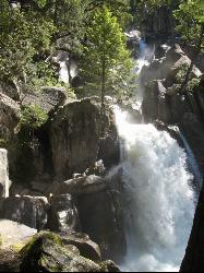
Snow Creek Falls is 2,140 feet of cascades enveloped in Tenaya Canyon. The entire fall is made up of seven separate drops, the longest being 500 ft. Because of the deep recesses of the rocks it flows over, it is almost tucked away inside the canyon. But if you know where to look, you can find it.
Mirror Lake Loop is the least strenuous way to access the falls, and you can stop for a swim on your way over. However, if you're looking for something more challenging, Snow Creek Falls can also be seen from the "Diving Board," an obscure rock protrusion at the Half Dome summit.
2.5 mi
 Full Listing
Show more
Hike
Added on 5 Jun 2018
Full Listing
Show more
Hike
Added on 5 Jun 2018
Chilnualna Falls
Wowana, Yosemite National Park
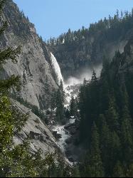
1.0 miles NE of Wowana, Yosemite National ParkLocated near the southern entrance of the valley, Chilnualna Falls is one of the lesser known waterfalls in Yosemite. The hike is about 8 miles round trip and takes you to the upper part of the falls which runs into a few small nature pools. The lower 240 ft are difficult to see from the top, but can be seen at various points throughout the hike. The best view of the entirety of the falls is when you're about a quarter of a mile away, but a switchback leads you back into the forest and away from the water.
Although it's a steady climb up, the hike also takes you through several forests and you can stop at Chilnualna Creek on your way up. Because the trail goes in and out of shady wooded areas, it's not too difficult to keep cool if you go early enough. In the spring, there will often be mist rising from the falls and the creek that help cool you down as well.
Horses are allowed on this trail. There is a fork in the trail towards the beginning of the hike. The left allows horses, and the right is for hikers only. Watch out for rattlesnakes and the ocassional poison oak.
0.4-2.1 mi
 Full Listing
Show more
Hike
Added on 5 Jun 2018
Full Listing
Show more
Hike
Added on 5 Jun 2018
Illilouette Falls
Yosemite West, Yosemite National Park
2.8 miles SE of Yosemite West, Yosemite National ParkIllilouette Falls Trail is a 4 mile hike down to Illilouette Creek, where there is a footbridge, a great view of Illilouette Falls, and several benches for onlookers to stop, rest, and enjoy a snack. The hike begins at Glacier Point, but it actually starts going downhill, making the return trip the more difficult one of the two.
To get an even better view of the falls, some choose to take the Panorama Trail once reaching the creek. This trail is an extra mile long and leads to a slightly dangerous lookout over Illilouette Falls. The Panorama Trail is peaceful, less traveled, and it's not uncommon for hikers to come across deer on their way to the Falls. The first half of the Panorama Trail also provides views of Half Dome and Nevada and Vernal Falls. After reaching the lookout, you can turn around and make your way back to the car, or you can continue on for another three miles to reach the mist trail.
Like most waterfalls in Yosemite Valley, Illilouette Falls flows all year but is at its peak in the spring and summer months. In the fall and winter months, the falls tend to dry up.
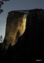
Horsetail Falls
Yosemite Valley, Yosemite National Park
2.2 miles SW of Yosemite Valley, Yosemite National ParkHorsetail Falls is located near El Capitan Valley in Yosemite. Around mid to late February, the fall gains popularity due to the way the orange glow of the sunset radiates off of it. In order to witness this "firefall" phenomenon, there has to be enough snowmelt for the water to flow, and the sky has to be clear. Even a small amount of clouds could reduce the effect or eliminate it altogether.
While it is possible to view from the car, permits are now required to park at the viewing spot. You can reserve a parking permit online, but there are only 250 available. If the permits run out before you can grab one, or you'd rather walk, you can take the short walk from Yosemite Valley Lodge.
The hike is 1.5 miles from the lodge to the viewing spot and runs along Northside Drive. An extra .4 miles will take you to the El Capitan Picnic Area, where picnic tables are available, so you can watch the "firefall" and enjoy a meal. Because the phenomenon happens at night, be sure to prepare accordingly. You should take a flashlight, jacket, and gloves. The average low temperature in February is 30 degrees Fahrenheit.
×


