


Refine Search
- hike 74
- swim 56
- kayak 16
- canoe 14
- mountain bike 13
- camp 11
- horseback 3
- backpack 3
- skateboard 1
- disc golf 1
- whitewater 1
- snowshoe 1
121 locations
Add Location
 Full Listing
Show more
Swim
Added on 31 Jul 2023
Full Listing
Show more
Swim
Added on 31 Jul 2023
 Full Listing
Show more
Swim
Added on 31 Jul 2023
Full Listing
Show more
Swim
Added on 31 Jul 2023
 Full Listing
Show more
Canoe, Kayak, Swim
Added on 30 Jun 2023
Full Listing
Show more
Canoe, Kayak, Swim
Added on 30 Jun 2023
 Full Listing
Show more
Swim
Added on 30 Jun 2023
Full Listing
Show more
Swim
Added on 30 Jun 2023
 Full Listing
Show more
Canoe, Kayak, Swim
Added on 30 Jun 2023
Full Listing
Show more
Canoe, Kayak, Swim
Added on 30 Jun 2023
 Full Listing
Show more
Canoe, Hike, Kayak, Swim
Added on 1 Jun 2023
Full Listing
Show more
Canoe, Hike, Kayak, Swim
Added on 1 Jun 2023
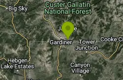
Coyote Creek Trail
Gardiner, Montana
3.9 miles E of Gardiner, Montana near Gardiner, Montana
Full Listing
Show more
Added on 31 May 2024
7.3 mi
 Full Listing
Show more
Hike
Added on 25 Jan 2024
Full Listing
Show more
Hike
Added on 25 Jan 2024
Agate Creek Trail
Tower Junction, Wyoming
0.8 miles E of Tower Junction, WyomingAgate Creek Trail is a moderately difficult trail through some of Yellowstone's most beautiful and isolated landscapes. This 7.3 mile hike starts at the Yellowstone River Picnic Area. Parking is available at the picnic area where the trailhead can be found.
The trail follows along Yellowstone River giving hikers stunning views of the Bump-Sullivan Resivoir and the Narrows along the way. These stunning overlooks off of colorful cliffs to the rushing river are a sight to behold and well worth th hiker.
Hikers will follow Specimen Ridge Trail until it splits off into Agate Creek Trail. At the end of the trail hikers will find Agate Creek Campground. This is a primitive campground. Those hoping to camp overnight will need to haul everything in and out with them.
Hikers and campers should be aware of wildlife, and keep a safe distance. Hikers should carry bear spray and keep it accessible. Campers should follow all bear safety guidelines for food preparation and storage.
4.0 mi
 Full Listing
Show more
Hike
Added on 30 Dec 2023
Full Listing
Show more
Hike
Added on 30 Dec 2023
Specimen Ridge Day Hike and Fossil Forrest Trail
Buffalo Ford, Wyoming
2.6 miles E of Buffalo Ford, WyomingSpecimen Ridge Day Hike is a strenuous almost 4 mile trail to Specimen Ridge. This trail is rugged with a high elevation, and is not recommended for hikers with respiratory or heart problems.
The hike begins at a pullout on North East Entrance Road. From the pullout hikers will take a old service road through a dryer, flatter section of the valley, before reaching the forested area and heading up to Specimen Ridge. The path is not well marked, but it is the most obvious path and fairly easy to follow, and the view from the ridge is easily worth the strenuous hike.
Hikers in this area can also enjoy hiking Fossil Forrest Trail. Fossil Forrest Trail is a separate trail on Specimen Ridge that takes hikers to an outcropping with fossilized trees. From Specimen Ridge hikers can look down and locate the outcropping in the 2 o'clock position.
Hikers should be careful not to leave trail for crossing wildlife trails, and should descend the way they came. Hikers should keep a safe distance from all wildlife and keep bear spray with them and readily accessible.
14.8 mi
 Full Listing
Show more
Backpack, Camp, Hike
Added on 30 Nov 2023
Full Listing
Show more
Backpack, Camp, Hike
Added on 30 Nov 2023
Biscuit Basin to Fairy Falls and Firehole Meadows
Old Faithful, Yellowstone National Park
5.2 miles W of Old Faithful, Yellowstone National ParkFreight Road trail is a almost 15 mile hike that leaves from Biscuit Basin or Fountain Flats Drive. This hike is a beautiful remote hike that passes several unique landmarks, breaking up this hike into several breathtaking sections.
Starting from Biscuit Basin the hike begins with a stunning view of several turquoise pools and bubbling geysers. The path here is an easy boardwalk starting the hike off in a more popular section of the park. At the end of Biscuit Basin hikers will find a trail marked Mystic Falls. Hikers will begin a moderately easy section of the hike passed the colorful and forested Mystic Falls, a 70 foot roaring waterfall. After passing Mystic Falls hikers will come to Fairy Creek Trail and take that trail until they reach Firehole Meadows.
Firehole Meadows has a sweeping view of the flat meadows with mountains rising in the distance. Firehole Meadows is a great place to do some back country camping and enjoy the quiet of this secluded area of the park.
Continuing on Fairy Creek Trail hikers will pass Imperial Geyser and be able to enjoy the stunning colors of the geyser activity in this area, and camp overnight at the Imperial Meadows of Goose Lake Campgrounds. Gooselake is a collection of three small lakes with stunning blue water and rust red shores. For hikers and campers looking for an extra excursion, there is a short jut off the trail in this area to the towering, misty Fairy Falls.
Once past the Imperial Geyser area Fairy Creek Trail meets up with Freight Road. Hikers can start and end this hike at either end, with parking available in both places. Hikers will need a camping permit to stay overnight at any of the camping locations. Campers should hike in groups of more than tree, and keep a lookout for and a safe distance from all wildlife. Hikers should also keep readily accessible bear spray on them at all times.
10.1 mi
 Full Listing
Show more
Backpack, Hike
Added on 30 Nov 2023
Full Listing
Show more
Backpack, Hike
Added on 30 Nov 2023
Sky Rim Trail to Sheep Mountain
Big Sky, Montana
18.3 miles SE of Big Sky, MontanaSky Rim Trail to Sheep Mountain is a challenging hike with stunning and famous views. This 10 mile out-and-back trail starts at Dailey Creek Trailhead (WK1). The trail follows Dailey Creek over gentle slopes and through beautiful fields until it connects with Sky Rim Trail. Sky Rim Trail lead hikers up mountain ridges coming to some of the highest peaks in Yellowstone, including Big Horn Peak and Sheep Mountain Peak. These mountains are both named for the big horn sheep that frequent the area, and hikers should keep their eyes peeled to spot them. The sweeping views of Yellowstone and sightings of much of the park's more hidden wildlife make this hike well worth the challenging climb.
This trail has no water access, and hikers should haul all necessary food and water in and out with them. Hikers hoping to camp overnight need to obtain a permit and must obey all Yellowstone's back country camping rules and safety regulations. Hikers should always hike in groups of three or more and carry easily accessible bear spray. Hikers should be on the lookout for wildlife and always maintain a safe distance from any spotted wildlife.
2.0 mi
 Full Listing
Show more
Backpack, Hike
Added on 9 Oct 2023
Full Listing
Show more
Backpack, Hike
Added on 9 Oct 2023
Snow Pass Trail
Yellowstone National Park Wyoming
37.2 miles N of Yellowstone National Park WyomingSnow Pass Trail is a beautiful day hike for visitors to Yellowstone looking to escape the crowds. Located a half mile south of the Mammoth Hot Springs Upper Terraces. Parking is available at a pullout by the Snow Pass Trail, or 1K2 trail head.
The hike on Snow Pass Trail is a moderately difficult 2.4 out-and-back trail with beautiful views. This tail has a total elevation gain of 700 feet, and has a series of very steep sections of trail. Hikers should be exprienced and prepared before taking this trail.
This area of Yellowstone is known for it's Hoodoos. Though not traditional Hoodoos, these large and impressive boulders make for a stunning contrast to the surrounding forest. The trail ends at Snow Pass, a stunning little valley surrounded by mountains. This secluded hike makes for a beautiful challenge to add to a day at Yellowstone.
Hikers should make sure to hike in groups of three or more, and be on the lookout for wildlife. Grizzly Bears frequent this area of Yellowstone, and hikers should carry bear spray in an easily accessible location and be sure to keep a safe distance from all wildlife.
1.3 mi
 Full Listing
Show more
Added on 9 Oct 2023
Full Listing
Show more
Added on 9 Oct 2023
Riverside Bike Trail
West Yellowstone, Montana
0.4 miles E of West Yellowstone, MontanaJust inside Yellowstone's West Entrance is a short and stunning mountain bike trail that shouldn't be missed. Riverside Bike Trail is a gravel and dirt trail that leads through the forest to the beautiful Madison River. This trail is level 1.4 mile trail, easy for mountain bikers of all skill levels. The views and riverside access make this a perfect way to spend a few hours in a lesser visited section of Yellowstone National Park. This trail takes mountain bikers an average of one to two hours to complete.
Riverside Bike Trail is open in the summer and fall months during day light hours. It is reccommended to use a mountain bike due to the trail's terrain. The trailhead can be found on the left side of the road when entering the West Entrance from West Yellowstone.
Mountain bikers should keep an eye out for and a safe distance from any wildlife found on Riverside Bike Trail.
0.9 mi
 Full Listing
Show more
Mountain Bike
Added on 9 Oct 2023
Full Listing
Show more
Mountain Bike
Added on 9 Oct 2023
Old Lake Road Bike Trail
Yellowstone National Park, Wyoming
12.5 miles NE of Yellowstone National Park, WyomingNear Lake Hotel in Yellowstone is a old road bed that provides mountain bikers with a beautiful lakeside ride. Old Lake Road Bike Trail is about a mile long trail with parking lots available on either side. It can be biked as an out and back trail, two miles total, or mountain bikers can park a vehicle on either end of the trail.
This is a bumpy gravel trail that is fairly level and straight. Mountain Bikes are recommended due to the nature of the trail, but this trail can be ridden by mountain bikers of any skill level. This quick one to two hour ride makes a great addition to any Yellowstone visit.
Old Lake Road Trail is open in the summer and fall during the day, excluding June where the trail will sometimes be closed due to bear activity. Mountain Bikers can find out more information about trail closures at the Fishing Bridge Visitor Center.
Visitors in this area should keep an eye out for and a safe distance from all wildlife.
1.2 mi
 Full Listing
Show more
Mountain Bike
Added on 9 Oct 2023
Full Listing
Show more
Mountain Bike
Added on 9 Oct 2023
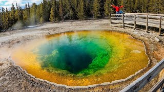
Old Faithful Lower General Store to Morning Glory Pool Bike Trail
Yellowstone National Park, Wyoming
12.2 miles W of Yellowstone National Park, WyomingThe biking trail from Old Faithful General Store to Morning Glory Pool is an easy paved bike trail with incredible views of the Upper Geyser Basin and a stunning destination. The trail to Morning Glory Pool is 2 miles round trip starting at the Old Faithful General Store. Before starting their journey, mountain bikers can stop and visit the Yellowstone must see that is Old Faithful and enjoy the ample parking available there.
From the General Store bikers will follow the UGB Biscuit Basin Trail. While enjoying this easy paved ride, visitors can take in the stark whites and rusty reds of the surrounding geyser basin. Morning Glory Pool is a sight to behold, with crystal clear water and a vivid range of colors that rival many of the more popular geysers.
The Old Faithful General Store to Morning Glory Bike Trail is perfect for mountain bikers of any skill level to enjoy a relaxing ride with stunning views.
2.8 mi
 Full Listing
Show more
Mountain Bike
Added on 9 Oct 2023
Full Listing
Show more
Mountain Bike
Added on 9 Oct 2023
Mount Washburn Bike Trail
Devils Den, Wyoming
5.5 miles SW of Devils Den, WyomingMount Washburn Bike Trail follows Chittenden Service Road for 2.5 miles to the top of Mount Washburn. This steep climb up the mountain provides a challenging elevation gain of 1500 feet. Mount Washburn is a popular hiking destination in Yellowstone, and the Mount Washburn Bike Trail provides an adventurous alternative to hiking, while still providing the sweeping views of Yellowstone from the top.
Mount Washburn Bike Trail is a wide dirt and gravel trail with a couple of switchbacks. It takes an average of two to five hours to complete this trail. Mountain Biker's should be aware of their surroundings as this is a service road and that will have occasion vehicles on it. Mountain bikes are no allowed on any of the nearby hiking trails and must stick to the Chittenden Service Road. Parking is available at the Chittenden Road Parking Area.
Mount Washburn is home to several species of wildlife, including black bears and grizzly bears. Visitors to this area should be on the lookout for wildlife and make sure to keep a safe distance. It is also recommended that visitors to this area carry bear spray with them.
4.0 mi
 Full Listing
Show more
Mountain Bike
Added on 31 Aug 2023
Full Listing
Show more
Mountain Bike
Added on 31 Aug 2023
Fountain Freight Road Bike Trail
Fountain Flats Drive / Freight Road Trailhead, Yellowstone National Park, WY 82190, USA
Fountain Freight Road Bike Trail is a four mile stretch of paved road along Fairy Falls Trail. This stretch of trail is no longer open to vehicles but allows bikes. Despite being paved, it is recommended that riders use mountain bikes for this trail.
Riders can ride this trail starting at either the Fairy Falls or Fountain Flat Drive Trail Heads, parking is available in both areas. This trail can be ridden as a four mile one way trail, or eight mile out and back.
This trail is fairly level and easy, leaving riders with the ability to enjoy the beautiful and varied scenery. The trail passes Goose Lake, crosses Firehole River and overlooks the Grand Prismatic Spring. This scenic ride is perfect for a variety of riders looking to experience the vast variety of beauty Yellowstone has to offer.
This trail takes riders an average of 2-4 hours to complete and is open in the summer and fall. Visitors here should keep a safe distance from any wildlife they may encounter.
8.4 mi
 Full Listing
Show more
Mountain Bike
Added on 31 Aug 2023
Full Listing
Show more
Mountain Bike
Added on 31 Aug 2023
Bunsen Peak Loop Bike Trail
Yellowstone National Park, Wyoming
35.5 miles N of Yellowstone National Park, WyomingBunsen Peak Loop Bike Trail is a challenging trail that follows several service roads around Bunsen Peak. This 10 mile loop has a total elevation change of 1,120 feet, with several miles of the trail being level and easier, and several miles with sharp elevation changes, sharp curves and steep drop offs. Overall, this loop is challenging and perfect for experienced mountain bikers.
The trail begins on Bunsen Peak Trail and Service Road, remaining relatively level for a few miles until joining Osprey Falls Trail. Riders looking for an easier ride can ride this part of the trail and turn back when the trail forks. The next 2.5 miles on Osprey Trail have the largest elevation gain, and most complicated switchbacks. Riders should follow Osprey Trail until they reach Glen Creek Service Road. This road will take riders back to Grand Loop Road and then to the parking lot.
Riders on this trail often spot a variety of wildlife, including bears, elk and bison. Riders should keep a large safe distance between themselves and the wildlife. It is recommended that visitors in this area carry and know how to use bear spray.
3.8 mi
 Full Listing
Show more
Mountain Bike
Added on 31 Aug 2023
Full Listing
Show more
Mountain Bike
Added on 31 Aug 2023
Abandoned Railroad Bed Bike Trail
Gardiner, Montana
0.5 miles W of Gardiner, MontanaThe Abandoned Railroad Bed Bike Trail, otherwise known as Shortline Trail, is a easily accessible bike trail found just inside the North Entrance of Yellowstone National Park. This bike trail follows an old railroad bed along Yellowstone River. The trail is 8 miles out and back and takes an average of two to four hours to complete. The stunning views of mountains, grassy plains and roaring river provide a picturesque background for an adventurous ride.
The trail can be found near the Heritage and Research Center in Gardiner Montana. There is a pull off on the road here with limited parking. Mountain bikers will need to walk their bikes from the parking area to the railroad bed. Once there the trail is gently sloping, made mostly of dirt and gravel with a few larger rocks. it is recommended that visitors bring tire sealant.
The Abandoned River Bed Bike Trail has a variety of wildlife that are often spotted here, including black and grizzly bears, elk and bison. Visitors should carry, and know how to use, bear spray and keep a large safe distance between themselves and the wildlife. Pets and Service Animals are allowed on this trail, but are not recommended and brought at your own risk due to possible dangerous wildlife confrontations.
0.3 mi
 Full Listing
Show more
Hike, Swim
Added on 31 Jul 2023
Full Listing
Show more
Hike, Swim
Added on 31 Jul 2023
Stony Kill Falls
Kerhonkson, New York
3.3 miles S of Kerhonkson, New YorkStony Kill Falls is a unique and hidden waterfall in the Shawangunks. Known mostly to locals this uncrowded area is the perfect place to visit to reconnect with nature.
The hike to the waterfall is 1.5 miles total and is moderately difficult, with some steep climbing over bigger rocks involved. The scenic hike through this rocky forest is well with te effort, with beautiful views to and from the waterfall.
Stony Kill Falls is and 87 foot waterfall that creates and impressive wispy spray. The cliff behind the waterfall is beautifully textured, with layers of multiple colors of rock and green growing moss. In the fall the forest surrounding the falls adds deep reds and yellows to this colorful experience. Stony Kill Falls is even beautiful to visit in the winter, often forming beautiful white and turquoise ice formations.
In the summer, the pool that forms below the falls is a great place to cool off. The moving water stays cold even in hot weather. Swimming and wading here is done at your own risk and swimmers should be careful of currents and slippery rocks.
Lake Minnewaska
Kerhonkson, New York
4.6 miles SE of Kerhonkson, New YorkLake Minnewaska is a beautiful family friendly place to swim in the summer months. With views of a stunning forest and towering white rock formations mirrored in the lake, the beautiful view makes this Lake Minnewaska a stunning place to see year round.
Swimming is open at a public beach here during the summer months between 11:15 am and 6:45 pm. The beach is made up of gravel beds that extend into the lake. The lake has three separate depths of swimming areas off, with roped the shallowest being only a few feet and the deepest being twenty feet deep. Swim shoes are reccommended for this rocky experience.
Lake Minnewaska is uniquely acidic, allowing for a different kind of aquatic and land animal life around the lake. Though the lake lacks actual fish there are several aquatic life species that are interesting for visitors to see. The species and water are all safe for swimmers.
Split Rock Hole
Gardiner, New York
5.1 miles NW of Gardiner, New YorkSplit Rock Hole is a unique swimming hole in the Mohonk Preserve. The beautiful landscape and variety in depth make this the perfect adventure for explorers of any age.
Split Rock Hole gets it's name from the ten foot chasm in the short cliffs leading to the waterfall. The water between these cliffs is crystal clear and about 5 to 8 feet deep. This allows swimmers to enjoy a proper swim while being able to clearly view the water all around them. The chasm leads to a 12 foot waterfall with a 3 foot deep pool beneath it. The pool is the perfect place to wade and play while enjoying a view of the picturesque waterfall and rocky cliffs. The cliffs are flat on top and allow for the perfect area for picnicking, sunbathing and viewing the water from above.
It is a short easy and beautiful hike to Split Rock Hole. Visitors should follow clove road and look for a sign that says "Coxing Entry". Here you will find a parking area where visitors will pay the Mohonk Preserve's entry fee. There is a picnic area and a bridge across the road, from which the swimming hole should be visible.
The forest, rocks and water here create uniquely stunning views that will make the perfect backdrop for your next adventure.
The Hudson off River Road
Lake Luzerne, New York
1.8 miles W of Lake Luzerne, New YorkOff of River Road on the outskirts of Lake Luzerne, the Hudson River has several sandy access points allowing visitors to enjoy the water. The trees along the sandy bank make a perfect backdrop for a variety of relaxing adventures.
Tubing, canoeing and kayaking are popular ways of enjoying this stretch of the river. The water here is calm allowing for a relaxing float, and the small sandy shore gives perfect put in and take out points for floaters to use.
The water here is also calm enough to be used for swimming. Sandy banks provide a place to picnic and rest. The clean water and easy access make this a wonderful place to enjoy the day.
Swimmers and floaters all enter the river at their own risk and should be cautious of currents and water depth. Visitors should not follow the water too far down stream, where Rockwell Falls is. The falls are dangerous to those swimming and floating downstream.
Spire Falls
Queensbury, New York
9.1 miles SW of Queensbury, New YorkSpire Falls is a swimming hole near Moreau State Park on the Hudson River. Created by Spire Falls Dam and surrounded by forest, this hidden swimming hole is a gem to enjoy.
Spire Falls Dam creates a small lake on the Hudson River flanked by rocky shores. The rocky shores create the perfect place for sunbathing and for entering the water to swim. The dam also calms the current, allowing for water calm enough to enjoy a leisurely swim.
Though there are often other swimmers here, Spire Falls is an unofficial swimming hole, and swimming is done at your own risk. Because of its unofficial nature, bathing suits are considered optional at Spire Falls and are often not worn by swimmers or sunbathers.
Fishing is allowed at Spire Falls Dam.
The parking area is a small pull off and can be found on the left hand side of Route 24 south of the dam. Swimmers can cross the road and follow a small path down to the water.
Cadron Creek
Damascus, Arkansas
6.5 miles SW of Damascus, ArkansasCadron Creek is a 10 mile long creek located near Buffaloe River. Cadron Creek has a variety of pools and rapids along it, making it the perfect location to visit for a wide variety of water activities.
Cadron Creek is best known for kayaking and canoeing routes. Each route has easy access points to the river for putting in and taking out boats, as well as rental and shuttle services available for those who don't have their own boats. The ride on Cadron Creek is never dull, ranging from a smooth scenic float to splashing rapids the creek is unexpected in its changes. Floaters will get wet. The rock formations, forests and even a couple of small waterfalls make this float scenic and unforgettable.
Caron Creek also allows for swimming and fishing. With some shallow pools perfect for family swimming, and some deeper pools perfect for rock jumping there is a swimming hole here for everyone. There are two popular and easily accesible swimming holes available here. One can be found in view of the Route 123 Bridge, and the other can be found near Pinnacle Spring Campground. Pinnacle Springs Campground has campsites, cabins and RV sites available for reservation for a fee.
Fishing is allowed on Cadron Creek with proper local permits. Fishers often catch large fish of the crappie, largemouth bass, bluegill and catfish varieties.
Those swimming, floating, or fishing on this river do so at their own risk and should be cautious of currents and slippery rocks.
Tyler Bend
Saint Joe, Arkansas
3.9 miles SE of Saint Joe, ArkansasTyler Bend Campground is a beautiful campground and swimming area near the old bridge on Route 65. The campground provides beautiful views of Buffalo National River with the white and orange rock cliffs on the other side. This campground is a wonderful place to reconnect with nature and enjoy a comfortable camping trip.
The campground has 28 drive-in sites, 10 walk-in sites, 5 group sites and a pavilion that are all available for reservation year round. The campground has a restroom with showers, potable water and a dump station available for campers. Campsite fees apply in the on season, March 15th through November 14th, but camping is free the rest of the year.
Near the campground is a rocky beach leading into Buffalo National River. This area is open for swimming and fishing. There is a parking lot available for those who wish to access the river during the day without camping. Kayaking and Canoeing are also allowed on the river, with locations to put in and take out available near Tyler Bend Campground.
×


