


Refine Search
- hike 74
- swim 56
- kayak 16
- canoe 14
- mountain bike 13
- camp 11
- horseback 3
- backpack 3
- whitewater 1
- snowshoe 1
- skateboard 1
- disc golf 1
120 locations
Add Location
 Full Listing
Hike, Swim
Added on 30 Apr 2022
Full Listing
Hike, Swim
Added on 30 Apr 2022
 Full Listing
Hike, Mountain Bike, Swim
Added on 30 Apr 2022
Full Listing
Hike, Mountain Bike, Swim
Added on 30 Apr 2022
 Full Listing
Canoe, Hike, Kayak, Mountain Bike, Swim
Added on 2 Dec 2021
Full Listing
Canoe, Hike, Kayak, Mountain Bike, Swim
Added on 2 Dec 2021
 Full Listing
Canoe, Kayak, Swim
Added on 31 Aug 2021
Full Listing
Canoe, Kayak, Swim
Added on 31 Aug 2021
 Full Listing
Canoe, Disc Golf, Kayak, Swim
Added on 31 Aug 2021
Full Listing
Canoe, Disc Golf, Kayak, Swim
Added on 31 Aug 2021
 Full Listing
Hike, Swim
Added on 25 Aug 2021
Full Listing
Hike, Swim
Added on 25 Aug 2021
 Full Listing
Camp, Hike, Horseback, Mountain Bike, Swim
Added on 9 Aug 2021
Full Listing
Camp, Hike, Horseback, Mountain Bike, Swim
Added on 9 Aug 2021
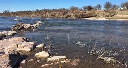
Buzzard Rock Hole
Strasburg, Virginia
4.5 miles SE of Strasburg, VirginiaBuzzard Rock Hole is a popular swimming hole in the forests below the famous Buzzard Rock. The hike to Buzzard Rock is a moderate hike that can be anywhere from 4 to seven miles depending on what path you decide to take. The Buzzard Rock is a beautiful mountain with unique rock formations as the top. These mountains provide a beautiful view for swimmers and hikers alike.
Buzzard Rock Hole is a clear, deep and cold swimming hole that is surrounded by a rock ledge that is perfect for sunbathing. Swimmers should be aware that the bottom of the swimming hole is rocky and shallow, making it unsafe to jump in. Swimmer should also be mindful of currents near the edges of the swimming hole.
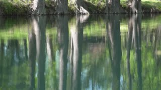
Mint Springs Valley Park
Crozet, Virginia
1.9 miles NW of Crozet, VirginiaMint Springs Valley Park is a beautiful eight acre park with a variety of activities to enjoy. The park has two small lakes with beaches and is surrounded by forests with miles of trails. The park also has reservable covered picnic table areas, a sand volleyball pit, and a playground.
The lakes are open for fishing year round, and are stocked with trout twice a year. The beaches are open year round for people wishing to relax on the shore, and are open for swimming during warmer months. Swim season information can be found on the park website. The forests surrounding the lakes create beautiful reflections on the lake and contain miles of trails open to hikers and mountain bikers.
San Marcus City Park
San Marcos, Texas
0.4 miles NE of San Marcos, TexasSan Marcus City Park is a popular cool off spot on the San Marcus River. This beautiful clear river is surrounded by lush greenery, giving beautiful views to those who walk the trails of this 18 acre park.
In addition to several miles of walking trails, the park has open basketball courts, a playground, restrooms and a picnic area. Making this the perfect spot to spend the day enjoying the outdoors with loved ones of any age.
San Marcus City Park is best known for it's river access point, allowing canoes, kayaks and other floating devices to enter and exit the water. Swimming is also enjoyed by many visitors. The access to this deep clear water makes this an irresistible destination for cooling off on warm days.
1.0 mi
 Full Listing
Hike, Swim
Added on 19 Oct 2021
Full Listing
Hike, Swim
Added on 19 Oct 2021
Gentleman's Swimming Hole
Oneida, Tennessee
7.8 miles W of Oneida, TennesseeGentleman's Swimming Hole is a popular hike and swimming hole in Big South Fork National Forrest. This section of the Clear Fork River Runs slow and is deep enough for an actual swim.
The hike to Gentleman's Swimming Hole is a longer easy trail that is great for families with children. The hike is two miles in total. The first mile will take you out to your relaxing swimming hole and the second mile will bring you home once you have finished splashing around. The trail goes through the forest from Laurel Dale Cemetery to Clear Fork River, branching to the right a quarter mile from the end of the trail. From here the trail goes along a thin stretch of land between the cliffs and the river making for a spectacular view.
Castell Crossing
Llano, Texas
17.2 miles W of Llano, TexasCastell Crossing is a 950 foot stretch of riverfront on the Llano River that is open from 30 minutes before sunset to 30 minutes after sunset. This is the perfect place to spend the day enjoying the beautiful clear water and walking along the rocky shore.
This stretch of river is the perfect launching or returning point for Kayaks and Canoes. Any non-motorized boats or floating devices are allowed on the river.
Castell Crossing is a popular fishing spot for bank fishing as well as boat fishing. Guadalupe Bass, Largemouth Bass, Channel Catfish and Sunfish are all commonly found on this stretch of the Llano River.
Swimming is also allowed on this section of the river, but is done at your own risk. The river is shallow and slow moving towards the edge, but can become deeper and faster moving toward the center. Swimmers should exercise caution while swimming in the river.
With so many activities to enjoy Castell Crossing is the perfect way to spend a sunny day.
Sewell Park
San Marcos, Texas
0.6 miles NE of San Marcos, TexasSewell Park is the perfect place too cool off on a hot day. The park is located on Texas State University campus along the crystal clear San Marcos River. Visitors can enjoy the 72-degree water by taking a cooling swim or floating in tubes, kayaks or canoes. Rentals are available at the Outdoor Center or visitors may bring their own.
Visitors who need a rest from the water will find several activity areas open on land. There are two sand volleyball courts, open fields for frisbee, an outdoor basketball court and picnic areas. These are all free and open to the public.
There are several spaces in the park that can be reserved for classes and larger gatherings. These reservations cost a fee and can be made online.
Blue Hole at Wimberley
Wimberley, Texas
0.8 miles NE of Wimberley, TexasBlue Hole Regional Park is a beautiful forested spot that has been preserved by the City of Wimberley and is a popular destination for locals. The clear blue water and spectacular cypress trees make this a wonderful place to cool off in the warm weather. The park provides rope swings for visitors. There are regular rope swings for beginners as well as a more advanced rope swings for swimmers seeking a challenge. The swimming Hole requires a reservation that can be made online, and costs $12 for adults and $6 for seniors and youth under 13.
Blue Hole also has 4.5 miles of hiking trails that are free and open to the public. These trails are flat and well shaded, making for easy family friendly hiking. The park also has a sand volleyball court, basketball court, pavilion, picnic areas, and a playscape for children that are free and open to the public.
Pedernales Falls
Johnson City, Texas
10.3 miles NE of Johnson City, TexasPedernales Falls is a tranquil swimming hole in the beautiful Pendernales Falls State Park. The park is known for the stunning limestone formations and waterfalls created by the Padernales River. Downstream of the cascading falls the river calms and flows in a series of pools. These pools vary in depth and are perfect for wading and swimming in the cool water. Several swimming spots can be found along the river.
Parking is available by the waterfall, and several swimming spots are located an easy hike downstream. Pendernales State Park has several hiking and camping areas surrounding the river, including campgounds with water and electricity as well as a primitive camping area. The primitive camping are is located two miles down Wolf Mountain Trail. There is also an equestrian trail with it's own parking lot available.
With the stunning views and engaging activities Padernales Falls is a great place to cool off for the day or explore for the weekend.
Entrance fees for the State Park are $6.00 for visitors age 13 and older (12 and under enter free). Swimming is restricted by the waterfall and only permitted downstream where water is clammer. Swimming is at your own risk as no lifeguards are on duty. Please review the park's safety guidelines before swimming.
1.4 mi
 Full Listing
Hike
Added on 4 Apr 2019
Full Listing
Hike
Added on 4 Apr 2019
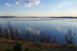
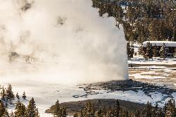
Yellowstone Lake Overlook Trail
Grant Village, Yellowstone National Park
1.4 miles N of Grant Village, Yellowstone National ParkYellowstone Lake Overlook Trail is a 1.7 mile loop trail that is easy and great for beginner hikers. The trail begins near the West Thumb Geyser Basin Parking Lot and is open in the summer and fall.
16.9 mi
 Full Listing
Hike
Added on 4 Apr 2019
Full Listing
Hike
Added on 4 Apr 2019
Specimen Ridge Trail (2K4)
Buffalo Ford, Wyoming
1.0 miles SW of Buffalo Ford, WyomingSpecimen Ridge Trail is a challenging hike that requires navigational and technical skills to complete. This 17 mile hike is remote, and though it is marked by carins and blazes, it is often overgrown and difficult to see.
Hikers should also be aware that the hike ends with crossing a river ford, that is sometimes not passable making hikers have to turn around, turning a 17 mile hike into a 35 mile hike. Though this can be an exciting challenge and unique feature of this hike, hikers need to be skilled and ask ahead for information about the ford's current conditions.
The hike begins at the Specimen Ridge Trailhead, on North East Entrance Road. There is parking available at the trailhead. This hike passes through rocky and heavily forested terrain, providing shade for hikers. The trail ascends 3,000 feet over the next several miles to Amethyst Mountain. The elevation gain and rocky terrain make this trail an advanced challenge for avid hikers. After reaching the peak of Amethyst Mountain and enjoying the views hikers will descend several miles into Lamar Valley, before finally reaching and crossing the Lamar River, and ending at the Lamar River Trailhead.
This hike is meant to be a day hike, with no established campgrounds for overnight stay. Hikers should be prepared with enough food and water for this hike, as well as have readily accessible bear spray with them.
8.5 mi
 Full Listing
Hike
Added on 4 Apr 2019
Full Listing
Hike
Added on 4 Apr 2019
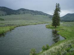
Slough Creek Trail
Tower Junction, Yellowstone National Park
5.6 miles E of Tower Junction, Yellowstone National ParkSlough Creek Trail is a 3.4 mile out and back trail that follows a historic wagon trail through several meadows. This trail is a fairly easy hike that has beautiful views of Slough Creek. The trailhead can be found on the dirt road to Slough Creek Campground. The trail is open in the summer and the fall.
2.4 mi
 Full Listing
Hike
Added on 4 Apr 2019
Full Listing
Hike
Added on 4 Apr 2019
Lost Lake Trail
Tower Junction, Yellowstone National Park
0.3 miles SW of Tower Junction, Yellowstone National ParkLost Lake Trail is a 2.8 mile hike that can be completed in less than two hours. This is an easy hike with very little elevation change. Hikers can enjoy forests, meadows and a view of Lost Lake along this trail. This trail is open year round. The trailhead is located behind Rosevelt Lodge.
8.2 mi
 Full Listing
Hike
Added on 4 Apr 2019
Full Listing
Hike
Added on 4 Apr 2019
Garnet Hill Trail
Tower Junction, Yellowstone National Park
0.2 miles E of Tower Junction, Yellowstone National ParkGarnet Hill Trail is a 7.6 mile loop that follows an old, dirt stagecoach road. This trail passes through large meadows, dusty areas with sagebrush, forests and beside the Yellowstone River. This area has an abundance of wildlife, including wolves, bears, moose, bison, badgers and elk. Hikers should watch for signs of wildlife and keep a safe distance from all animals. This trail is open year round. The trailhead can be found near Tower Junction where North Entrance Road and Grand Loop Road Cross.
1.5 mi
 Full Listing
Hike
Added on 4 Apr 2019
Full Listing
Hike
Added on 4 Apr 2019
Observation Point Trail
Old Faithful, Yellowstone National Park
0.1 miles S of Old Faithful, Yellowstone National ParkObservation Point Trail is an just over 2 mile loop that passes several geysers along the way to Solitary Geyser. Observation Point Trail provides up close views of several geysers as well as a spectacular view of Old Faithful herself.
This trail, despite beginning in a very popular area of Yellowstone, has very little foot traffic. Because of this, Observation Point Trail is the ideal way to visit Old Faithful. Hikers on this trail will be able to see a sweeping view of Old Faithful from above while avoiding the crowds that typically gather for this popular geyser. The trail ends with a view Solitary Geyser and the Upper Geyser Basin.
The trailhead can be found to the right on the boardwalk of Old Yellowstone across the Firehole River Bridge. This trail is open year round. Because of thermal activity it is imperative that hikers stay on the established paths and boardwalks.
2.0 mi
 Full Listing
Hike
Added on 4 Apr 2019
Full Listing
Hike
Added on 4 Apr 2019
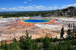
Grand Prismatic Spring Overlook Trail
Old Faithful, Yellowstone National Park
3.8 miles N of Old Faithful, Yellowstone National ParkThe Grand Prismatic Spring Overlook Trail gives hikers an opportunity to see the famous aerial view of the Grand Prismatic Spring. The vibrant rainbow waters of the Grand Prismatic Spring are best viewed from above.
The forested trail provides for a invigorating, short hike up to the overlook. From the overlook hikers have a sweeping view of the entire Midway Geyser Basin. Seeing this active geothermal area from above provides a unique perspective that you don't want to miss. This geyser basin is famous for the variety of color that can be seen here.
The Grand Prismatic Spring Overlook Trail is a 1.2 mile out and back hike that can be completed in less than 2 hours. The trail has some steep incline to get to the viewing point, but most hikers can tackle the hike. This trail is open in the winter, summer and fall, and closed in the spring. This hike is one of the more popular hikes in Yellowstone, so hikers will not be hiking alone.
The trailhead is located in the Fairy Falls Parking Lot, one mile south of the Midway Geyser Basin.
The Grand Prismatic Spring Overlook Trail is the best trail to take for view of the Grand Prismatic Spring and Midway Geyser Basin.
6.2 mi
 Full Listing
Hike
Added on 4 Apr 2019
Full Listing
Hike
Added on 4 Apr 2019
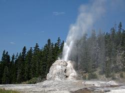
Howard Eaton Trail
Old Faithful, Yellowstone National Park
0.5 miles S of Old Faithful, Yellowstone National ParkThe Howard Eaton Trail in the Old Faithful Area is a hike with incredible geothermic features and other natural views. This hike is a moderately difficult 6.5 mile there and back trail, that begins near the Old Faithful Geyser.
Along the trail hikers will be able to hike up a burned hill, through spruce-fir forests and past several interesting geysers and springs. This hike culminates in the viewing of Lonestar Geyser, an impressive geyser that erupts approximately every three hours. Lonestar Geyser is built up into an impressive, little, white sulfur mountain that erupts like a volcano from its top with steam and water.
Howard Eaton Trail is open in the winter, summer and fall and closed in the spring. Because of the geothermal activity in this area it is imperative that hikers stay on designated trails throughout there hike. It is dangerous to leave the trails. Hikers should also be on the lookout for bears in the area. If bears are spotted hikers should maintain a safe distance from them.
The trailhead can be found across Grand Loop Road from the Old Faithful Ranger Station.
Howard Eaton Trail is a wonderful addition to an afternoon in the Old Faithful area of Yellowstone National Park. Hikers who enjoy the geothermal features of the park will enjoy viewing Lonestar Geyser and the other sights along the way.
2.1 mi
 Full Listing
Hike
Added on 4 Apr 2019
Full Listing
Hike
Added on 4 Apr 2019
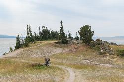
Storm Point Trail
Lake Village, Yellowstone National Park
3.4 miles E of Lake Village, Yellowstone National ParkStorm Point Trail is a beautiful 2.3 mile hike that can be completed in under 2 hours. This is an easy hike with very little elevation change that is perfect for families with children.
Hikers on Storm Point Trail will enjoy hiking along the shores of Yellowstone Lake and Indian Pond and witnessing the beautiful waterfront views and wildlife. This trail takes hikers through the green meadows neighboring the lake and pond to Storm Point. Storm Point is a rocky, windy overlook to Yellowstone lake. It is easy to feel connected no nature in this area with these refreshing views along this relaxing hike.
This hike is open in the summer and fall, it is closed in the winter due to heavy snow. In the spring and from time to time in the summer Storm Point Trail will be closed due to heavy bear activity. Visitors wanting to hike this trail may inquire if the trail is closed at the Fishing Bridge Visitor Center. No matter what season it is, hikers should be cautious of bears and keep a safe distance when a bear is spotted.
The trailhead can be found at the Indian Pond Pullout, 3 miles east of the Fishing Bridge Visitors Center.
Storm Point Trail is a wonderful out and back hike with spectacular views. Visitors to Yellowstone wishing for a unique view of Yellowstone Lake will enjoy hiking this trail.
7.4 mi
 Full Listing
Hike
Added on 2 Apr 2019
Full Listing
Hike
Added on 2 Apr 2019
Pelican Valley Trail
Lake Village, Yellowstone National Park
3.4 miles E of Lake Village, Yellowstone National ParkPelican Valley Trail is a beautiful 6.2 mile hike that allows hikers to see Yellowstone Lake, Pelican Springs and the Pelican Valley water features. Despite its length this is an easy, level trail.
The trail begins by going over several bridges and through a forest. Once past the forest hikers can enjoy Pelican Valley with its winding creek and marshy lands. Pelican Valley is a unique feature in Yellowstone that visitors won't want to miss.
This area of Yellowstone is some of the best grizzly bear country. Because of this the trail has many closures for safety of visitors. The trail is only open during summer and fall months, starting on July 4th and may only be hiked during daylight hours. It is imperative that hikers stay on the trail and keep a look out for and safe distance from any bears that they may encounter.
The trailhead for Pelican Valley Trail is located off of a gravel road that is 3 miles east of the Fishing Bridge Visitors Center.
Pelican Valley Trail is the perfect hike for Yellowstone Visitors looking for a long, leisurely and unique hike. The creeks, streams and marshy lands make this trail look different than any other in the park, making this the perfect hike to add to any Yellowstone visit.
0.6 mi
 Full Listing
Hike
Added on 2 Apr 2019
Full Listing
Hike
Added on 2 Apr 2019
Pelican Creek Nature Trail
Lake Village, Yellowstone National Park
1.7 miles E of Lake Village, Yellowstone National ParkPelican Creek Nature Trail is a beautiful easy walk that gives visitors views of Yellowstone Lake and Pelican Creek. This family friendly trail can be completed in under an hour.
Despite the shortness of the trail, the variety of views available from the trail make this a hike worth taking. In the short 0.6 mile loop hikers will see streams, forests, and the immensity of Yellowstone Lake. Many varieties of water fowls are native to this area and can be spotted along the trail, including grebes, pelicans and teals.
The 0.6 mile loop can be easily walked by hikers at any level. There is little change in elevation and the path is well marked and easy to follow. This loop is moderately trafficked, but can be quieter at sunrise and sunset, beautiful times to visit the lake. Pelican Creek Nature Trail is only open during the summer and fall months due to heavy snow in the winter and spring.
The trailhead for Pelican Creek Nature Trail can be found on the west end of the Pelican Creek Bridge.
Visitors to Yellowstone National Park looking for a breathtaking, relaxing hike will enjoy walking along Pelican Creek Nature Trail. This trail provides hikers with an up close view of Yellowstone Lake that is sure to be unforgettable.
2.3 mi
 Full Listing
Hike, Mountain Bike
Added on 2 Apr 2019
Full Listing
Hike, Mountain Bike
Added on 2 Apr 2019
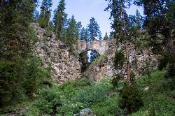
Natural Bridge Trail
Lake Village, Yellowstone National Park
2.6 miles SW of Lake Village, Yellowstone National ParkNatural Bridge Trail is an exciting and easy 2 mile trail to the beautiful rock formation that is Natural Bridge Yellowstone. This Natural Bridge was formed by Bridge Creek as it wore a hole in the rhyolite rock cliff.
This gray bridge has beautiful views through the hole of the bridge on either side and plant life growing over the top of it. The best views can be obtained by hiking around to the back of the Natural Bridge. The trail leading to the bridge is level and passes through forests and meadows, giving visitors views of the Bridge Bay Marina through the trees.
The trail follows Natural Bridge Road, and allows hiking and mountain biking on the road. This trail is great for beginner mountain bikers with a gravel and dirt path and little elevation change. Visitors should keep an eye out for occasional service vehicles.
Bears can often be seen in this area. They love to feast on the trout in Bridge Creek. Hikers and mountain bikers should keep an eye out for these animals and keep a safe distance when they are spotted.
The trailhead can be found near the Bridge Bay Marina parking lot. The trail is only open during the summer and fall.
Natural Bridge Trail is an easy out and back trail that can be completed in less than 2 hours and rewards hikers with an amazing view of Yellowstone's Natural Bridge. The ease of the trail and the entertaining views make this a perfect trail for families with children.
×


