


4.2K Portfolio by tasiawhicker
first prev 1 2 next last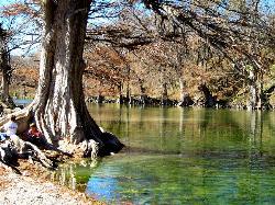
Guadalupe River State Park
Spring Branch, Texas
5.1 miles W of Spring Branch, TexasGuadalupe River State Park is a wonderful place to enjoy the beautiful Guadalupe River and the land around it.
The park has over 4 miles of river front where visitors can enjoy swimming, fishing, wading in the water, sitting on the shore, kayaking, and canoeing. The river varies in depth allowing for these different activities. People of all ages will enjoy the variety available on the river.
Floating on tubes over the calmer parts of the river is an activity that is enjoyed by many. Don’t own a tube? Rentals are available at the park.
Guadalupe River State Park also features over 13 miles of trails available to hikers and mountain bikers. A few of these trails also allow for horseback rider access, including the Painted Bunting and River Overlook Trails.
There are 85 campsites at the park available for reservation. These campsites have water and electricity available for RV and tent campers. Nine additional primitive campsites are available for walk-ins on a first come first served basis. These primitive campsites do not have water or electricity, allowing campers to enjoy being more connected to nature.
The entrance fee to the Guadalupe River State Park is 7 dollars per person. Children 12 years old and younger can enter the park for free.
Guadalupe River State Park is a wonderful place for the citizens of Austin, Dallas and other surrounding cities to escape and enjoy the great outdoors many times over.

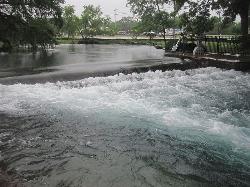
Nichol's Landing
New Braunfels, Texas
21.9 miles NW of New Braunfels, TexasNichol’s Landing is a unique spot on the Upper Guadalupe River. Nichol's Landing is the area where the Upper Guadalupe River can be accessed with the most ease. Unlike most other access areas, Nichol's Landing had off road parking close to the river, making it easy to reach the river without strenuous hiking.This ease of access makes Nichol’s landing a unique and valuable put in or take out point for kayaks and canoes.
The depth and rapids on the Upper Guadalupe River vary from day to day. Most of the time beginners can navigate these waters in canoes, kayaks or tubes.
In addition to being a great point to begin or end a floating journey, Nichol’s landing is a great swimming hole. There is a sandbar that narrows the river into a smaller channel and a rope swing hanging from a cypress tree.
The Upper Guadalupe River is lined with beautiful cypress trees and limestone shelves. These unique views can be enjoyed by visitors as they participate in their various activities.
Fishing is allowed at Nichol’s Landing. This section of the Guadalupe River is home to several types of bass, carp, crappie, gar and catfish. Small lures and a light line are recommended and Texas fishing regulations apply.
Before participating in any activity on this river, it is recommended that visitors check the rate of the rivers flow. The river is safe for any activity when its flow is between 100 and 800 cubic feet per second. Flow rates can be found online using www.wordcc.com or waterdata.usgs.gov.
Whether you are swimming, fishing, floating or paddling you will enjoy your day on the Upper Guadalupe River at Nichol’s Landing.
Landa Park
New Braunfels, Texas
1.0 miles NW of New Braunfels, TexasLanda Park is a 50-acer, beautiful respite for locals and visitors alike. With its many uniquely charming attractions, this park is a place you will want to visit and revisit many times over.
Landa Park is known for the beautifully clear water in its lake and streams. Visitors can enjoy the water in many different ways. There are extensive paved and unpaved walking trails to explore and see every unique view. From the beautiful bridges to the historic gazebo, the paths around Comal Springs are a charming and peaceful place to walk, ride bicycles or skateboard.
Visitors can also enjoy the clear water by fishing at the Fishing Pier on Landa Lake. Fishers are welcome to use a regular rod and reel to fish in this area. A state fishing license and freshwater fishing stamp are required.
For visitors wanting to enter the water there are 3 spring fed pools they can enter. These pools are shallow and great for children. One of these three pools is a wading pool located on the Comal River, or Landa Lake. The water is a pleasant 72 degrees year-round.
During the summer months, visitors can rent a paddleboat to explore Landa Lake and the Comal Springs. Paddleboat rentals are 3 dollars a person for a 30-minute paddle. A minimum of two tickets are required to be purchased. Children 3 years old and younger are free.
Visitors looking for a more unique and complete view of the park can buy a ticket for the Landa Park Miniature Train. During summer months the train is open daily. During other months of the year the train is open on weekends and holidays. Train tickets are 4 dollars per person. This train is an enchanting experience for young children.
The Landa Park Mini Golf Course is open similar hours to the train and costs 4 dollars a person.
The variety of activities available make Landa Park a wonderful place to spend any day of the year. Come and enjoy a day in the shade of the ancient oak trees gazing at the crystal waters.

Cypress Bend Park
New Braunfels, Texas
1.3 miles NE of New Braunfels, TexasCypress Bend Park is a leafy 15-acre riverfront park on the banks of the Guadalupe River in New Braunfels, Texas, named for the towering bald cypress trees that lean over the water and shade its gravel banks. It's a favorite local spot to slip into the river away from the tube-rental crowds of the Comal and the Guadalupe's busier put-ins — a place where New Braunfels families come to wade, picnic and cool off on a hot Hill Country afternoon. The river here runs clear and green over a gravel-and-limestone bed, with shallow edges for kids and deeper pockets under the cypress roots for a proper dip.
The park pairs its river frontage with a full set of dry-land amenities. There are open playing fields, a children's playground, horseshoe pits, picnic tables and scattered shade, plus restrooms and parking — enough to make a full day of it rather than a quick swim stop. The cypress-lined bank gives the whole park a cool, cathedral feel even at midsummer, and the mostly flat, grassy grounds make it easy for families arriving with young kids, coolers and folding chairs.
Swimming and wading are the main draw, and the Guadalupe is also a popular spot here for fishing — the deeper holes hold Guadalupe bass, sunfish and catfish, and the park's gentle banks make for easy casting. Tubers and kayakers pass through on the current, and the park is a pleasant put-in or take-out for a mellow float on this stretch of river. The Guadalupe's level and speed swing hard with upstream dam releases and rain — a calm green ribbon one day can run fast and murky the next — so it's worth checking conditions before letting kids into the water and keeping an eye on the current after storms. The bottom is rocky and slick in places; water shoes save toes and footing.
Because it's a city park rather than a commercial outfitter's landing, Cypress Bend stays quieter and cheaper than the marquee tubing chutes nearby, though it can still fill on summer weekends and holidays. There is no charge to swim, and the setting rewards an early arrival — mornings are calm and shaded, and the cypress canopy keeps the bank comfortable long after the surrounding streets have baked. Spring through early fall is prime season for getting in the water; the cypress turn rusty-gold in late autumn, making even a cool-weather stroll along the bank worthwhile.
New Braunfels sits at the heart of the Texas Hill Country between Austin and San Antonio, so Cypress Bend pairs naturally with a longer river day — a float on the Guadalupe or Comal, a visit to the historic Gruene district, or a stop at one of the region's swimming holes. Pack water shoes, sun cover for the open fields, and a cooler; bring a trash bag and carry out what you bring, since the park's easygoing character depends on visitors keeping the riverbank clean.

Purple Mountain Trail
Madison, Yellowstone National Park
0.4 miles E of Madison, Yellowstone National ParkPurple Mountain Trail is a 6 mile out and back trail to the peak of purple mountain. This is a beautifully forested trail with little foot traffic is a quiet respite from the crowds of Yellowstone.
The trailhead is located just east of Madison Campground, and a quarter mile north of Madison Junction. Purple Mountain Trail has a steady incline. Hikers climb 1,500 feet in three miles. This steady incline makes Purple Mountain Trail a challenging hike.
At the beginning of the hike the trail is heavily forested. Purple mountain trail is quiet, allowing hikers to connect with nature as they climb. As the trail ascends the trees thin giving hikers more views of the valley. From the top of the trail hikers can view the Madison and Gibbon rivers. The panoramic view available from the top of the trail is one you don’t want to miss.
Purple Mountain Trail is only open during the summer and fall months due to heavy snow in the winter and spring.
This hike is an exciting adventure to add to any visit to Yellowstone National Park. Visitors who camp at Madison Campground will enjoy the proximity to Purple Mountain Trail. The peak of Purple Mountain is an exciting destination for your hiking bucket list.

Harlequin Lake Trail
Madison, Yellowstone National Park
1.2 miles W of Madison, Yellowstone National ParkHarlequin Lake Trail is a beautiful short hike that can be taken in under an hour. This scenic hike is easy and family friendly, making it the perfect activity to add to any Yellowstone visit.
The trail begins on Highway 191 just west of Madison Campground and Madison Canyon. There are several pullout areas near the trailhead where parking is available. Harlequin Lake Trail is approximately a half mile there and back. The trail is level and well established, making this a walk for hikers of any level.
The trail is surrounded by a pine forest made up of both large old trees and small new ones. Hikers on Harlequin Lake trail can also enjoy a view of the small, pine covered mountains in the distance.
At the end of the trail hikers enjoy a close-up view of Harlequin Lake. The lake is covered in lily pads with colorful flowers, and several varieties of waterfowls are frequently seen on the lake. This lake is named after the Harlequin duck that can be frequently seen in this area.
Despite its proximity to the highway, this beautiful hike is quiet and low in traffic making this a wonderful respite from the crowds that often occupy the busier Yellowstone areas. This easily accessible and walkable hike to Harlequin Lake is one you won’t want to miss.
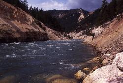
Seven Mile Hole Trail
Canyon Village, Yellowstone National Park
1.0 miles SE of Canyon Village, Yellowstone National ParkSeven Mile Hole is a challenging out and back trail that winds along and into the Grand Canyon of Yellowstone. This 10-mile hike begins and ends at Canyon Village where parking is available.
From Canyon Village, Seven Mile Hole Trail goes along the canyon rim. Hikers can enjoy views of Silver Cord Cascade as they walk along this first section of trail. About three miles into the hike the trail turns and descends into the canyon. This decent is 1,000 feet in 2.3 miles making this trail an exciting challenge for hikers.
Once hikers finish their decent into the canyon, they can enjoy a new perspective of the canyon from Seven Mile Hole. The canyon walls are beautiful and colorful from the bottom and the up-close view of the Yellowstone River is inspiring.
Along Seven Mile Hole Trail there are several active and dormant hot springs. This thermal activity creates beautiful views but can also be a safety hazard. Hikers should remain on the established trails.
The return hike to Canyon Village is the most difficult part of hiking Seven Mile Hole Trail because of the steep ascent as hikers emerge from the canyon. Hikers sometimes opt to take the trail in two-day chunks and camp overnight. There are several campsites available for reservation through Yellowstone. Campers should come prepared with food, water and other supplies as these are primitive campsites.
The stunning views of the Grand Canyon of Yellowstone and the challenge of the hike make Seven Mile Hole Trail an adventure to add to your bucket list.

Matt Hughes Skate Park
Myrtle Beach, South Carolina
2.1 miles NE of Myrtle Beach, South Carolina
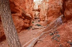
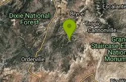
Mossy Cave
Tropic, Utah
3.2 miles NW of Tropic, UtahMossy Cave Trail is perfect for Bryce Canyon Visitors who want to experience the wonderful rock formations, like the Hoodoos, without steep and strenuous climbing. This trail is just over a mile and is an easy hike that can be taken with very little time. Children and senior citizen can take this trail without strain.
This hike is not only easy, but it is also beautiful. Hikers can see the red rock formations that Bryce Canyon is famous for, as well as some more unique water features. Mossy Cave Trail neighbors a charming stream. Hikers wishing to cool off can wade in the water and follow the trail. Be sure to bring water shoes.
The path leads right to the famous Mossy Cave. During the warmer months of the year Mossy Cave has a waterfall descending from the cave’s top rim. This waterfall is stunning against the backdrop of the green moss-covered cave and the red rocks. During the winter the waterfall turns into a cascade of icicles that cover the entrance to the cave.
The Mossy Cave Trail is a wonderful trail to hike and see a different side of Bryce Canyon. The unique water features and leisurely trail make this a wonderful addition to any Bryce Canyon visit.

Beaver Ponds Trail
Mammoth, Yellowstone National Park
0.3 miles SW of Mammoth, Yellowstone National ParkBeaver Ponds Trail is a wonderful short hike accessible from Mammoth Hot Springs. The trail forms a loop between the two trailheads available at Mammoth Hot Springs. The loop is just over 5 miles with a 650-foot elevation gain and can be completed in 2 to 5 hours.
Hiking Beaver Ponds Trail provides the hikers with some spectacular views, including a unique, distant perspective of Mammoth Hot Springs. This trail is famous for the four ponds that are visible to hikers. These ponds vary in sizes. The largest pond, Beaver Pond, is at the hook of the loop. The smaller ponds are surrounded with reeds and coated with algae in the summer months.
There is abundant wildlife to be seen on Beaver Ponds Trail. Elk and Beavers frequent the area surrounding the trail. Wildflowers and birds can also be seen from the trail. Black bears and grizzly bears are occasionally in the area. Be cautious and safe by keeping your distance around the wildlife.
The trail is easy to follow and great for hikers of all levels. Hiking Beaver Ponds Trail is a wonderful addition to any Yellowstone or Mammoth Hot Springs visit. This short hike is great to take in the morning or evening.

Mammoth Hot Springs Campground
Mammoth Hot Springs, Yellowstone National Park
0.3 miles E of Mammoth Hot Springs, Yellowstone National ParkMammoth Hot Springs Campground is the only campground in Yellowstone that is open to campers year-round. Campsites cannot be reserved and are available on a first come first served basis. It is located 5 miles into Yellowstone National Park from the North Entrance near the Mammoth Hot Springs Terraces.
The campground has 85 campsites that are available for tent and RV campers. RV parking lengths are 60 feet in the summer and 30 feet in the winter. There are no hookups or dumpsites in the campsite. The closest dumpsite is 5 miles away, just outside the park. Generators are available between 8 a.m. and 8 p.m. for campers to use.
Mammoth Hot Springs Campground has restrooms available for campers with flushing toilets as well as restrooms with vault toilets. Showers are not available directly in the campsite, but there are showers in the Mammoth Hot Springs area that campers can use.
Because of its location the Mammoth Hot Springs Campground is a wonderful place to stay for a trip to Yellowstone. It is a great central base for visiting Mammoth Hot Springs and Yellowstone’s other unique attractions. Campers can also enjoy hiking and fishing in the surrounding area where several fishing holes and hiking trails can be found.
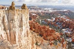
Rim Trail
Bryce, Utah
3.2 miles S of Bryce, UtahRim Trail is a wonderful way for hikers to explore the breathtaking views of Bryce Canyon from above the canyon. The trail curves around the park allowing hikers to view the spectacular, red rock formations from every major viewing point. Rim Trail Serves as a connection between major viewing points and trails throughout the park.
Hikers typically start hiking the trail at Fairyland Point and finish at Bryce Point. The entire trail between these points is 5.5 miles one way, or 11 miles out and back. Despite its length this trail is considered one of the easier trails in Bryce canyon. It is relatively level with gradual inclines and declines.
Hikers who don’t wish to hike the entire trail can start and end at any of the viewing points along the trail. A commonly hiked portion of the trail is between Sunrise Point and Sunset Point. Between these two points the trail is half a mile, or one mile out and back. This section of the trail is paved and is wheelchair accessible in good weather.
Rim Trail is a great access point to many trails down into the rock formations, or Hoodoos. Queens Garden Trail, Fairyland Loop Trail, and Peek-A-Boo Trail are all accessible from Rim Trail and make great additions to any hike.

Bristlecone Loop
Kanab, Utah
33.5 miles NE of Kanab, UtahBristlecone Loop is a one-mile trail from Rainbow Point. Rainbow Point is located at the southern end of Bryce Canyon National Park and is the highest point in the park. The spectacular views overlooking the park can be enjoyed as hikers meander this easy trail.
Bristlecone Loop is named for the Bristlecone Trees that can be found along the pathway. These trees are unique in their age and beauty. The oldest Bristlecone Trees on this path are estimated to be 1,800 years old. Be sure to take in the view of their uniquely spiky pinecones.
The beginning portion of this trail is forested with Blue Spruce, Douglas Fir and White Fir Trees. These trees provide a great habitat for many forms of wildlife. Hikers commonly see woodpeckers, blue jays, chipmunks, owls and squirrels on Bristlecone Loop.
The middle of the loop provides a wonderful view off the top of the highest cliff in Bryce Canyon. This unique perspective of the park is definitely worth the hike.
Hikers wanting to explore Bristlecone Loop can park at Rainbow Point and easily find the well-marked trailhead on the east side of the parking lot.
Bristlecone Trail is a wonderful way for hikers of all skill levels to experience the views and wildlife available in Bryce Canyon National Park.
Navajo Trail
Bryce, Utah
3.6 miles S of Bryce, UtahNavajo Trail explores the main amphitheater of Bryce Canyon National park in a short but winding hike. The hike begins at Sunset Point and splits off into a loop. The loop can be taken in either direction and is about one and a half miles in length. This trail is moderate in difficulty, with some steeper rocky parts.
Hiking Navajo Trail will take you down to experience up close the rock formations that make Bryce Canyon famous, the Hoodoos. These red formations will begin to tower over you as you descend into the amphitheater.
Navajo Trail provides hikers with access to three of the parks most famous formations. The Thor’s Hammer, Twin Bridges and Wall Street formations can be seen from the trail.
Along the trail you will be able to see huge Douglas Firs growing out from the rock. The green, life-filled trees provide an incredible contrast to the dry red rocks around them. The trees have been growing here for more than 750 years.
The winding loop created by Navajo Trail can be completed in one to two hours. For hikers looking to experience Navajo Trail while also wanting a longer hike can combine Navajo Trail with Queens Garden Trail for a 3 mile adventure.
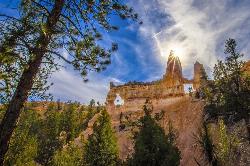
Tower Bridge
Bryce, Utah
3.3 miles S of Bryce, UtahTower Bridge is a unique and uncrowded trail in Bryce Canyon. Tower Bridge gets its name from the prominent rock formation the trail leads to. The rock formation resembles London Bridge and is a sight worth visiting.
Along the trail to Tower Bridge hikers can get close views of the rock formations that make Bryce Canyon famous. The trail becomes progressively less crowded the further you hike from Sunrise Point.
The trail to Tower Bridge begins at Sunrise Point and goes North East along Fairyland Loop. On Fairyland Loop a detour trail is marked off to Tower Bridge.
The trail from Sunrise Point to Tower Bridge is 3 miles out and back and is considered moderately difficult. The beginning of the trail from Sunrise Point descends rapidly and is the most difficult part of the trail.
Hikers wishing to see Tower Bridge can also hike the entirety of Fairyland Loop. This method of access is longer. The loop is 8 miles long and more difficult than the out and back trail.
The hike to Tower Bridge is perfect for hikers wanting to experience the beautiful red rocks Bryce Canyon is famous for as well as some less explored sights. The impressive natural bridge that is Tower Bridge is a unique sight in Bryce Canyon and adds variety to any trip to the park.

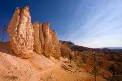
Hat Shop
Bryce, Utah
4.8 miles S of Bryce, UtahHat Shop Trail is a moderately difficult hike with the view of some delicately balanced rock formations. These rock formations are where the Hat Shop Trail got its name. Huge gray boulders can be found balancing on slender red rock stilts, resembling hat displays in an old-fashioned hat shop. These unique formations are the destination of this stimulating hike.
The hike to Hat Shop is 4 miles out and back. During warmer months the trail is considered moderately difficult. The hike down and back is an accomplishment not meant for hikers of all levels. The trail is very steep and rocky. In the winter Hat Shop Trail is considered very difficult and should only be attempted by accomplished hikers with proper footwear.
Hikers should come prepared with snacks, water, sunscreen and hats for UV protection. The hike to and from Hat Shop takes several hours and has very little shade.
Hat Shop Trail gives hikers the opportunity to see the unique formations at Hat Shop as well as some of the more common Bryce Canyon formations. Hikers will view a of the classic red canyon formations, the Pink Cliffs and the far-off mountain ranges on this hike. Hiking Hat Shop Trail is a distinctive accomplishment that will always stick in your memory.

Swamp Canyon Overlook and Trail
Bryce, Utah
6.8 miles SW of Bryce, UtahSwamp Canyon Trail is a wonderful, lesser-explored trail of moderate difficulty. Hikers in this area can expect to see some of Bryce Canyon’s famous rock formations, while also experiencing the more forested area that is Swamp Canyon.
Swamp Canyon is surrounded by pink and red cliffs that provide a striking contrast with the evergreen Ponderosa Pines that surround the trail.
This is a loop trail that can be hiked in either direction. It is recommended that hikers hike the loop in a counter clockwise direction. Hiking in this direction, hikers will begin on the portion of the trail called Sheep Creek Connecting Trail and end on the portion of the trail that is considered part of Under the Rim Trail. Hikers descend 800 feet in elevation during the first half of their hike and ascend 800 feet as they complete the loop.
Hikers can park at the Swamp Canyon Overlook where the loop begins and ends. Water and Restrooms are not available at Swamp Canyon Overlook, so be sure to come prepared.
Swamp Canyon Trail is well marked and easy for hikers to follow. In places the trail is washed out or blocked by fallen trees, but it is always easy to tell where the trail connects.
Swamp Canyon Trail is one of the lesser explored trails of Bryce Canyon and makes for a peaceful escape from the more popular, crowded areas of this National Park. The peaceful nature and beautiful views of Swamp Canyon Trail make this hike one you don’t want to miss.
Fairyland Loop Trail
Bryce, Utah
1.8 miles S of Bryce, UtahFairyland Loop Trail is one of the most scenic hikes available in Bryce Canyon. Hiking this loop allows you to see many of Bryce Canyon’s well-known sights from several perspectives.
Fairyland Loop Trail begins at Fairyland Point where hikers descend about 900 feet into the canyon. For five miles hikers follow Fairyland Loop Trail through the red and white hoodoos and pink cliffs. The trail then ascends to Sunrise Point. At Sunrise Point hikers get an aerial view of the canyon as they walk along Rim Trail to connect back to Fairyland Point.
Because of its length and steep stretches, Fairyland Loop Trail is considered one of the more difficult trails in Bryce Canyon. The loop is 8 miles in its entirety, with short stretches where the trail is very steep.
A worthwhile detour to take while hiking Fairyland Loop Trail is the short stint to Tower Bridge. Tower Bridge looks like a naturally made, red rock version of London Bridge and is only 200 yards away from Fairyland Loop Trail. The trailhead to Tower Bridge can be found just before Fairyland Loop Trail ascends to Sunrise Point.
Fairyland Loop Trail is a wonderful trail for hikers looking to explore Bryce Canyon and experience the variety of sights that can be seen there.
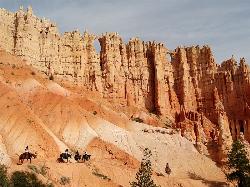
Peek-a-boo Loop
Bryce, Utah
4.8 miles S of Bryce, UtahPeek-a-boo Loop Trail is one of the more strenuous hikes available in Bryce Canyon. The unique challenge this loop provides has beautiful views that are well worth the hike. This three-mile loop can be accessed using a clearly marked trail from Bryce Point. This trail can be found on the North side of the Bryce Point parking lot.
The decent from Bryce Point to Peek-a-boo Loop Trail is rapid, making this trail more difficult than most in the park. The trail is about 2 miles, making the entire hike about 5 miles.
There are no restrooms or water stations along the trail, however the bottom of the loop is shaded with green trees, giving a wonderful respite from the heat of the sun.
From Peek-a-boo Loop Trail hikers have a wonderful view of the Bryce Amphitheater. Throughout the loop you can see several incredible rock formations, Hoodoos, both up close and in the distance.
Because Peek-a-boo Loop is a distance from any popular trailhead in Bryce it is one of the quietest hikes available, with very little traffic from other hikers. Hikers on the trail may run into mules and horses, as this is the only hiking trail open to riders. Horse and mule rides can be scheduled through Bryce Canyon Park Services.
Peek-a-boo Loop is the perfect trail for hikers looking for a challenging, quiet and scenic hike.
Riggs Spring Loop Trail
Kanab, Utah
33.5 miles NE of Kanab, UtahRiggs Spring Loop Trail is the perfect trail for hikers wishing to escape to the wilderness. This is one of the least trafficked trails in Bryce Canyon and one of the most forested. The ponderosa pines surround the Riggs Spring Loop Trail, after your decent into the canyon, making this a unique trail in the park.
The loop is a little over 8 miles in length. Because of its length and steep ascent, Riggs Spring Loop Trail is considered one of the more difficult trails in Bryce Canyon. The loop ascends and descends 2248 feet. Hikers should come prepared for a long, strenuous hike.
Riggs Spring Loop Trail begins near Rainbow Point and Yovimpa Point. Hikers connect to the loop using Bristlecone Loop Trail. This trail begins at the Rainbow Point parking lot. From Bristlecone Loop Trail hikers can find clearly marked turn offs for Riggs Spring Loop Trail. The turn offs are found about a quarter mile from the trailhead.
Though Riggs Spring Loop Trail has fewer views of the more popular Bryce Canyon rock formations, hikers experience wonderful views of the Pink Cliffs and green forests that can’t be experienced anywhere else in the park. Riggs Spring Loop Trail is a wonderful way for hikers to experience some of the park's lesser known beauties on a peaceful trail.


