


Van Buren Park Beach
Belleville
Hike and Swim
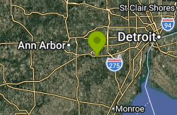
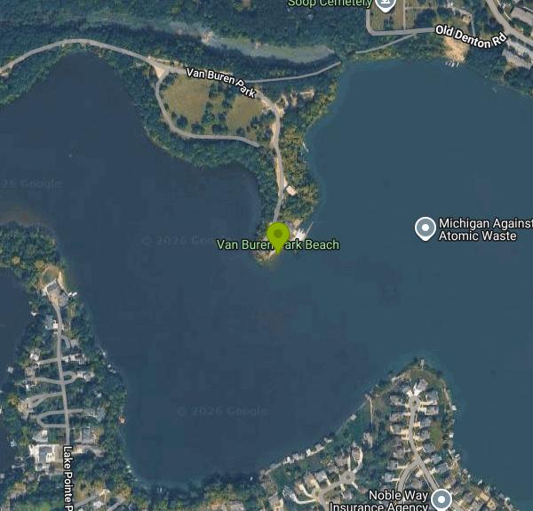
Van Buren Park Beach is the small sand beach inside Van Buren Park, a 101-acre park run by Van Buren Charter Township's Parks Department on the north shore of Belleville Lake. The lake is a 1,270-acre reservoir on the Huron River, formed in 1925 when the French Landing Dam was built, and it runs about 8 miles through the middle of the township. The beach sits at the south edge of the park facing across the water, roughly 2 miles west of downtown Belleville. Wikipedia describes it as the only public swimming area on the lake.
The park entrance is on the South I-94 Service Drive between Belleville Road and Rawsonville Road, just south of the freeway. A park road winds down to lots near the playground and restrooms, and a separate road drops down the slope to the beach. The township's 2022 to 2026 parks plan admits that this road is rough and the slope is steep, and it lists repairing the beach road, adding guardrails and stabilizing the eroding shoreline as goals. An ADA pathway to the lake was built in 2005, and accessible parking and signs were added in 2009, when the beach was also resanded.
The swim area itself is modest: a short strip of sand that park users in the township's own survey called small and hard to reach. According to township police, a walkway leads from the beach out to a sandbar where the water is roughly knee to waist deep, but the bottom drops off into deeper water if you stray from it. Belleville Lake reaches about 30 feet at its eastern end and is shallower to the west, toward the park. None of the township pages mention lifeguards, so plan on swimming unguarded and keep children within reach.
Entry is not free. The township charges a vehicle entry fee at Van Buren Park. Under the township's fee schedule a daily pass is $6 for Van Buren Township residents and $8 for everyone else, an annual pass is $18 or $24, and seniors 65 and over pay $3 or $4 a day. Active-duty service members and veterans get in free with ID. Park hours are 10 AM to dusk Monday through Friday and 8 AM to dusk on Saturday and Sunday.
Know the hazards before you go in. In August 2012 two adults drowned after wading back from the sandbar in the dark during a power outage. They were found in about 8 feet of water some 850 feet from the beach. Stay on the sandbar route, don't swim after dark and don't go far from shore. Water quality is the other issue. The township closed the beach in August 2016 after high E. coli test results and said it would stay closed until retesting cleared it, and late-summer algae blooms on Belleville Lake are tested and posted when they occur. Skip a swim for a day or two after heavy rain, and check for posted signs or call the parks office at 734-699-8921.
The rest of the park has picnic areas and three rentable pavilions, grills, a playground, a basketball court, a community garden, a sledding hill and wooded hiking trails. The University of Michigan has a boathouse at the southeast end of the park, near the beach. A township project to restore or relocate the beach is listed in the parks plan but has no firm date, so the layout may change in coming seasons.
More Information
2022-2026 Parks and Recreation
2022-2026 Parks and Recreation Master Plan
https://vbtmi.gov/community/parks%20and%20rec/VB_2022-2026-Parks-and-Recreation-Plan-ADOPTED%20FULL%20PLAN.pdfBelleville Lake drowning victims identified
Police have identified two people who drowned Saturday in Belleville Lake near Van Buren Park.
https://www.annarbor.com/news/belleville-lake-drowning-victims-identified/“ATTENTION BEACH CLOSURE AT VAN BUREN PARK UNTIL FURTHER NOTICE” from Van Buren Township Public Safe
ATTENTION BEACH CLOSURE AT VAN BUREN PARK Today August 11, 2016 The Beach at Van Buren Park is CLOSED due to high E-coli levels until the testing results show that it can be re-opened. Results ...
https://nixle.us/936T2Be courteous, informed, and prepared. Read trailhead guidelines, stay on the trail, and don't feed the wildlife.
Read More
- Plan Ahead and Prepare
- Travel & camp on durable surfaces
- Dispose of waste properly
- Leave what you find
- Minimize campfire impacts
- Respect wildlife
- Be considerate of other visitors
Directions
From Belleville
- Head east on E F St toward Lebanon Ave (328 ft)
- Turn left onto Lebanon Ave (5.2 mi)
- Continue onto S Main St (2.1 mi)
- Turn right onto E Hwy 50 (4.2 mi)
- Turn left onto S Madison St (0.6 mi)
- Continue straight onto State Rte 4 N/
N Madison St Continue to follow State Rte 4 N(10.9 mi) - Turn right to merge onto I-70 E toward Effingham (77.3 mi)
- Keep right to stay on I-70 E, follow signs for IndianapolisEntering Indiana(58.7 mi)
- Keep right to stay on I-70 E (68.2 mi)
- Take exit 69 for I-465 S/
I-74 E (3.5 mi) - Take the I-465 N/
I-74 W ramp to Peoria (0.8 mi) - Merge onto I-465 N/
I-74 Continue to follow I-465 N(25.6 mi) - Slight left (0.6 mi)
- Keep left (0.4 mi)
- Take the exit (0.3 mi)
- Slight right onto the ramp (0.1 mi)
- Slight right (1.3 mi)
- Merge onto I-69 N (signs for I-465 S) (94.9 mi)
- Take exit 296A to merge onto I-469 E/
US-33 S Continue to follow I-469 E(20.7 mi) - Take the exit onto US-24 EEntering Ohio(79.6 mi)
- Take exit 68B to merge onto I-475 N/
US-23 N toward Ann Arbor (9.3 mi) - Keep left to continue on US-23 N, follow signs for Sylvania/
Ann Arbor Entering Michigan(38.1 mi) - Take exit 35 to merge onto I-94 E (7.6 mi)
- Take exit 187 for Rawsonville Rd (0.3 mi)
- Turn right onto Rawsonville Rd (0.1 mi)
- Turn left onto S Interstate 94 Service Dr (0.5 mi)
- Turn right onto Van Buren ParkDestination will be on the left(1.2 mi)
Other Swimming Holes and Hiking Trails Nearby

Spring Mill Pond Beach
Brighton
21.6 miles NWA buoyed swim beach on small, spring-fed Spring Mill Pond inside Island Lake Recreation Area near Brighton, with cooler, clearer water than the park's river lakes. A Michigan Recreation Passport is required.
Hike, Swim
Mercer Beach
Walled Lake
22.1 miles NFree City of Walled Lake beach with about 200 feet of sand on the north shore of Walled Lake, at the edge of downtown. Buoyed swim area, no lifeguard, seasonal restrooms, playground, no pets.
Swim
Pickerel Lake
Dexter, Michigan
27.0 miles NWA spring-fed, totally undeveloped lake surrounded by conifers near Dexter — clean enough to float in, home to herons and sandhill cranes, with a small sandy beach.
Swim
Belle Isle Beach
Detroit
29.3 miles EA half mile of Detroit River sand on a state-run island park between Detroit and Windsor, with a buoyed swim area open Memorial Day through Labor Day. No lifeguards, a three mile an hour river past the buoys, and periodic E. coli closures.
Canoe, Hike, Kayak, Swim
Portage Lake Beach
Grass Lake
37.1 miles WThe day-use swimming beach on Big Portage Lake in Waterloo Recreation Area, Michigan's largest Lower Peninsula state park. A state Recreation Passport is required for vehicles.
Camp, Canoe, Hike, Kayak, Swim
Maumee Bay State Park Beach
Oregon
37.2 miles STwo free sand beaches in one Ohio state park east of Toledo: an open Lake Erie shore on Maumee Bay, and a sheltered 57-acre inland lake a short walk behind it, with marsh boardwalk and 300-plus bird species beyond.
Camp, Canoe, Hike, Kayak, Swim
Baypoint Beach
Rochester
41.9 miles NEUnguarded sand swimming beach on the west shore of Stony Creek Lake in Stony Creek Metropark, a quieter alternative to Eastwood Beach. Open May 1 to October 1, 8 a.m. to 8 p.m., with a $10 daily vehicle pass.
Canoe, Hike, Kayak, Swim
Linden County Park
Linden
42.8 miles NClover Beach at Genesee County's Linden County Park is a free, unguarded swim beach on Byram Lake just south of Linden, open 8 a.m. to 8 p.m. daily from Memorial Day weekend through Labor Day.
Hike, SwimNearby Campsites
Portage Lake Beach
Grass Lake
37.1 miles WThe day-use swimming beach on Big Portage Lake in Waterloo Recreation Area, Michigan's largest Lower Peninsula state park. A state Recreation Passport is required for vehicles.
Camp, Canoe, Hike, Kayak, Swim
Maumee Bay State Park Beach
Oregon
37.2 miles STwo free sand beaches in one Ohio state park east of Toledo: an open Lake Erie shore on Maumee Bay, and a sheltered 57-acre inland lake a short walk behind it, with marsh boardwalk and 300-plus bird species beyond.
Camp, Canoe, Hike, Kayak, Swim


