


Bear Creek Lake State Park Beach
Cumberland, Virginia

| GPS: |
37°31'43.1"N 78°16'16.5"W Maps | Directions |
| State: | Virginia |
Camp, Hike, Kayak, Mountain Bike, and Swim
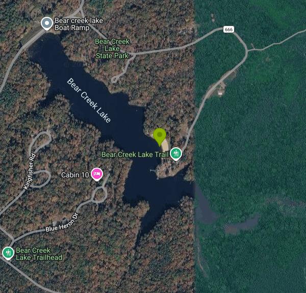
Bear Creek Lake is a small park with a lot packed into it. The 329-acre state park sits in the middle of the 16,000-acre Cumberland State Forest in central Virginia, an hour west of Richmond, and its centerpiece is a 40-acre lake with a sand beach on the south shore. The beach has a roped swim area, a bathhouse and a snack bar, and it is open from Memorial Day weekend through Labor Day. No lifeguard is on duty. Parking is a per-vehicle state park fee at the contact station, which is the only charge to swim. The address is 22 Bear Creek Lake Road, off VA 629 north of the town of Cumberland.
The lake is electric-motor only, and the boathouse next to the beach rents canoes, kayaks, paddleboards and jon boats, so a lazy loop of the shoreline is easy to add to a beach day. Fishing is good for largemouth bass, bluegill and channel catfish, and there is a fishing pier and a boat ramp for cartop and small trailered boats. The lake is fed by Bear Creek and sits low in a bowl of hardwoods, so the water is calm and the beach gets shade by late afternoon, which is when the day-use crowd thins and the swim is best.
Trails are the park's other draw. Inside the park boundary there are about eight miles for hikers, and two longer routes leave from the park: the 15.7-mile Cumberland Multi-use Trail, a loop through the state forest open to mountain bikes and horses, and the 16-mile Willis River Trail, a point-to-point hiking route that follows the Willis River through the forest. Riders and hikers park at the trailhead lot near the entrance. The forest roads that lace the state forest are open to bikes as well, and in fall the hunting seasons make blaze orange a good idea on anything outside the park boundary. A 10-lane archery range near the beach is free to use with your own gear, and the park runs a summer schedule of ranger programs, night hikes and canoe tours from the boathouse.
The campground has 45 sites in three loops named Acorn, Black Oak and Chestnut, with water and electric hookups on most and a bathhouse in each loop, open March through early December. Cabins and a 16-person lodge sit on the wooded hillside above the lake and are booked most summer weekends months out. The park began in 1940 as a wayside inside the state forest, one of the first recreation areas Virginia's forestry agency opened to the public, and it did not become a state park until decades later. Cumberland is a farm-and-forest county without much traffic, so the park stays uncrowded on weekdays even in July.
More Information
Never modify trail features. Ride trails when they're dry enough that you won't leave ruts. Speak up when you see others on the trail and always yield to hikers, horses, and others coming uphill. Always ride on the established trail.
Read MoreBe courteous, informed, and prepared. Read trailhead guidelines, stay on the trail, and don't feed the wildlife.
Read More
- Plan Ahead and Prepare
- Travel & camp on durable surfaces
- Dispose of waste properly
- Leave what you find
- Minimize campfire impacts
- Respect wildlife
- Be considerate of other visitors
Directions
From Cumberland, Virginia
- Head east toward Trents Mill RdRestricted usage road(0.1 mi)
- Turn left onto Trents Mill Rd (2.3 mi)
- Turn left onto Oak Hill Rd (0.8 mi)
- Turn left toward Bear Creek Lake Rd (164 ft)
- Turn left onto Bear Creek Lake Rd (0.7 mi)
 The swimming beach at Bear Creek Lake State Park courtesy of Virginia State Parks↗ (CC BY 2.0↗)

 Bear Creek Lake beach and swim area courtesy of Virginia State Parks staff↗ (CC BY 2.0↗)

 Path down to the beach courtesy of Virginia State Parks↗ (CC BY 2.0↗)

 Picnic table above the swim beach courtesy of Virginia State Parks↗ (CC BY 2.0↗)

 Canoes and boats for rent at the boathouse courtesy of Virginia State Parks staff↗ (CC BY 2.0↗)
 The campground at Bear Creek Lake State Park courtesy of Virginia State Parks↗ (CC BY 2.0↗)
 Bear Creek Lake in April courtesy of Crazyblocks↗ (CC0↗)

Other Mountain Bike Trails, Swimming Holes, Hiking Trails, and Kayaking Areas Nearby
Nottoway Falls
Crewe, Virginia
34.0 miles SNottoway Falls' wide cascade offers generous swimming space at the base, with parking discreetly available near the boat ramp — water can run low in summer.
Swim 
Riverside Drive Area
Grottoes, Virginia
39.8 miles ESwim near Grottoes, Virginia
Swim 
Pauls Creek
Nellysford, Virginia
42.3 miles NWA quick 1.2-mile hike along Paul's Creek leads to a cascading waterfall and a natural water slide — stones smoothed by the water let visitors slide right into the swimming hole below.
Hike, Swim 
Charlottesville Area
Williamsville, Virginia
45.0 miles NTwo swimming spots north of Charlottesville, Virginia — a fee applies, so check details before heading out.
Swim 
Richmond Downtown Area
Purcellville, Virginia
45.4 miles ESwim near Purcellville, Virginia
Swim 
Mint Springs Valley Park
Crozet, Virginia
45.7 miles NWTwo small lakes with sandy beaches, miles of forested hiking and mountain biking trails, a sand volleyball pit, and a playground — all in an eight-acre valley park near Crozet, Virginia.
Hike, Mountain Bike, Swim 
Campbell Creek
Tyro, Virginia
46.5 miles NWA 6-mile Appalachian Trail stretch with good elevation rewards remote explorers with a creek pool at the base of a waterfall — optional swimwear in this backcountry spot.
Swim 15.7 mi
Sugar Hollow
Crozet, Virginia
49.7 miles NWAn 11-mile loop starting and ending at Sugar Hollow Reservoir, passing Blue Hole and Rip Rap swimming holes — a hiker's way to combine challenge with a cool dip in Shenandoah.
Hike, Swim


