


East Rosebud Lake
Roscoe, Montana

| Address: | Lake Rd, Roscoe, MT 59071, USA |
| GPS: |
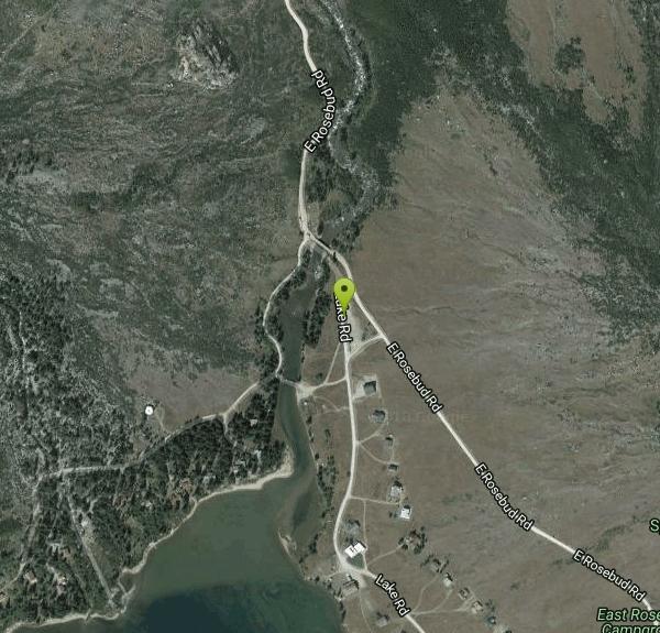
45°12'13.1"N 109°38'28.6"W Maps | Directions |
| State: | Montana |
| Trails/Routes: | 25.6 mi |
Lakes Rivers Waterfalls Streams Trails
Backpack, Camp, Canoe, and Hike
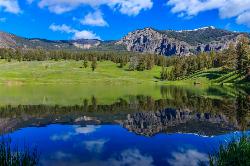
Ringed by soaring granite walls at the mouth of a classic glacial canyon, East Rosebud Lake is one of the most beautiful road-accessible spots in Montana's Absaroka-Beartooth country — and the gateway to what many consider the single finest backpacking trip in the Northern Rockies. A cluster of rustic cabins lines the north shore, forming a quiet, historic alpine hamlet at the very end of East Rosebud Road (Forest Road 2177), reached by driving 10 to 11 miles up a gravel road from the tiny town of Roscoe, southwest of Red Lodge.
The lake itself is a stunner — cold, clear water backed by cliffs, forest, and tumbling waterfalls, with East Rosebud Creek pouring in at its head. In 2018 that creek earned a rare federal Wild and Scenic designation, protecting it free-flowing for good. But for many visitors, it's the trailhead at the south end that draws them: the start of the East Rosebud Trail (#15), universally known as “The Beaten Path.”
This roughly 26-mile point-to-point traverse threads the very heart of the Absaroka-Beartooth Wilderness to the Clarks Fork Trailhead near Cooke City and Yellowstone's northeast corner. Climbing steadily some 4,000 feet to its high point near Fossil Lake on the Beartooth Plateau, it strings together an almost unbelievable procession of alpine lakes — Elk (about 3.5 miles in), Rimrock, Rainbow (8 miles), Lake at Falls, Big Park, Duggan, Twin Outlets, and Dewey — along with the magnificent Impasse Falls, where the creek plunges some 150 feet into little Duggan Lake. Most parties take three to five days, camping lakeside and fishing the cutthroat- and trout-filled waters along the way.
You don't have to thru-hike it to fall for the place, though. Day hikers commonly follow the lower trail to Elk Lake or the first waterfalls and turn around, soaking in wilderness scenery on an easy, family-friendly out-and-back. Anglers work the lake and creek, and the whole valley is a photographer's dream in the low light of morning and evening.
The lakeside East Rosebud Campground (Custer Gallatin National Forest) makes an ideal basecamp, typically open from late May into early September and often full on summer weekends. Note that much of the shoreline and the cabins are private property, so respect posted areas; direct lake access and boating are limited, and the real prize here is the scenery and the trail rather than a public beach.
This is high, wild, grizzly country. Carry bear spray and know how to use it, store all food properly, and be ready for sudden mountain weather — snow and freezing temperatures are possible even in midsummer at the higher lakes. Thru-hikers should arrange a car shuttle between the East Rosebud and Clarks Fork trailheads, which are a long, roundabout drive apart, and be prepared for stream crossings, lingering early-season snowfields on the high plateau, thick mosquitoes in July, and genuine remoteness far from help. The prime window is mid-July through September; earlier and you'll be wading snow up high, later and the first storms of autumn can shut the pass. However you experience it — a lakeside picnic or a five-day traverse — East Rosebud is Montana at its most magnificent.
More Information
Custer Gallatin National Forest : Trail - East Rosebud Trail (# 15)
East Rosebud Trail (# 15) is 16 miles long. The East Rosebud Trail is also known as “The Beaten Path”.
https://www.fs.usda.gov/r01/custergallatin/recreation/trails/east-rosebud-trail-15The Beaten Path Hiking Trail, Red Lodge, Montana
An epic traverse of the Beartooth Range from East Rosebud to Cooke City. Near Red Lodge, Montana.
https://www.hikingproject.com/trail/7004180/the-beaten-pathBe courteous, informed, and prepared. Read trailhead guidelines, stay on the trail, and don't feed the wildlife.
Read More- Plan Ahead and Prepare
- Travel & camp on durable surfaces
- Dispose of waste properly
- Leave what you find
- Minimize campfire impacts
- Respect wildlife
- Be considerate of other visitors
Directions
From Roscoe, Montana
- Head south toward E Rosebud Rd (82 ft)
- Turn right onto E Rosebud Rd (2.2 mi)
- Turn left to stay on E Rosebud Rd (1.5 mi)
- Turn right to stay on E Rosebud Rd (10.0 mi)
- Slight right onto Lake Rd (223 ft)

Other Hiking Trails, Canoeing Areas, and Backpacking Trails Nearby
Trout Lake and Buck Lake
Tower Junction, Yellowstone National Park
31.6 miles SWA steep half-mile through Douglas fir forest opens to beautiful views every direction — Mount Hornaday behind the lake, spring waterfalls from snowmelt, and cutthroat trout thick enough to give the lake its name.
Hike 8.5 mi
Slough Creek Trail
Tower Junction, Yellowstone National Park
37.2 miles SWAn easy 3.4-mile historic wagon trail follows Slough Creek through sweeping meadows in Yellowstone — a peaceful summer and fall walk with beautiful open views.
Hike 4.0 mi
Specimen Ridge Day Hike and Fossil Forrest Trail
Buffalo Ford, Wyoming
39.2 miles SWA strenuous 4-mile hike to Specimen Ridge with rewarding views, plus a side route to an outcropping of fossilized trees visible from the ridge — rugged and unmarked, but worth it.
Hike 16.9 mi
Specimen Ridge Trail (2K4)
Buffalo Ford, Wyoming
41.7 miles SWA challenging 17-mile remote hike ascending 3,000 feet to Amethyst Mountain and descending into Lamar Valley — ending at a river ford that may require turning around if uncrossable.
Hike 7.3 mi
Agate Creek Trail
Tower Junction, Wyoming
42.1 miles SWA moderately difficult 7.3-mile hike along Yellowstone River with colorful cliff overlooks, the Narrows, and a primitive riverside campground at trail's end.
Hike 0.3 mi
Yellowstone River Picnic Area Trail
Tower Junction, Yellowstone National Park
42.1 miles SWA 3.9-mile loop trail from a Yellowstone picnic area along the canyon rim of the Yellowstone River — steam vents, wildlife sightings in meadows, and canyon erosion views throughout.
Hike
Tower Falls
Tower Junction, Yellowstone National Park
42.4 miles SWTower Fall plunges 132 feet off Tower Creek in Yellowstone, framed by dramatic rock pinnacles — located about 3 miles south of Roosevelt Junction.
Camp, Hike
Hellroaring Creek Trail
Yellowstone National Park
42.6 miles SWA suspension bridge over the Yellowstone River leads to sandy creek-side beaches and a mild backcountry trail past Yellowstone's largest granite slab — great for all ages.
Camp, Hike, Swim 8.2 mi
Garnet Hill Trail
Tower Junction, Yellowstone National Park
42.7 miles SWA 7.6-mile loop through Yellowstone meadows, sagebrush, and riverside forest with exceptional wildlife — wolves, bears, bison, moose, elk, and badgers all roam this area.
Hike 2.4 mi
Lost Lake Trail
Tower Junction, Yellowstone National Park
43.1 miles SWAn easy 2.8-mile loop behind Roosevelt Lodge, winding through forest, meadows, and along the shores of Lost Lake — open year-round and finishable in under two hours.
Hike 4.4 mi
Chittenden Road - Mount Washburn Trail
Canyon Village, Yellowstone National Park
47.9 miles SWA steady, well-packed 5.8-mile out-and-back on the former Chittenden service road to Mount Washburn's summit, with bighorn sheep, wildflowers, and sweeping Yellowstone views at the top.
Hike 16.3 mi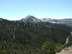
Mount Washburn Spur Trail
Canyon Village, Yellowstone National Park
48.0 miles SWAn 8-mile descent from the peak of Mount Washburn through bighorn sheep country, wildflower meadows, and forests to Canyon Village — with sweeping Grand Canyon of Yellowstone views from the top.
Hike
Forces of the Northern Range
Mammoth, Yellowstone National Park
48.3 miles WA half-mile boardwalk on Yellowstone's Blacktail Deer Plateau with mountain peak displays, a wildlife primer, and a view-packed introduction to the Northern Range's forces of nature.
Hike 3.4 mi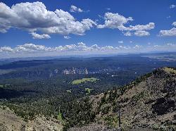
Dunraven Pass - Mount Washburn Trail
Canyon Village, Yellowstone National Park
49.2 miles SWA 6-mile Yellowstone hike via Dunraven Pass through quiet forests to the summit of Mount Washburn — a panoramic perch with bighorn sheep in summer and grizzlies near pine nuts in fall.
Hike 7.4 mi
Blacktail Deer Creek to Yellowstone River Trail
Mammoth Hot Springs, Yellowstone National Park
49.6 miles WA 7-mile out-and-back trail dropping through green fields and boulder formations to waterfall views along the Yellowstone River, with a suspension bridge connecting onward trails.
HikeNearby Campsites

Pebble Creek Campground
Northeast Entrance, Yellowstone National Park
30.4 miles SWA quiet campground tucked in Yellowstone's far northeast corner near Trout Lake and world-class Lamar and Soda Butte trout rivers — arrive before 11 a.m. to secure a spot.
Camp
Slough Creek Campground
Tower Junction, Yellowstone National Park
37.0 miles SWA small, popular Yellowstone campground right on Slough Creek where wolf packs are frequently spotted — sites fill fast, so arrive early.
Camp
Tower Falls
Tower Junction, Yellowstone National Park
42.4 miles SWTower Fall plunges 132 feet off Tower Creek in Yellowstone, framed by dramatic rock pinnacles — located about 3 miles south of Roosevelt Junction.
Camp, Hike
Hellroaring Creek Trail
Yellowstone National Park
42.6 miles SWA suspension bridge over the Yellowstone River leads to sandy creek-side beaches and a mild backcountry trail past Yellowstone's largest granite slab — great for all ages.
Camp, Hike, Swim


