


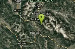
40 Hiking Trails near Blue Miner Lake
first prev 1 2 next lastShowing Hiking Trails within 50 miles Distance miles of Forest Rd 30377, Kelly, WY 83011, USA City, Zip, or Address
Cache Creek Trial
Jackson, Wyoming
11.2 miles SWA groomed cross-country ski trail with an 850-foot elevation gain and loss near Jackson, Wyoming — snowmobiles are allowed and grooming runs Monday, Wednesday, and Friday mornings out 4.6 miles.
Hike
Jumping Rock at Phelp's Lake
Jackson, Wyoming
13.6 miles WA solo 20-foot boulder perched above deep water at Phelps Lake, with Death Canyon looming overhead — one of the most dramatic jump spots in all of Wyoming.
Dive, Hike, Swim 1.3-4.3 mi
Phelps Lake
Jackson, Wyoming
13.7 miles WA 5.5-mile loop around beautiful Phelps Lake with mountain scenery, majestic blue water, several Teton waterfalls, and lakeside campsites — plus a popular cliff jumping rock along the trail.
Backpack, Camp, Dive, Hike, Swim 3.9-14.4 mi
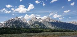
Grand Teton
Jackson Hole, Wyoming
16.5 miles NWAt 13,770 feet, the Grand Teton towers over Western Wyoming — all popular routes require rock climbing gear and are for skilled climbers only, with 3,000 feet of exposure where a fall is fatal.
Backpack, Hike, Rock Climb 13.8 mi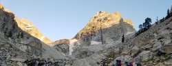
Middle Teton
Jackson Hole, Wyoming
16.5 miles NWThe 12,804-ft Middle Teton rewards serious alpinists with glacier bouldering through the Southwest Couloir and panoramic views of the Grand, South, and surrounding Tetons.
Backpack, Hike, Rock Climb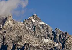
Mount Owen
Jackson, Wyoming
16.5 miles NWHike near Jackson, Wyoming
Hike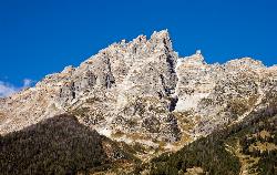
Teewinot Mountain
Jackson Hole, Wyoming
16.5 miles NWBackpack and Hike near Jackson Hole, Wyoming
Backpack, Hike 24.3 mi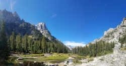
Cascade Canyon Trail
Jackson Hole, Wyoming
16.8 miles NWA wildlife-rich canyon hike past Hidden Falls and into Cascade Canyon, where waterfalls pour off glacier-fed mountains flanking the Grand Teton.
Backpack, Hike 4.9 mi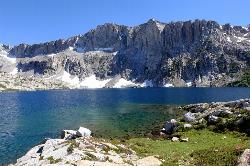
Amphitheater Lake
Alta, Wyoming
17.7 miles NWBackpack and Hike near Alta, Wyoming
Backpack, Hike 1.0-5.1 mi
Jenny Lake Trail
Jackson Hole, Wyoming
18.4 miles NWAn easy loop around Jenny Lake in Grand Teton National Park — visiting Hidden Falls, Inspiration Point, and abundant wildlife including marmots, moose, and occasional bears along the well-built stone-stair trail.
Hike 10.5-16.2 mi
Paintbrush Canyon
Alta, Wyoming
18.8 miles NWA beautiful trail along String Lake, Leigh Lake, and Lake Solitude in Grand Teton — with a short, rewarding scramble to the secluded Micah Lake perch for even fewer crowds.
Backpack, Hike 3.6 mi
String Lake
Alta, Wyoming
18.9 miles NWA shallow, warm lake connecting Jenny and Leigh Lakes at the base of the Tetons — the clear water lets you see the bottom from a kayak, wade easily with kids, and access wilder open water beyond.
Canoe, Hike, Kayak, Swim 0.1-7.3 mi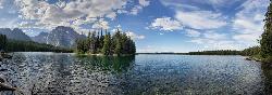
Leigh Lake
Alta, Wyoming
19.1 miles NWTucked beneath Mount Moran and just a mile from the String Lake trailhead, Leigh Lake rewards with majestic serenity, shoreline views of Boulder Island, and calm waters perfect for kayaking or canoeing.
Backpack, Canoe, Hike, Kayak
Mt. Moran
Alta, Wyoming
23.0 miles NWAt 12,610 feet, this dominant Teton peak rises 6,000 feet above Jackson Lake, with the Skillet Glacier plainly visible on its massive east face.
Hike 4.6 mi
Coal Creek Trail
Alta, Wyoming
23.8 miles WA hike beyond Coal Creek Meadows to a mountain divide with dramatic views of the Mesquite Creek Valley and the peaks to the north, including Grand Teton on the horizon.
Hike, Mountain Bike 7.9 mi
Devil's Stairs
Driggs, Idaho
24.1 miles NWAn 8-mile round-trip trail that starts from the Teton Canyon Trailhead, climbs 1,000 feet in switchbacks, and arrives at a stunning high meadow filled with wildflowers and framed by a towering cliff.
Backpack, Hike 15.0-18.4 mi
Alaska Basin
Driggs, Idaho
24.1 miles NWA stunning trail through the Jedediah Wilderness into Wyoming near Grand Teton National Park, with wildflowers, rushing rivers, the Teton Range, and the serene Alaska Basin — intermediate to advanced.
Backpack, Hike, Horseback 3.8-6.4 mi
Table Rock / Table Mountain
Driggs, Idaho
24.2 miles NWA big climb to 11,300 feet for arguably the finest view of the Grand Tetons — pick the steep Face or the gradual Huckleberry trail.
Camp, Hike 6.2 mi
Darby Wind Cave
Driggs, Idaho
24.2 miles WWaterfalls, wildflowers, creek crossings, and a wind cave high on the canyon wall — Darby's switchback trail rewards hikers with views found nowhere else in the Tetons.
Backpack, Cave, Hike, Rock Climb 4.5 mi
Sheep Bridge Trail
Driggs, Idaho
27.3 miles NWAn easy 2.25-mile trail through summer wildflowers and kaleidoscopes of butterflies along Teton Creek — cross a bridge, meander east, and dip down to the creek at a midway rest spot.
Hike, Mountain Bike


