


6 Hiking Trails near Greenbelt Plateau
first prev 1 next lastShowing Hiking Trails within 50 miles Distance miles of Hwy 93 & Hwy 128, Colorado 80303, USA City, Zip, or Address

Mallory Cave
Boulder, Colorado
4.3 miles NWThis hike starts at the NCAR parking lot. Head west to the Mesa trail and cross it by the information sign. There are lots of offshoot trails, be sure to follow the signs to the final 100 ft rock...
Cave, Hike 0.1-0.9 miClear Creek Whitewater Park
Golden, Colorado
12.0 miles SDedicated in 1998 and located in Golden, Colorado, Clear Creek Park is one of the most unique parks in Colorado filled with water activities such as kayaking and canoeing. It reaches a quarter...
Canoe, Hike, Kayak, Mountain Bike, Swim, Whitewater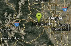
Braille Trail / Beaver Brook Trail
Golden, Colorado
15.3 miles SBeaver Brook Trail is actually a small system of trails that sit very close to the front range of the Denver Metro area. A few small loops can be done, but for the most part most people will do this...
Hike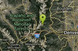
Saint Mary's Glacier
Idaho Springs, Colorado
22.9 miles WSaint Mary's Glacier (or Saint Marys) is a semi-permanent snowfield located in Arapaho National Forest in the U.S. state of Colorado. Saint Mary's Glacier is 2.5 mi (4.0 km) southeast of...
Hike
Herman Gulch
Silver Plume, Colorado
36.5 miles SWHerman Gulch is a well traveled trail, right off of I-70. It gets busy quickly. This trail is about a 6 mile out and back trail that starts with a sharp incline and runs along a river. This hike is...
Backpack, Hike
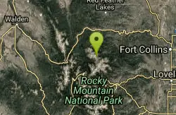
Emmaline Lake
Bellvue, Colorado
47.9 miles NWEmmaline Lake is one of those scenic alpine jewels that make hiking in Colorado so enjoyable. It is set in a deep mountain cirque on the northern side of the Mummy Range. The lake lies 1,700 feet...
Hike


