


136 Hiking Trails near Holbert Trail to Dobbins Lookout
first prev 1 2 3 4 5 6 7 next lastShowing Hiking Trails within 50 miles Distance miles of Phoenix S Mountain Park, Phoenix, AZ 85042, USA City, Zip, or Address
Ruth Hamilton Trail
Phoenix, Arizona
13.8 miles NHike and Mountain Bike near Phoenix, Arizona
Hike, Mountain Bike 8.3 mi
Estrella Mountains Competitive Track
Tolleson, Arizona
14.1 miles WThe third competitive track in the Maricopa County Regional Park system, located in Estrella Mountain Regional Park, was completed in February 2000. The track consists of two loops totaling 13 miles....
Hike, Horseback, Mountain Bike
Quartz Peak Trail
14.4 miles SW
Hike near
Hike 1.3 mi
Dreamy Draw Loop Trail
Phoenix, Arizona
14.9 miles NThe Dreamy Draw Nature Trail is a short multi-access loop trail that provides a true Sonoran Desert experience. The trail crosses a number of desert washes and, at times, becomes somewhat rocky....
Hike, Horseback, Mountain Bike
L.V. Yates to "Two Bit" Peak Loop
Phoenix, Arizona
15.5 miles NWell this time of the year there really was not a lot of wild life to see, just to hot. Starting from the 40st trailhead gave me a different view of the preserve. I really enjoyed...
Hike, Horseback 2.6 mi
L.V. Yates Trail (#8)
Phoenix, Arizona
15.5 miles NThe trail is strewn with large rocks and gulleys from recent torrential rains. Not impassable on foot, but definitely some hike-a-bike areas. Keep in mind there's no ridge hiking...
Hike, Horseback, Mountain Bike 3.6 mi
Charles M. Christiansen Memorial Trail
Phoenix, Arizona
15.6 miles NPhoenix, Arizona is home to some of the best and largest city parks in the country and the Charles M. Christiansen Memorial Trail is a great introduction to this fantastic park system. Also known as...
Hike, Horseback, Mountain Bike 7.1 mi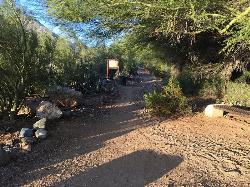
Trail 100
Phoenix, Arizona
15.6 miles NMountain Bikers and Hikers in Phoenix, Arizona can rejoice in the challenge that is Trail 100. Trail 100, or Charles M. Christensen Memorial Trail, is a little over 14 miles out and back in the...
Hike, Mountain Bike

Maxine Lakin Nature Trail
Phoenix, Arizona
15.7 miles NHike near Phoenix, Arizona
Hike
North Mountain National Trail
Phoenix, Arizona
16.4 miles NNorth Mountain National Trail is a 2.3 mile moderate, loop trail near Phoenix. It's easy to travel on if you go up the paved sections. The inclines are steep in parts, making it a real...
Hike
Shaw Butte and Charles M Christiansen Loop Trail
Phoenix, Arizona
17.0 miles NWhen you say "North Mountain," I think most Arizonans know where it is or can find it. When you say "Shaw Butte," it seems like you get a lot more questioning glances and "huh?". Shaw...
Hike, Mountain Bike 2.9 mi
Coldwater Trail
Goodyear, Arizona
17.3 miles WThe Cold Water Trail #27 is a seldom visited, remote backcountry destination along the backdrop of the rugged Verde Rim with healthy mixed vegetation and unique geology. The trail was originally used...
Hike, Horseback, Mountain Bike 13.8 mi
Butterfield to Gadsen Loop Trail
Goodyear, Arizona
17.3 miles WAs with other trails in Estrella, the trail is wide and the surface tends to be rather benign, varying from mostly smooth, to occasionally strewn with small rocks, sandy in the washes. Butterfield...
Hike, Horseback, Mountain Bike
Baseline Trail
Goodyear, Arizona
17.4 miles WThe Baseline trail is a 2.6 mile loop at Estrella Mountain Regional Park. This listing is based on access from a spur trail (33.378981, -112.371072) off of the Gila trail. Access is...
Hike 3.6 mi
Toothaker Trail
Goodyear, Arizona
17.5 miles WToothaker is an easy roller coaster of a trail. It crosses numerous washes ranging from small to large and can be a tad loose and/or rocky in some sections. The end reward is a nice view of Rainbow...
Hike, Horseback, Mountain Bike
Dysart Trail
Goodyear, Arizona
17.5 miles W$6 entry fee per car.
Hike, Horseback, Mountain Bike
Rainbow Valley to Toothaker Loop Trail
Goodyear, Arizona
17.5 miles WEstrella Mountain Regional Park has many trails within it, a great beginner to intermediate friendly trail is the Rainbow Valley to Toothaker Loop Trail. This 6.6 mile hike is mostly flat with a few...
Hike, Horseback, Mountain Bike 1.0 mi
Quail Trail
Goodyear, Arizona
18.0 miles WQuail Trail is the access trail from the Nature Center to the main trail system. It is a pretty steep climb, but smooth and steady. Quail Trail is a spur trail in the Estrella Mountain...
Hike, Horseback, Mountain Bike
Shadow Mountain Trail
Phoenix, Arizona
18.6 miles NThis particular route trailhead starts at 23rd place and Sweetwater rd it's a great wildlife trail.
Hike
Lookout Mountain Circumference Trail
Phoenix, Arizona
19.0 miles NHike near Phoenix, Arizona
Hike


