


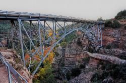
84 Hiking Trails near Verde Hot Springs
first prev 1 2 3 4 5 next lastShowing Hiking Trails within 50 miles Distance miles of Child's Power Rd, Arizona, USA City, Zip, or Address
Huckaby Trail
Sedona, Arizona
36.0 miles NOn the hunt for adventure? Established in 1998, Huckaby Trail is just the adventuresome route for both avid hikers and mountain bikers. It offers up forestry of Arizona Sycamores and picturesque...
Canoe, Hike, Mountain Bike 0.8 mi
Promontory Butte
Payson, Arizona
36.2 miles EThis destination is on the edge of Promontory Butte, providing spectacularly scenic views as part of the Mogollon Rim. There are several old forest roads on the mountain that can serve as trails to...
Hike 8.5 mi
Munds Wagon Trail
Sedona, Arizona
36.4 miles NMunds Wagon Trail is different from many of the other more “classic†rides around Sedona. If you come from somewhere else and are missing the feel of loose rocks...
Hike, Mountain Bike 0.8 mi
Christopher Creek Gorge
Payson, Arizona
36.7 miles EChristopher Creek Gorge is a fun swimming or canyoneering destination located in Christopher Creek, just outside of Payson, Arizona. To get there, you have to hike from the Christopher...
Canyoneer, Hike, Swim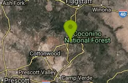
Midgley Bridge Trail
Sedona, Arizona
37.2 miles NHike near Sedona, Arizona
Hike
Wilson Mountain Trail
Sedona, Arizona
37.3 miles NHike near Sedona, Arizona
Hike 3.4 mi
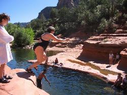
Grasshopper Point
Sedona, Arizona
37.4 miles NGrasshopper Point is a beautiful swimming hole located in Sedona, Arizona. Grasshopper Point is the perfect place to cool off in the summer after a nice hike, or a hot summer day. This swimming...
Dive, Hike, Swim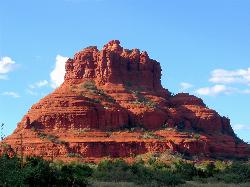
Schnebly Hill Vista Overlook
Sedona, Arizona
37.4 miles NThe Schnebly Hill Formation is a beautiful red rock gem in Sedona, Arizona. This rock formation is considerably big, which is why it is divided into four different sections that are called...
Hike 1.1 mi
Christopher Creek Campground
Payson, Arizona
37.7 miles EChristopher Creek is a popular campground situated just east of Payson, nestled between the Christopher Creek river, and the town of the same name. This site is used for both overnight and day-use...
Camp, Canyoneer, Cross-country Ski, Hike, Swim
Devil's Bridge
Sedona, Arizona
38.8 miles NWe loved the red rock views on this hike! It's a 3.6 mile round-trip trail, on rocky/sandy ground, and is fairly easy, until the last mile, which is steep. Dozens of jeeps and ATVs passed us -...
Hike 3.3 mi
See Canyon Trail
Payson, Arizona
39.0 miles ESee Canyon Trail #184 takes the hiker on a journey through the wooded Arizona wilderness surrounding Christopher Creek, and leading up the Mogollon Rim. This trail has trailhead markers at the...
Hike 5.8 mi
Go John Trail
Cave Creek, Arizona
39.7 miles SWThe Go John Trail is a 5.8 mile loop trail outside of Cave Creek, Arizona, that is moderately trafficked, used by both hikers and mountain bikers. It is an excellent opportunity to view the desert...
Hike, Horseback, Mountain Bike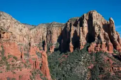
Brins Mesa Trail
Sedona, Arizona
39.8 miles NBrins Mesa Trail is located in the Coconino National Forest just at the edge of the town of Sedona. This trail will provide picturesque views of the gorgeous, geological landscape. Brins...
Hike
Clay Mine Trail
Cave Creek, Arizona
40.4 miles SWClay Mine Trail is a 1.6 mile out-and-back, beginner friendly trail in Cave Creek Regional Park. This is a trail that is very close to the Visitor Center. It's not too difficult but there...
Hike 0.3 mi
Slide Rock
Sedona, Arizona
41.3 miles NSlide Rock is one of the most popular locations in the Sedona area. Slide Rock is natures most thrilling water slides. Slide Rock is a gargantuan 80 feet long, and 2-4 feet wide. This slippery slope...
Hike, Swim
Brown Ranch Trail to Cone Mountain Trail
Scottsdale, Arizona
41.3 miles SHike near Scottsdale, Arizona
Hike
Jane Rau Brown's Canyon Trail
Scottsdale, Arizona
41.4 miles SThe Jane Rau Brown Canyon Trail was named after Jane Rau Brown, one of the pioneers of the McDowell Sonoran Conservancy, for her determination and passion in preserving the desert and the park....
Hike, Horseback, Mountain Bike
Pima and Dynamite Trail
Scottsdale, Arizona
41.4 miles SPima and Dynamite is an area with a network of trails for hiking, but more popularly for mountain biking, in North Scottsdale, Arizona. The area feautures a variety of trails for...
Hike, Mountain Bike 1.4 mi
Ballantine Trail
Rio Verde, Arizona
42.0 miles Sthis trail looks a lot better once it moves away from the highway. A somewhat strenuous climb reveals a landscape of knuckle-and-joint, mica-imbedded boulders, deep gorges and a battalion of regal...
Hike 4.6 mi
Gordon Creek Falls
Payson, Arizona
42.8 miles EGordon Creek Falls is a relatively unknown little oasis in the middle of the Arizona desert--specifically, outside of the city of Payson. The falls come from Gordon Creek, which winds its way through...
Hike, Swim


