


Rip Rap Hollow
Crozet, Virginia

| Address: | Riprap Trail Parking |
| GPS: |
38°10'39.4"N 78°45'54.6"W Maps | Directions |
| State: | Virginia |
| Trails/Routes: | 6.1 mi |
Hike and Swim
Rip Rap Hollow is a secluded swimming hole that makes for a great stop along the 10 mile loop hike in Shenandoah Valley. This is a difficult hike, but for those up to the challenge it provides incredible panoramic views of the Shenandoah Valley. Along this hike hikers can also enjoy a waterfall view and views of the famous Chimney Rock.
Hikers should park in the Rip Rap Hollow Parking lot and start the loop on Appalachian Trail. For hikers who want to take the ten mile hike over a couple of days, camping is allowed in a couple of primitive camping spots along the trail. These campsites have no amenities and should be kept in their natural state by campers.
The Rip Rap Hollow swimming hole is a section of river that slows and widens into a 50 foot swimming hole. This mountain fed spring is cold and clear and makes for a beautiful spot to cool off after a long hike.
Bathing suits: May be optional depending on solitude or crowd
More Information
Riprap Trail
This 9.8 mile circuit hike offers all the best of Shenandoah – panoramic views, bubbling streams, a swimming hole and even a nice final stretch along the Appalachian Trail. It comes close t…
https://virginiatrailguide.com/2010/05/28/riprap-trail/swimmingholes.org VIRGINIA Swimming Holes and Hot Springs rivers creek springs falls hiking camping
THE web site for beautiful, natural places for a cool dip or hot soak.
https://www.swimmingholes.org/va.htmlVerifying Your Browser
Please wait while we secure your session.
https://myhikes.org/trails/riprap-hollow-hikeBe courteous, informed, and prepared. Read trailhead guidelines, stay on the trail, and don't feed the wildlife.
Read More- Plan Ahead and Prepare
- Travel & camp on durable surfaces
- Dispose of waste properly
- Leave what you find
- Minimize campfire impacts
- Respect wildlife
- Be considerate of other visitors
Directions
From Crozet, Virginia
- Head southwest on VA-240 W/
Crozet Ave toward The Square (1.4 mi) - Turn right onto US-250 W (1.4 mi)
- Merge onto I-64 W via the ramp to Staunton (7.6 mi)
- Exit onto US-250 E (0.6 mi)
- Sharp left toward Skyline Dr (495 ft)
- Turn right onto Skyline DrParts of this road may be closed at certain times or days(15.4 mi)
- Turn left (115 ft)
Please DO NOT try to enter from Black Bear Lane as this uses a private road.
Alex Piper
5/24/20 4:28 pm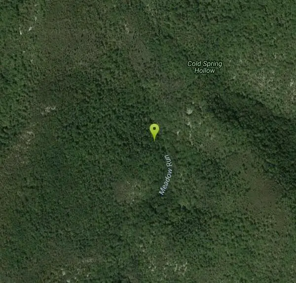


Other Swimming Holes and Hiking Trails Nearby

Sugar Hollow
Crozet, Virginia
2.7 miles SAn 11-mile loop starting and ending at Sugar Hollow Reservoir, passing Blue Hole and Rip Rap swimming holes — a hiker's way to combine challenge with a cool dip in Shenandoah.
Hike, Swim
Mint Springs Valley Park
Crozet, Virginia
6.9 miles STwo small lakes with sandy beaches, miles of forested hiking and mountain biking trails, a sand volleyball pit, and a playground — all in an eight-acre valley park near Crozet, Virginia.
Hike, Mountain Bike, Swim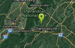
Charlottesville Area
Williamsville, Virginia
11.6 miles ETwo swimming spots north of Charlottesville, Virginia — a fee applies, so check details before heading out.
Swim
Pauls Creek
Nellysford, Virginia
18.6 miles SA quick 1.2-mile hike along Paul's Creek leads to a cascading waterfall and a natural water slide — stones smoothed by the water let visitors slide right into the swimming hole below.
Hike, Swim
Natural Chimneys
Mount Solon, Virginia
21.4 miles NWTowering vertical limestone formations draped in trees and vines, with shallow river swimming holes, 2.5 miles of hiking and biking trails, and a well-equipped 135-site campground.
Camp, Hike, Mountain Bike, Swim
Fridley Gap
Keezletown, Virginia
22.3 miles NA small, chest-deep swimming hole at the halfway point of a beautiful George Washington National Forest loop — cold all year and only 0.5 miles from the trailhead.
Hike, Swim
Stokesville Campground
Madison, Virginia
24.2 miles NWSwim near Madison, Virginia
Swim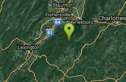
Campbell Creek
Tyro, Virginia
24.6 miles SWA 6-mile Appalachian Trail stretch with good elevation rewards remote explorers with a creek pool at the base of a waterfall — optional swimwear in this backcountry spot.
Swim
North River Gap
Mount Solon, Virginia
24.9 miles NWA free recreation area with an easy 2.4-mile river gorge hike through lush forest, a wading and swimming spot in the North River, and primitive campsites for $5 a night.
Camp, Hike, Swim
St. Mary's Falls
Raphine, Virginia
25.0 miles SWBlue-green water and unique low rock formations set the scene at this cascading waterfall swimming hole in St. Mary's Wilderness — a 4.4-mile out-and-back hike through George Washington National Forest.
Hike, Swim
Rapidan Rivers
Madison, Virginia
28.2 miles NESwimming holes beneath small waterfalls along the Rapidan River in Shenandoah, accessible on short hikes — protected waters known for trout and catfish fishing.
Swim 0.3 mi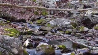
Big Rock Falls
Syria, Virginia
28.7 miles NEA moderately challenging 1.5-mile trail follows Mill Prong River to a beautiful cascading waterfall with a swimming hole that fills up nicely at higher water levels.
Hike, Swim
Rose River
Syria, Virginia
31.7 miles NEA moderately difficult 4-mile forested loop in Shenandoah National Park descending to the Rose River and a stunning 67-foot waterfall — wading is possible in some spots.
Hike, Swim
Big Marys Creek Slide
Vesuvius, Virginia
32.0 miles SWA natural waterslide that launches you into a swimming hole below, with waterfalls and cool water in the Virginia hills — wear swimwear and foot protection, and check depth first.
Swim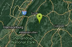
Old Rag Area
Crewe, Virginia
33.1 miles NESix swimming holes at the base of waterfalls and along rivers in Shenandoah National Park's Old Rag area, all reached by hikes of varying length from Skyline Drive or nearby routes.
Swim 2.8 mi
Cedar Run Falls
Oldrag, Virginia
33.1 miles NESix waterfalls, a natural waterslide, and a deep swimming hole reward experienced hikers who tackle this strenuous 8-mile, 2,794-ft-elevation Shenandoah trail.
Hike, Swim
Whiteoak Canyon
Syria, Virginia
34.4 miles NEA Shenandoah hike featuring both a two-tiered lower waterfall and a classic single-drop upper falls — with cool wading spots along the trail for a well-earned break before the 1,040-foot climb back.
Hike, Swim
Nicholson Hollow Trail
Morning Star, Virginia
37.2 miles NEAn 8-mile moderately strenuous Shenandoah hike past stream crossings, small cascading waterfalls, shaded forest, and the historic Corbin Cabin — wading is possible in low-flow conditions.
Hike, Swim 5.2 mi
Hazel River Falls
Sperryville, Virginia
40.8 miles NEA 5.3-mile moderate hike in Shenandoah National Park leading to two moss-covered waterfalls, a wading and swimming pool, flat sunbathing rocks, and small caves to explore.
Hike, Swim
Blue Hole Bergton
Bergton, Virginia
41.0 miles NA scenic day-use picnic area on a river in Rockingham County — flooding and erosion have made it shallower over time, best now for wading and enjoying the forest and rock surroundings.
SwimNearby Campsites
Natural Chimneys
Mount Solon, Virginia
21.4 miles NWTowering vertical limestone formations draped in trees and vines, with shallow river swimming holes, 2.5 miles of hiking and biking trails, and a well-equipped 135-site campground.
Camp, Hike, Mountain Bike, Swim
North River Gap
Mount Solon, Virginia
24.9 miles NWA free recreation area with an easy 2.4-mile river gorge hike through lush forest, a wading and swimming spot in the North River, and primitive campsites for $5 a night.
Camp, Hike, Swim


