


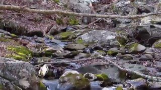
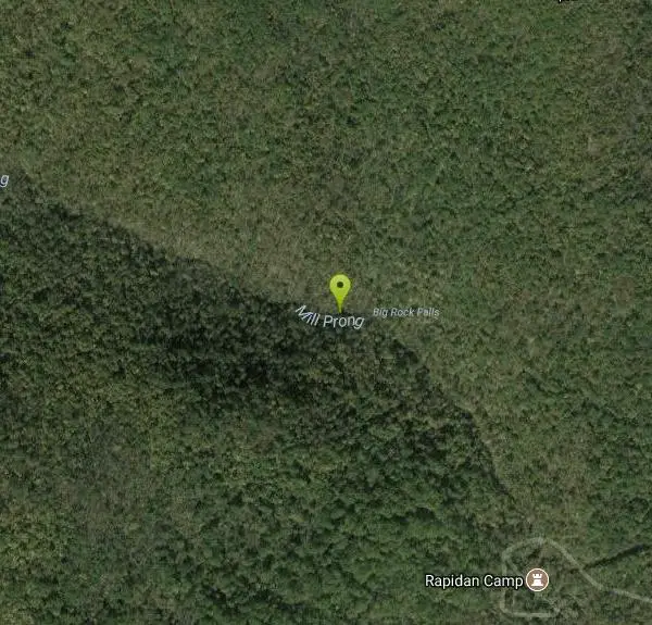
Big Rock Falls
Syria, Virginia
| GPS: |
38°29'43.4"N 78°25'26.8"W Maps | Directions |
| State: | Virginia |
| Trails/Routes: | 0.3 mi |
Rivers Waterfalls Trails
Hike and Swim
Big Rock Falls is an easy hike to a beautiful cascading waterfall. The hike follows Mill Prong River giving hikers a beautiful view of the flowing water, forests and rock formations for the entire hike. The hike to the Falls is 1.5 miles and is considered moderately difficult. There is a steady change in elevation and the trail is rocky. The trail is also well marked and easy to follow.
When the water is at higher flow there is a spot on Mill Prong river before you reach big falls where the water pools into a decent swimming hole. This gives visitors an opportunity to cool off and enjoy the clean water. Swimming is done at your own risk and swimmers should check water safety before swimming.
The fee to enter the park is $30 per vehicle. This pass is good for a week from time of purchase.
More Information
Big Rock Falls - 3D Map, Photos and Directions - Shenandoah National Park - Let’s See America
Near the retreat of a former U.S. President (Hoover) is lovely Big Rock Falls. Go here for a description, trail map and photos.
https://lets-see-america.com/big-rock-falls-in-virginia/Big Rock Falls: A Big Meadows Hike to a Tumbling Waterfall
Hike to Big Rock Falls from Big Meadows at Shenandoah National Park in Virginia. It’s a quiet hike with a hefty reward at the scenic falls.
https://gohikevirginia.com/big-rock-falls-shenandoah/swimmingholes.org VIRGINIA Swimming Holes and Hot Springs rivers creek springs falls hiking camping
THE web site for beautiful, natural places for a cool dip or hot soak.
https://www.swimmingholes.org/va.htmlBe courteous, informed, and prepared. Read trailhead guidelines, stay on the trail, and don't feed the wildlife.
Read More- Plan Ahead and Prepare
- Travel & camp on durable surfaces
- Dispose of waste properly
- Leave what you find
- Minimize campfire impacts
- Respect wildlife
- Be considerate of other visitors
Directions
From Syria, Virginia
- Head southeast on VA-670 toward Bohannon Rd (1.7 mi)
- Turn right onto State Rte 649 (2.4 mi)
- Continue onto Rapidan Rd (5.2 mi)
- Continue onto Rapidan Fire RdRestricted usage road(0.4 mi)
- Turn leftRestricted usage road(0.6 mi)

Other Swimming Holes and Hiking Trails Nearby

Rose River
Syria, Virginia
3.4 miles EA moderately difficult 4-mile forested loop in Shenandoah National Park descending to the Rose River and a stunning 67-foot waterfall — wading is possible in some spots.
Hike, Swim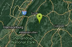
Old Rag Area
Crewe, Virginia
4.5 miles NESix swimming holes at the base of waterfalls and along rivers in Shenandoah National Park's Old Rag area, all reached by hikes of varying length from Skyline Drive or nearby routes.
Swim 2.8 mi
Cedar Run Falls
Oldrag, Virginia
4.5 miles NESix waterfalls, a natural waterslide, and a deep swimming hole reward experienced hikers who tackle this strenuous 8-mile, 2,794-ft-elevation Shenandoah trail.
Hike, Swim
Rapidan Rivers
Madison, Virginia
4.6 miles SESwimming holes beneath small waterfalls along the Rapidan River in Shenandoah, accessible on short hikes — protected waters known for trout and catfish fishing.
Swim
Whiteoak Canyon
Syria, Virginia
5.8 miles NEA Shenandoah hike featuring both a two-tiered lower waterfall and a classic single-drop upper falls — with cool wading spots along the trail for a well-earned break before the 1,040-foot climb back.
Hike, Swim
Nicholson Hollow Trail
Morning Star, Virginia
8.9 miles NEAn 8-mile moderately strenuous Shenandoah hike past stream crossings, small cascading waterfalls, shaded forest, and the historic Corbin Cabin — wading is possible in low-flow conditions.
Hike, Swim 5.2 mi
Hazel River Falls
Sperryville, Virginia
12.2 miles NEA 5.3-mile moderate hike in Shenandoah National Park leading to two moss-covered waterfalls, a wading and swimming pool, flat sunbathing rocks, and small caves to explore.
Hike, Swim
Fridley Gap
Keezletown, Virginia
15.4 miles WA small, chest-deep swimming hole at the halfway point of a beautiful George Washington National Forest loop — cold all year and only 0.5 miles from the trailhead.
Hike, Swim
Piney River
Sperryville, Virginia
16.9 miles NEMultiple swimming holes along Piney River — including one beneath a small waterfall — reached by following Cumberland Trail through the forest near Sperryville.
Hike, Swim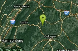
Rock Mills
Castleton, Virginia
19.3 miles NECLOSED. This property is owned by the Mt. Lebanon Baptist Church. Swimmers here without a permit will be prosecuted for trespassing. A classic all-American swimming hole with a tire and rope swing, a small sandy beach, and smaller pools for little ones — privately owned but open to the public near a historic country Baptist church.
Swim 3.8 mi
Overall Run Falls
Overall, Virginia
21.9 miles NVirginia's longest consecutive waterfall anchors a challenging 8-mile Shenandoah hike with rock scrambles, cool river rest spots, and a deep swimming hole for experienced swimmers.
Hike, Swim
Hazel Falls
Rixeyville, Virginia
23.9 miles EA remote cool, clear swimming hole with a dual waterfall — an upper rocky overhang shelter pool and a deeper lower pool — reached by a mile-plus hike on Hazel Mountain and White Rocks Trails.
Swim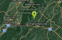
Charlottesville Area
Williamsville, Virginia
25.6 miles STwo swimming spots north of Charlottesville, Virginia — a fee applies, so check details before heading out.
Swim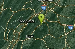
Overall Area
Crewe, Virginia
27.4 miles NSwim near Crewe, Virginia
Swim
Gooney Creek
Front Royal, Virginia
27.5 miles NCamp, Hike, and Swim near Front Royal, Virginia
Camp, Hike, Swim 6.1 mi
Rip Rap Hollow
Crozet, Virginia
28.7 miles SWA 50-foot, mountain-fed swimming hole on a difficult 10-mile Shenandoah Valley loop that also passes Chimney Rock and a scenic waterfall — cold, clear, and worth the effort.
Hike, Swim
Elizabeth Furnace
Strasburg, Virginia
30.4 miles NA recreation area in the Shenandoah with 32 electric campsites, miles of hiking and mountain biking trails, rock climbing access, and a Passage Creek swimming hole with a log to jump from.
Camp, Hike, Mountain Bike, Rock Climb, Swim 15.7 mi
Sugar Hollow
Crozet, Virginia
30.4 miles SWAn 11-mile loop starting and ending at Sugar Hollow Reservoir, passing Blue Hole and Rip Rap swimming holes — a hiker's way to combine challenge with a cool dip in Shenandoah.
Hike, Swim
Buzzard Rock Hole
Strasburg, Virginia
31.5 miles NA cold, clear, deep swimming hole below the iconic Buzzard Rock, with a sunbathing ledge all around — just note the rocky shallow bottom makes jumping unsafe.
Hike, Swim
Blue Hole Bergton
Bergton, Virginia
33.0 miles NWA scenic day-use picnic area on a river in Rockingham County — flooding and erosion have made it shallower over time, best now for wading and enjoying the forest and rock surroundings.
SwimNearby Campsites
Gooney Creek
Front Royal, Virginia
27.5 miles NCamp, Hike, and Swim near Front Royal, Virginia
Camp, Hike, Swim
Elizabeth Furnace
Strasburg, Virginia
30.4 miles NA recreation area in the Shenandoah with 32 electric campsites, miles of hiking and mountain biking trails, rock climbing access, and a Passage Creek swimming hole with a log to jump from.
Camp, Hike, Mountain Bike, Rock Climb, Swim
Natural Chimneys
Mount Solon, Virginia
37.0 miles WTowering vertical limestone formations draped in trees and vines, with shallow river swimming holes, 2.5 miles of hiking and biking trails, and a well-equipped 135-site campground.
Camp, Hike, Mountain Bike, Swim
North River Gap
Mount Solon, Virginia
40.9 miles WA free recreation area with an easy 2.4-mile river gorge hike through lush forest, a wading and swimming spot in the North River, and primitive campsites for $5 a night.
Camp, Hike, Swim


