


23 Free Swimming Holes near Upper Dry Creek Area Trails
first prev 1 2 next lastShowing Swimming Holes within 50 miles Distance miles of 1219 Dry Creek Rd, Sedona, AZ 86336, USA City, Zip, or Address

Chavez Crossing
Sedona, Arizona
3.6 miles SEChavez Crossing is a campground in Sedona, Arizona. It sits perfectly nestled in Arizona's most beautiful red rock attractions along with the grand summer sunsets. If that didn't sound...
Camp, Hike, Swim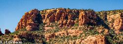
Red Rock State Park
Sedona, Arizona
3.9 miles SRed Rock in Sedona, Arizona details the beauty in the layers of sedimentary rock that has been constructed over millions of years. It is at Red Rock that you can see "Schnebly Hill...
Hike, Swim 3.4 mi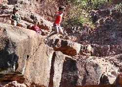
Grasshopper Point
Sedona, Arizona
5.0 miles EGrasshopper Point is a beautiful swimming hole located in Sedona, Arizona. Grasshopper Point is the perfect place to cool off in the summer after a nice hike, or a hot summer day. This swimming...
Dive, Hike, Swim 0.3 mi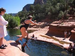
Slide Rock
Sedona, Arizona
5.7 miles NESlide Rock is one of the most popular locations in the Sedona area. Slide Rock is natures most thrilling water slides. Slide Rock is a gargantuan 80 feet long, and 2-4 feet wide. This slippery slope...
Hike, Swim 0.1-0.7 mi

Cave Springs
Sedona, Arizona
9.2 miles NECave Springs Campground is a scenic campground that sits in Oak Creek Canyon. Cave Springs is nestled perfectly in the town of Sedona, giving the campground the notorious Sedona red views. Uniquely,...
Camp, Hike, Swim 0.1 mi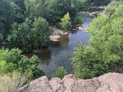
Mormons Crossing
Cornville, Arizona
10.3 miles SWMormons Crossing is a little area along Oak Creek in Cornville, Arizona. Along this creek there are several holes deep enough to swim in, some rapids, and even a rope swing. It's a great spot to...
Swim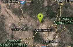
Sycamore Canyon
Sedona, Arizona
14.1 miles WA very pleasant 3.5 mile round trip hike down into a canyon and along a perennial stream to several swimming holes. Bathing suits: May be optional at farther...
Swim 7.1 mi
The Crack at Wet Beaver Creek
Rimrock, Arizona
15.5 miles SThe Crack is a popular swimming hole found by hiking the Bell Trail down to Wet Beaver Creek. After following the trail for about 3.5 miles away from the parking lot, take a detour to the left just...
Dive, Hike, Horseback, Swim
Beaver Creek Campground
Camp Verde, Arizona
15.8 miles SCamp, Canoe, Kayak, and Swim near Camp Verde, Arizona
Camp, Canoe, Kayak, Swim
Bullpen Day Use Area
Camp Verde, Arizona
24.4 miles SBullpen has something for everyone. Whether you park here and use the trail head to start on one of several hikes that lead down West Clear Creek, or stay nearby to use the picnic areas and...
Backpack, Dive, Hike, Swim 16.9 mi
West Clear Creek Trail No. 17
Camp Verde, Arizona
24.4 miles SWest Clear Creek Trail No. 17 is a great way to reach the running waters of West Clear Creek. By far the most accessible and popular, it starts from the Bull Pen Ranch parking lot and winds down the...
Backpack, Hike, Swim 3.0 miBlodgett Basin Trail No. 31
Camp Verde, Arizona
24.5 miles SBlodgett Basin Trail is one of a select few trails that shows off the riparian desert beauty unique to West Clear Creek Wilderness. The trail stretches from Bull Pen Trailhead through the canyon and...
Backpack, Hike, Swim 0.4 mi
Clear Creek Campground
Camp Verde, Arizona
25.4 miles SWest Clear Creek flows along the boundary of this desert canyon country camp and is a popular place for hiking, swimming, wading and fishing. Cool water species such as smallmouth bass and green...
Camp, Hike, Swim 0.6-2.9 mi
Tramway Trail No. 32
Happy Jack, Arizona
31.8 miles SETramway Trail is a very short but very steep hike down the ridge of the Colorado Plateau to the nearby West Clear Creek. The trail crosses over the sharp edge of the Mogollan Rim, and descends to the...
Hike, Rock Climb, Swim 1.9 mi
Maxwell Trail No. 37
Happy Jack, Arizona
32.8 miles SEThe Maxwell Trail leads over the Mongollan Rim down the canyon into West Clear Creek. Although still somewhat steep, it is an easier hike than shorter neighboring Tramway trail, which shares its...
Hike, Swim 1.1 mi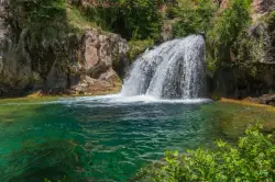
Fossil Creek Waterfall
Pine, Arizona
34.9 miles SFossil Creek is one of Arizona's two designated "Wild and Scenic" rivers. The waterfall is the most popular place to visit to cool off and see the natural beauty. Located between...
Hike, Swim 2.2-6.1 mi
Fossil Creek Dam (Toilet Bowl)
Pine, Arizona
35.8 miles SEHidden within the vast Arizona desert is an oasis of a river that brings the surrounding banks to life around it. This is Fossil Creek--one of Arizona's two designated "Wild and...
Dive, Hike, Swim 0.1-3.8 mi
Fossil Springs Trail No. 18
Pine, Arizona
35.8 miles SELocated within the Fossil Springs Wilderness, this trail leads down a canyon to the springs for which it is named. At the trailhead, there are several hikes, some of which are available for...
Hike, Horseback, SwimEast Clear Creek
Happy Jack, Arizona
43.8 miles SEEast Clear Creek is a river that stretches through the Mogollon Rim area of Arizona. It provides water to the surrounding desert landscape, fishing opportunities, and various areas to hike,...
Canyoneer, Hike, Swim 1.6-3.6 mi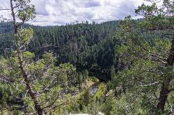
Kinder Crossing Trail #19
Happy Jack, Arizona
43.8 miles SEKinder Crossing Trail #19 travels down to the beauty of East Clear Creek, and then extends up until reaching FR 137; but many people use the trail to reach the creek waters and play in the water. The...
Hike, Swim


