


152 Things to do near Biscuit Basin to Fairy Falls and Firehole Meadows
first prev 1 2 3 4 5 6 7 8 next lastShowing results within 50 miles Distance miles of 85PFF3MC+XH City, Zip, or Address

Mammoth/Gardiner Back Road
Mammoth Hot Springs, Yellowstone National Park
35.8 miles NThe only road open in Yellowstone National Park is Highway 89 at Gardiner, Montana to park Headquarters at Mammoth Hot Springs and from Mammoth Hot Springs to Silver Gate and Cooke City, Montana.
Hike, Mountain Bike 4.0 mi
Lava Creek Trail
Mammoth Hot Springs, Yellowstone National Park
35.8 miles NLava Creek Trail is a 4.2 mile hike where hikers can enjoy walking along the scenic Lava Creek. The trail passes Undine Falls and the Gardner River. Undine Falls is a beautiful 60 foot...
Hike
Mammoth Hot Springs Campground
Mammoth Hot Springs, Yellowstone National Park
35.8 miles NMammoth Hot Springs Campground is the only campground in Yellowstone that is open to campers year-round. Campsites cannot be reserved and are available on a first come first served basis. It is...
Camp 7.4 mi
Blacktail Deer Creek to Yellowstone River Trail
Mammoth Hot Springs, Yellowstone National Park
36.4 miles NEBlacktail Deer Creek Trail is a 7 mile out and back trail that leads to the Yellowstone River. Hikers on this trail will enjoy seeing green open fields, boulder formations and waterfalls at the...
Hike
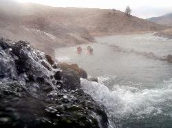
Boiling River
North Entrance, Yellowstone National Park
36.9 miles NThe Boiling River is created where a large hot spring enters the Gardner River, allowing the hot and cool waters to mix into a temperature comfortable enough to bathe in. The natural hot tub makes a...
Hot Springs, Swim
Howard Creek Trail
Island Park, Idaho
37.0 miles WThe Howard Creek trail follows Howard Creek upstream to the old Taylor Creek Road. The old Taylor Creek Road connects the Howard Creek trail to the Continental Divide Trail. Howard...
Mountain Bike
Forces of the Northern Range
Mammoth, Yellowstone National Park
37.3 miles NEThis short 1/2 mile boardwalk located on the Blacktail Deer Plateau between Mammoth Village and Tower Junction will open your eyes and educate you about forces of nature that have sculpted the land...
Hike 29.6 mi
Ashton to Tetonia Trail
Ashton, Idaho
37.9 miles SWThe Idaho Department of Parks and Recreation undertook the project to transform the old Teton Valley Branch of the Union Pacific Railroad from Ashton to Tetonia into a trail for bikes, ATVs, and...
Mountain Bike
Wade Lake
Cameron, Montana
38.4 miles NWCamp, Canoe, Kayak, and Swim near Cameron, Montana
Camp, Canoe, Kayak, Swim
Bitch Creek Trestle
Tetonia, Idaho
38.4 miles SAs part of the Rails to Trails project, this old railroad bridge has been transformed into a very safe little viewing experience for the whole family. You can drive right up to the bridge where...
Hike 0.8 mi
Conant Creek Pegram Truss Railroad Bridge
Ashton, Idaho
38.5 miles SWAs part of the Rails to Trails project, this old railroad bridge has been transformed into a very safe little viewing experience for the whole family. You can drive right up to the bridge where there...
Hike 7.9 mi
Rescue Creek Trail
Mammoth Hot Springs, Yellowstone National Park
38.6 miles NRescue Creek Trail is an 8 mile hike that crosses the Montana/Wyoming boarder. This double trail makes for a leisurely hike through beautiful hills and colorful yellow green grasslands. This trail,...
Hike
Tower Falls
Tower Junction, Yellowstone National Park
38.6 miles NETower Fall is a waterfall on Tower Creek in the northeastern region of Yellowstone National Park, in the U.S. state of Wyoming. Approximately 1,000 yards (910 m) upstream from the creek's...
Camp, Hike 3.3 mi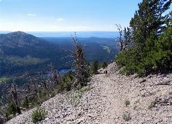
Avalanche Peak Trail
Cody, Wyoming
38.6 miles EAvalanche Peak Trail is a 4 mile trail to the peak of Avalanche Mountain. This is considered difficult because hikers will climb 2,100 feet in 2 miles. It is recommended that hikers bring...
Hike 2.4 mi
Lost Lake Trail
Tower Junction, Yellowstone National Park
38.7 miles NELost Lake Trail is a 2.8 mile hike that can be completed in less than two hours. This is an easy hike with very little elevation change. Hikers can enjoy forests, meadows and a view of Lost Lake...
Hike 8.2 mi
Garnet Hill Trail
Tower Junction, Yellowstone National Park
39.0 miles NEGarnet Hill Trail is a 7.6 mile loop that follows an old, dirt stagecoach road. This trail passes through large meadows, dusty areas with sagebrush, forests and beside the Yellowstone River. This...
Hike 10.1 mi
Sky Rim Trail to Sheep Mountain
Big Sky, Montana
39.1 miles NSky Rim Trail to Sheep Mountain is a challenging hike with stunning and famous views. This 10 mile out-and-back trail starts at Dailey Creek Trailhead (WK1). The trail follows Dailey Creek over...
Backpack, Hike 3.8 mi
Abandoned Railroad Bed Bike Trail
Gardiner, Montana
39.2 miles NThe Abandoned Railroad Bed Bike Trail, otherwise known as Shortline Trail, is a easily accessible bike trail found just inside the North Entrance of Yellowstone National Park. This bike trail follows...
Mountain Bike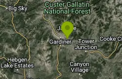
Coyote Creek Trail
Gardiner, Montana
39.5 miles Nnear Gardiner, Montana
0.3 mi
Yellowstone River Picnic Area Trail
Tower Junction, Yellowstone National Park
39.5 miles NEThe Yellowstone River Picnic Area trail is 3.9 miles loop trail. It is called the Yellowstone Picnic Area trail because the beginning of the trail is in a picnic area.This hike features a...
Hike


