


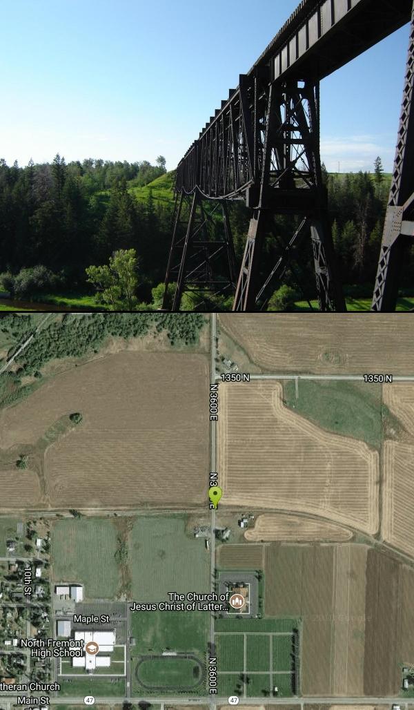
Ashton to Tetonia Trail
Ashton, Idaho

| Address: | N 3600 E, Ashton, ID 83420, USA |
| GPS: |
44°4'32.1"N 111°26'8.6"W Maps | Directions |
| State: | Idaho |
| Trails/Routes: | 29.6 mi |
Rivers Streams Trails Wildflowers
Mountain Bike
The Idaho Department of Parks and Recreation undertook the project to transform the old Teton Valley Branch of the Union Pacific Railroad from Ashton to Tetonia into a trail for bikes, ATVs, and snowmobiles, runners, cross-country skiers, and horses. The trail goes from Ashton to Tetonia and can be accessed via Ashton, Marysville, Bitch Creek, Felt, or Tetonia. Information can be found at kiosks in Marysville and at Bitch Creek.
Elevation Gain (Southbound): 787 ft
Length: 29.6 mi
SnakeRiverMountainBikeClub.com Trail Map
More Information
Ashton-Tetonia Trail | Biking in Eastern Idaho
Learn more about biking or snowshoeing the 30 mile Ashton-Tetonia Trail in eastern Idaho.
https://visitidaho.org/things-to-do/state-parks/ashton-to-tetonia/Ashton-Tetonia Trail | Idaho Trails | TrailLink
Ashton-Tetonia Trail spans 30 from N. 3600 E. (Ashton) to N. 3000 W. (Tetonia). View amenities, descriptions, reviews, photos, itineraries, and directions on TrailLink.
https://www.traillink.com/trail/ashton-tetonia-trail/Never modify trail features. Ride trails when they're dry enough that you won't leave ruts. Speak up when you see others on the trail and always yield to hikers, horses, and others coming uphill. Always ride on the established trail.
Read More- Plan Ahead and Prepare
- Travel & camp on durable surfaces
- Dispose of waste properly
- Leave what you find
- Minimize campfire impacts
- Respect wildlife
- Be considerate of other visitors
Directions
From Ashton, Idaho
- Head east on ID-47 N/Main St toward S 6th StContinue to follow ID-47 N(0.6 mi)
- Turn left onto N 3600 E (0.3 mi)


Other Mountain Bike Trails Nearby

Yellowstone Branch Line Trail
Ashton, Idaho
6.9 miles NEA 39-mile trail from Warm River to the Montana border — open to backpackers, hikers, mountain bikers, horseback riders, and ATVs through the Targhee National Forest.
Backpack, Cross-country Ski, Hike, Horseback, Mountain Bike
Big Bend Ridge Trail
Ashton, Idaho
11.3 miles NA smooth, swooping singletrack network near Driggs, Idaho with low elevation change, multiple route options, and a long riding season — one of the first trails to dry out each spring.
Mountain Bike
Flat Canyon Trail
Island Park, Idaho
15.8 miles NEA non-motorized trail in Island Park, Idaho — a peaceful ride through the forest with no engines to share the trail with.
Mountain Bike 0.6-4.7 mi
Harriman State Park
Island Park, Idaho
17.1 miles NAn 11,000-acre wildlife refuge 38 miles from Yellowstone along Henry's Fork — world-class fly-fishing, hiking among wildflowers and wildlife, plus 24 miles of Nordic ski trails in winter.
Cross-country Ski, Hike, Horseback, Mountain Bike, Snowshoe 17.5 mi
Tear Drop Lake
Ashton, Idaho
18.4 miles NEA small, lively lake in the Targhee forest for kayaking, swimming, and an easy loop trail — family fun with primitive lakeside camping.
Camp, Canoe, Hike, Kayak, Mountain Bike, Swim
Wright Creek Trail
Tetonia, Idaho
20.1 miles SA multi-use trail near Tetonia, Idaho open for mountain biking, horseback riding, snowshoeing, and hiking in Targhee National Forest terrain.
Mountain Bike 0.6 mi
Packsaddle Lake
Tetonia, Idaho
21.4 miles SA secluded, steep-access Teton lake with a 300-foot descent from the trailhead, water that drops off quickly at the edge, and a small camp on the eastern shore.
Dive, Hike, Mountain Bike, Snowshoe, Swim 2.9 mi
Box Canyon Trail
Island Park, Idaho
23.5 miles NA scenic 3-mile riverside singletrack along Henry's Fork in Box Canyon — open to OHVs under 50 inches wide, with river views most of the trail and great trout fishing.
Hike, Mountain Bike
Probation And Burg Bumper
Tetonia, Idaho
23.8 miles SThe steepest downhill in the Tetonia area — a mile of bridges and log jumps on Probation, with the climbing Burg portion returning you to a 5-way junction with options to extend your ride.
Mountain Bike 0.1-1.3 mi
Hidden Valley Trails
Rexburg, Idaho
24.0 miles SWA well-signed network of downhill singletrack flows around the edges of Rexburg, with trails like Flow State, Drop Zone, and Lil' Sendy for every ability level.
Hike, Mountain Bike 0.4-0.7 mi
Rexburg Bike Park
Rexburg, Idaho
24.2 miles SWA beginner-friendly bike park behind Rexburg Rapids with mounts in small, medium, and large sizes — and the same hills turn into great sledding terrain when snow arrives in winter.
Mountain Bike, Sled 0.2-0.5 mi
Eagle Park
Rexburg, Idaho
24.5 miles SWA cottonwood forest park inside Rexburg city limits with campsites, fishing, a dog park, mountain biking on easy and moderate loops, and rock-throwing by the river.
Camp, Hike, Mountain Bike, Sled
Sharks Belly
Driggs, Idaho
25.3 miles SA loop network connecting Channel Lock, Sodbusters, Cody's Loop, and Shark's Belly through pine-needle-carpeted singletrack in the Tetons — a smooth, secluded, tree-lined ride.
Mountain Bike
Channel Lock
Driggs, Idaho
25.4 miles SA short, smooth 1-mile access trail to the Horseshoe Canyon trail system near Driggs — fast and fun going down, with aspen stands, sagebrush, and 13 bermed turns.
Mountain Bike
Southbound
Driggs, Idaho
25.4 miles SAn open sagebrush hillside MTB trail with sweeping Teton Range views, a small tree section, and a mostly XC up-and-down feel — one of the first trails to dry out in spring.
Mountain Bike
Horseshoe Canyon
Tetonia, Idaho
25.4 miles SSmooth, swooping singletrack close to Driggs with varied route options, low elevation, and a dry climate that makes it one of the first trails to open each season.
Mountain Bike
Horseshoe Trails
Driggs, Idaho
25.5 miles SMountain Bike near Driggs, Idaho
Mountain Bike
Bovine
Driggs, Idaho
25.5 miles SA steep climb that pays you back with a fast, flowing downhill through smooth dirt and well-maintained berms — one of the first trails to open in spring and last to close in fall.
Mountain Bike
North Mahogany Trail #220
Tetonia, Idaho
25.5 miles SA multi-use trail open to motorbikes, mountain bikes, horses, and hikers — often accessed via South Horseshoe Trail (219) and paired with Nickerson Grove Trail (195) for a great loop.
Mountain Bike 0.5-3.5 mi
Webster's Dam
Ririe, Idaho
27.4 miles SAn abandoned dam in Moody Creek canyon where sediment split the stream into two beautiful 15-foot waterfalls — stunning in spring runoff and blazing with fall colors.
Camp, Hike, Mountain BikeNearby Campsites

Warm River Campground
Ashton, Idaho
7.0 miles NESlow-moving warm water and willow-lined banks make this campground a perfect spot for tubing, trout fishing, and peaceful mountain biking at 5,200 ft elevation.
Camp 0.3-0.6 mi
Bear Gulch
Ashton, Idaho
9.1 miles NEAn abandoned ski hill from 1969 with overgrown runs that still deliver great sledding — the lower run is fast and winding all the way down to the old ski lift.
Camp, Cross-country Ski, Hike, Sled
Porcupine Creek
Ashton, Idaho
10.8 miles EA backcountry hunting, fishing, camping, and swimming spot in Targhee National Forest, surrounded by forests, meadows, a creek, and unmarked trails — bear country, so pack and store food carefully.
Camp, Swim
Sheep Falls on Fall River
Ashton, Idaho
17.1 miles EA local gem off Cave Falls Road where the river splits into multiple falls tumbling over each other — primitive campsites and beautiful views make it a great picnic stop.
Camp
Horseshoe Lake
Ashton, Idaho
17.6 miles EA lily-pad-dotted lake hidden in the Targhee National Forest with a gradual beach entry perfect for wading, a floating dock for jumping, and no motorized boats.
Camp, Canoe, Dive, Swim 17.5 mi
Tear Drop Lake
Ashton, Idaho
18.4 miles NEA small, lively lake in the Targhee forest for kayaking, swimming, and an easy loop trail — family fun with primitive lakeside camping.
Camp, Canoe, Hike, Kayak, Mountain Bike, Swim
Cave Falls of Yellowstone
Ashton, Idaho
22.2 miles EA campground right on the Fall River along Yellowstone's south boundary puts you steps from legendary fishing, with fire rings and bear-proof boxes at each site.
Camp, Hike
Pine Butte / The Caldera
St. Anthony, Idaho
23.1 miles NWAn old volcano in the Idaho desert that feels like stepping into a mountain forest — pine-covered hillsides, a meadow ringed by aspen and boulders, and a quarter-mile easy trail to the caldera floor.
Camp, Hike, Horseback
Loon Lake
Ashton, Idaho
24.2 miles ECamp, Kayak, and Swim near Ashton, Idaho
Camp, Kayak, Swim 0.2-0.5 mi
Eagle Park
Rexburg, Idaho
24.5 miles SWA cottonwood forest park inside Rexburg city limits with campsites, fishing, a dog park, mountain biking on easy and moderate loops, and rock-throwing by the river.
Camp, Hike, Mountain Bike, Sled 0.9 mi
Buffalo River Campground
Island Park, Idaho
24.6 miles NAn easy, clear, and often warm float on the Buffalo River near Island Park, with slow enough current to paddle back upstream in a canoe or kayak after your run.
Camp, Canoe, Kayak, Swim 0.8-1.3 mi
Warm Slough Campground
Rexburg, Idaho
25.7 miles SWA popular river campground with two boat ramps and an easy, slow-moving inner tube float — the take-out is 1,000 feet from the put-in, making multiple runs a breeze.
Airsoft, Camp, Canoe
Moody Meadows
Driggs, Idaho
27.3 miles SGood place for kids, they can ride bikes in the meadow, play in the stream, and camping is off of the road. Hiking, motorbiking, and horseback riding trails are abundant in the area.
Camp 0.5-3.5 mi
Webster's Dam
Ririe, Idaho
27.4 miles SAn abandoned dam in Moody Creek canyon where sediment split the stream into two beautiful 15-foot waterfalls — stunning in spring runoff and blazing with fall colors.
Camp, Hike, Mountain Bike
Upper Coffee Pot Campground
Island Park, Idaho
28.9 miles NHenry's Fork of the Snake River winds through a lodgepole pine forest past this campground, offering fly-fishing for rainbow and brook trout and easy tubing and canoeing.
Camp, Canoe
Big Hole Dispersed Campsites
Ririe, Idaho
29.1 miles SA network of dispersed campsites with fire rings in the Big Hole mountains above Kelly Canyon — first come, first served, no reservations, and Leave No Trace principles are essential.
Camp
Beaver Dick Park
Rexburg, Idaho
29.1 miles SWA 9.5-acre Snake River park near Rexburg with fire pits, pavilions, fishing, boating, swimming, and a rich history tied to legendary frontiersman Beaver Dick Leigh.
Camp, Canoe, Disc Golf, Swim
Big Springs
Island Park, Idaho
30.5 miles NA Big Springs campground shaded by Lodgepole Pines on Henry's Fork — with a 1-mile interpretive trail, fish feeding under the bridge, the historic Johnny Sack Cabin, and access to the Mesa Falls Scenic Byway.
Camp, Hike
Table Rock Campground
Ririe, Idaho
31.7 miles SA campground in Caribou-Targhee National Forest — part of a 3-million-acre stretch from Montana to the Utah and Wyoming borders — with access to the Curlew National Grassland.
Camp
Paramount Wall / Blanche Rock
Ririe, Idaho
32.1 miles SA sport climbing wall above the road near Ririe with great exposure, afternoon shade, and well-loved 5.9–5.10 lines — most routes work with a 50-meter rope, established by Chuck Oddette and crew.
Camp, Horseback, Rock Climb


