


136 Things to do near Firehole River
first prev 1 2 3 4 5 6 7 next lastShowing results within 50 miles Distance miles of Firehole Canyon Rd, Yellowstone National Park, WY 82190, USA City, Zip, or Address

Sepulcher Mountain Trail
Mammoth Hot Springs, Yellowstone National Park
25.7 miles NSepulcher Mountain Trail is an 11 mile loop trail from Mammoth Hot Springs to the peak of Sepulcher Mountain. This is a challenging hike with a 3,500 foot ascent to the 9,652 foot peak. The...
Hike 5.3 mi
Beaver Ponds Trail
Mammoth, Yellowstone National Park
25.7 miles NBeaver Ponds Trail is a wonderful short hike accessible from Mammoth Hot Springs. The trail forms a loop between the two trailheads available at Mammoth Hot Springs. The loop is just over 5 miles...
Hike 0.1-5.2 mi
Mammoth Hot Springs
Mammoth, Yellowstone National Park
25.7 miles NMammoth Hot Springs is a unique sight in Yellowstone National Park. The soft limestone in this area allowed the water to form colorful terraces. The extremely hot running water is clear and smooth,...
Camp, Hike 0.1 mi
Lewis Lake Campground
Grant Village, Yellowstone National Park
25.9 miles SELewis Lake is located in the southern part of Yellowstone National Park. It is 4 miles southeast of Shoshone Lake. Lewis Lake offers a plethora great water activities. This lake offers...
Camp, Canoe, Kayak
Mammoth/Gardiner Back Road
Mammoth Hot Springs, Yellowstone National Park
26.0 miles NThe only road open in Yellowstone National Park is Highway 89 at Gardiner, Montana to park Headquarters at Mammoth Hot Springs and from Mammoth Hot Springs to Silver Gate and Cooke City, Montana.
Hike, Mountain Bike 4.0 mi
Lava Creek Trail
Mammoth Hot Springs, Yellowstone National Park
26.0 miles NLava Creek Trail is a 4.2 mile hike where hikers can enjoy walking along the scenic Lava Creek. The trail passes Undine Falls and the Gardner River. Undine Falls is a beautiful 60 foot...
Hike
Mammoth Hot Springs Campground
Mammoth Hot Springs, Yellowstone National Park
26.1 miles NMammoth Hot Springs Campground is the only campground in Yellowstone that is open to campers year-round. Campsites cannot be reserved and are available on a first come first served basis. It is...
Camp
Upper Coffee Pot Campground
Island Park, Idaho
26.4 miles WUpper Coffeepot Campground stretches along a floatable section of Henry's Fork of the Snake River. A mixed growth lodgepole pine forest provides partial shade and summer wildflowers are...
Camp, Canoe
Coffee Pot Rapids Trail
Island Park, Idaho
26.5 miles WHiker and fisherman parking is available at the campground entrance. Coffee Pot Rapids trail is 2.2 miles in length, is a non-motorized trail that follows the Henry's Fork of the Snake...
Mountain Bike 7.4 mi
Pelican Valley Trail
Lake Village, Yellowstone National Park
26.6 miles EPelican Valley Trail is a beautiful 6.2 mile hike that allows hikers to see Yellowstone Lake, Pelican Springs and the Pelican Valley water features. Despite its length this is an easy, level...
Hike 2.1 mi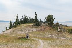
Storm Point Trail
Lake Village, Yellowstone National Park
26.6 miles EStorm Point Trail is a beautiful 2.3 mile hike that can be completed in under 2 hours. This is an easy hike with very little elevation change that is perfect for families with children. Hikers on...
Hike 7.4 mi
Blacktail Deer Creek to Yellowstone River Trail
Mammoth Hot Springs, Yellowstone National Park
26.7 miles NEBlacktail Deer Creek Trail is a 7 mile out and back trail that leads to the Yellowstone River. Hikers on this trail will enjoy seeing green open fields, boulder formations and waterfalls at the...
Hike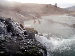
Boiling River
North Entrance, Yellowstone National Park
27.2 miles NThe Boiling River is created where a large hot spring enters the Gardner River, allowing the hot and cool waters to mix into a temperature comfortable enough to bathe in. The natural hot tub makes a...
Hot Springs, Swim

Forces of the Northern Range
Mammoth, Yellowstone National Park
27.6 miles NEThis short 1/2 mile boardwalk located on the Blacktail Deer Plateau between Mammoth Village and Tower Junction will open your eyes and educate you about forces of nature that have sculpted the land...
Hike 0.9 mi
Buffalo River Campground
Island Park, Idaho
28.1 miles SWThe float here is nice and easy. It's a great early season float. Later in the season the shallow spots will force you to walk a good chunk of the float. The water is super clear and often pretty...
Camp, Canoe, Kayak, Swim 7.9 mi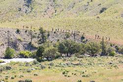
Rescue Creek Trail
Mammoth Hot Springs, Yellowstone National Park
28.8 miles NRescue Creek Trail is an 8 mile hike that crosses the Montana/Wyoming boarder. This double trail makes for a leisurely hike through beautiful hills and colorful yellow green grasslands. This trail,...
Hike
Sawtell Peak Trail
Island Park, Idaho
29.2 miles WThis trail offers great views of the valley floor, mountain peaks and wildlife. source: fs.usda.gov
Mountain Bike 7.6 mi
Mount Jefferson
Island Park, Idaho
29.2 miles WMount Jefferson, at 10, 203 feet is the highest point in the Centennial Mountains, a small, local range on the border of Idaho and Montana a little west of Yellowstone. These mountains consist of a...
Hike 4.2 mi
Lake Marie
Island Park, Idaho
29.2 miles WLake Marie sits on the North slope of Mount Jefferson in Fremont County, Idaho. The trail to get there cuts back and forth across the Idaho Montana border 4 times. Much of the trail is fairly flat...
Backpack, Hike
Cabin Creek
West Yellowstone, Montana
29.5 miles NWStarts out as a nice, buff trail. After a mile or two, there are a lot of tough creek crossings and when I rode it in 2010 there were a lot of trees down. This was from a recent...
Mountain Bike


