


241 Things to do near Hidden Vista / Pine Loop
first prev 1 2 3 4 5 6 7 8 9 10 next lastShowing results within 50 miles Distance miles of Forest Road 218, Ririe, ID 83443, USA City, Zip, or Address
Trail Canyon Trail
Ririe, Idaho
16.0 miles EThe Trail Canyon trail begins at Trail Canyon Parklot, T8s R43e Sec28 and ends at Intersect Trail 5251,t8s R43e Sec28. source: fs.usda.gov
Mountain Bike
Horseshoe Canyon
Tetonia, Idaho
16.1 miles EHorseshoe Canyon is one of the closest trail systems to the town of Driggs, Idaho. This network doesn't have a ton of climbing or descending, but the smooth, swooping singletrack with a...
Mountain Bike 0.4-0.7 mi
Rexburg Bike Park
Rexburg, Idaho
16.1 miles NWIt's a small but great bike park for all ages; if you are a beginner, then this is the bike park to go to. The mounts are a decent size and approximately 4-6 mounts in different sizes for the...
Mountain Bike, Sled
Bovine
Driggs, Idaho
16.2 miles EBovine trail is part of a larger system. You can use it to access more trails or make it your end destination from other trailheads. It is a steep climb but returns the favor with a fast downhill....
Mountain Bike
Horseshoe Trails
Driggs, Idaho
16.2 miles EMountain Bike near Driggs, Idaho
Mountain Bike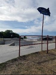
Rigby Skate Park
Rigby, Idaho
16.3 miles WThis is a fairly small concrete skate park. It has a couple of half bowls, a few sets of steps, a couple ramps, and a few rails. There's a lot of extra pavement for practicing your flat...
Skateboard 0.1-0.3 mi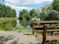
Rexburg Nature Park
Rexburg, Idaho
16.6 miles NWRexburg Nature Park: Life can be stressful, annoying, or just not good. Sometimes, it takes a moment to simply get away from the non-sense of this world; to gather yourself and seek peace and...
Disc Golf 0.1-0.5 mi
Eagle Park
Rexburg, Idaho
16.6 miles NWEagle Park is a little urban oasis. Once you drive in to this cottonwood forest along the river, you may forget that you're still inside Rexburg city limits. You can camp, picnic, throw rocks in...
Camp, Hike, Mountain Bike, Sled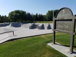
Claire Boyle Skatepark
Rexburg, Idaho
16.7 miles NWThere are 2 bowls right next to each other plus several boxes quarter pipes and rails. It's not huge but it's also rarely crowded. It's all concrete with metal edge, specially for...
Skateboard
Channel Lock
Driggs, Idaho
16.7 miles ETrail is a little over 1 mile uphill. Recommended route up to access the larger Horseshoe canyon trail system. Makes a nice downhill with twists. Gets its name from the deep ruts made from cows....
Mountain Bike
Southbound
Driggs, Idaho
16.8 miles ETrail starts by going up the Channel lock trail. At the top of Channel Lock go right onto the Southbound trail. Trail will loop back to Channel lock which you take back to your car. Trail is...
Mountain Bike
Sharks Belly
Driggs, Idaho
16.8 miles ETrail system can start from Channel lock or Bovine. Channel Lock is an easier climb than Bovine. This description and mileage starts at the Channel Lock trail, forest service boundary marker. Take...
Mountain Bike
Echo Canyon aka Fall Creek
Ririe, Idaho
17.5 miles SETrail goes to the top of Deadhorse Ridge for some amazing views. Double-track, single-track, and gravel road. Length: 15 miles
Mountain Bike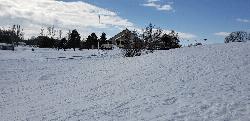
Teton Lakes Golf Course
Rexburg, Idaho
17.5 miles NWThis golf course is open year round, for golfing in the summers to cross country skiing in the winter. During the winter the course has over two miles of groomed cross country ski trails. You can...
Cross-country Ski, Sled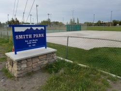
Smith Park
Sugar City, Idaho
17.6 miles NWSugar Hill is a smaller sledding hill in Sugar City's Smith Park. It's great for younger kids or just some quick runs. You can often get a good run on every side.
Skateboard, Sled
Park on Center St
Sugar City, Idaho
17.7 miles NWSled near Sugar City, Idaho
Sled
Fall Creek Falls
Swan Valley, Idaho
17.8 miles SEFalls Campground is located next to the Snake River near beautiful Swan Valley, only 45 miles east of Idaho Falls, Idaho. Mixed growth cottonwood trees provide partial shade, and grassy meadows with...
Camp, Cave, Hike, Kayak, Swim
Echo/Indian Creek Trail
Swan Valley, Idaho
17.9 miles SEOHV trail. source: fs.usda.gov
Mountain Bike
Marshall's
Saint Anthony, Idaho
18.0 miles NMarshall's Wave is located on the North Fork of the Teton River, where the Teton River splits into the north and south forks. The wave is created by a headgate and is best at flows above 600...
Kayak
Sucky Courtney's
Saint Anthony, Idaho
18.0 miles NKayaker playing in Marshall's Wave near Rexburg, Idaho. The wave is located on the North Fork of the Teton River and is best at flows above 600 cfs. The wave is good for beginners. It has a...
Kayak


