


239 Things to do near Loon Lake
first prev 1 2 3 4 5 6 7 8 9 10 next lastShowing results within 50 miles Distance miles of Forest Rd 022, Alta, WY 83414, USA City, Zip, or Address

Darby Wind Cave
Driggs, Idaho
29.5 miles SDarby Wind Cave is a beautiful hike full of waterfalls, wildflowers, streams, and mountainous views. The sites you see will depend on the time of year you visit but it will always be beautiful and...
Backpack, Cave, Hike, Rock Climb 0.9 mi
Buffalo River Campground
Island Park, Idaho
29.8 miles NWThe float here is nice and easy. It's a great early season float. Later in the season the shallow spots will force you to walk a good chunk of the float. The water is super clear and often pretty...
Camp, Canoe, Kayak, Swim 5.8 mi
Box Canyon Trail
Island Park, Idaho
30.1 miles NWVarious species of tress and wildflowers can be seen on the trail, as well as songbirds, waterfowl and occasional wildlife. The trail is open for the following uses: Motorcycle Trail Riding, Off...
Hike, Mountain Bike
Darby Canyon Cliffs
Alta, Wyoming
30.3 miles SAn interesting cave by Darby Canyon is the major draw to this popular west slope hike, closely followed by intermittent waterfalls splashing down the canyon rim along with impressive displays of...
Rock Climb
Box Canyon Island Park
Island Park, Idaho
30.3 miles NWThe Box Canyon Campground is situated on the canyon rim above the Henry's Fork of the Snake River. There are 16 single and 2 double units, each having tent and camper pads, fire rings, grills...
Canoe 0.6 mi
Packsaddle Lake
Tetonia, Idaho
30.4 miles SWPacksaddle is one of the less well known lakes/trails in the area. If you've got a good offroad vehicle, you can probably make it all the way to the end of the road, otherwise, it's just an...
Dive, Hike, Mountain Bike, Snowshoe, Swim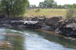
Fall River Bridge
Ashton, Idaho
30.5 miles WRight off Highway 20, there's a great spot to swim, swing, and dive. There's pullouts for parking right next to the bridge. There's a rope swing under the railroad bridge and a little...
Dive, Swim
Darby Canyon Camping
Alta, Wyoming
30.5 miles SThere's no official campgrounds up the canyon but there are several dispersed campsites with existing fire lays. Please adhere to principles of Leave No Trace. Use existing fire lays and leave...
Camp
Big Springs
Island Park, Idaho
30.6 miles NWThere's also a great little walking trail along the river with placards that tell about the ecosystem and history of the area. There's about a 1/2 mile that's paved and then a 1/2 mile...
Camp, Hike
Boundary Trail
Island Park, Idaho
30.7 miles NWBoundary Trail, (Trail #272 and #244) is a 37 mile loop trail that allows stock travel, mountain bike, motorcycle and ATV travel. This trail can be reached by several trailheads,...
Mountain Bike

Probation And Burg Bumper
Tetonia, Idaho
31.3 miles SWThe Probation part of the trail is the steepest downhill in the area. Has multiple bridges and log jumps in the short mile down. The Burg portion of the trail is uphill with some...
Mountain Bike
Wright Creek Trail
Tetonia, Idaho
31.3 miles SWOpen to MTB, horseback riding, snowshoeing, and hiking. source: fs.usda.gov
Mountain Bike
Sharks Belly
Driggs, Idaho
31.3 miles SWTrail system can start from Channel lock or Bovine. Channel Lock is an easier climb than Bovine. This description and mileage starts at the Channel Lock trail, forest service boundary marker. Take...
Mountain Bike
Southbound
Driggs, Idaho
31.4 miles SWTrail starts by going up the Channel lock trail. At the top of Channel Lock go right onto the Southbound trail. Trail will loop back to Channel lock which you take back to your car. Trail is...
Mountain Bike
Channel Lock
Driggs, Idaho
31.4 miles SWTrail is a little over 1 mile uphill. Recommended route up to access the larger Horseshoe canyon trail system. Makes a nice downhill with twists. Gets its name from the deep ruts made from cows....
Mountain Bike
Twin Creek Trail
Driggs, Idaho
31.5 miles SWThe Twin Creek trail is 2.3 miles long. It begins at Trail 6195 and ends at Trail 6219. source: fs.usda.gov
Mountain Bike
Twin Bridges
St. Anthony, Idaho
31.5 miles WThere's an old abandoned bridge next to the one currently in use. The water is pretty deep underneath and offers two distinct levels to jump from. There's a little rope swing under the bridge...
Dive, Swim 4.0 mi
Fountain Freight Road Bike Trail
31.9 miles N
Fountain Freight Road Bike Trail is a four mile stretch of paved road along Fairy Falls Trail. This stretch of trail is no longer open to vehicles but allows bikes. Despite being paved, it is...
Mountain Bike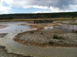
Sentinel Meadows & Queen's Laundry
Madison, Yellowstone National Park
31.9 miles NThe hike to Sentinel Meadows and Queens Laundry gives you a level trail with wide open meadows, hot springs, ponds, birds, and a little bit of Yellowstone National Park history. The trail can be done...
Hike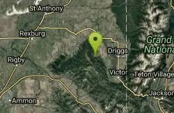
Horseshoe Canyon
Tetonia, Idaho
31.9 miles SWHorseshoe Canyon is one of the closest trail systems to the town of Driggs, Idaho. This network doesn't have a ton of climbing or descending, but the smooth, swooping singletrack with a...
Mountain Bike


