


233 Things to do near Mount Timpanogas
first prev 1 2 3 4 5 6 7 8 9 10 next lastShowing results within 50 miles Distance miles of Timpooneke Trailhead, Provo, UT 84604, USA City, Zip, or Address

Red Rock Trail
Draper, Utah
12.1 miles WThe Red Rock trail located in Draper, Utah is a short loop trail just down the road from the Draper LDS Temple. The hike itself may be short, but since it is along the cliffs of the southern end of...
Hike, Mountain Bike, Rock Climb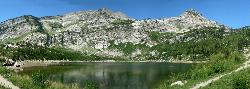
Silver Lake (Big Cottonwood)
Brighton, Utah
12.2 miles NThis hike has everything. The trail passes by three bodies of water and winds through beautiful woodland areas. Wildlife is in abundance. Everything from chipmunks to moose can be observed along...
Hike, Mountain Bike
Lake Blanche
Salt Lake City, Utah
12.4 miles NLake Blanche is a fun and popular hike. Lake Blanche, Lake Florence and Lake Lillian are all located next to each other in the upper reaches of the South Fork of Mill B. The trail to Lake Blanche...
Hike 1.1-4.7 mi
Bells Canyon
Sandy, Utah
12.6 miles NWBells Canyon is a moderate, 4.5 mile hike that begins in a residential area and ends at a waterfall in the enter of the canyon's forest. The first 1/2 mile of the hike is relatively...
Backpack, Hike, Mountain Bike, Snowshoe
Jupiter Peak Road
Salt Lake City, Utah
12.9 miles NGrind up from Guardsman Pass Road, passing the top of the Park City's Jupiter lift, and then out a ridge with amazing views both north and south. At the end, you can walk up to the very...
Mountain Bike
Wasatch Crest
Salt Lake City, Utah
12.9 miles NThe Wasatch Crest Trail (GWT) is probably one of the best, if not the very best, singletrack trail in Utah! I prefer to do this ride as an out and back, starting at Millcreek Canyon's Big Water...
Hike, Mountain Bike
Scott's Bypass
Brighton, Utah
12.9 miles NScott's Bypass begins right off the top of Guardsman's Pass and bypasses some of the gravel road on the way up to the top of Pinecone and the Wasatch Crest Trail. In and of itself,...
Mountain Bike
Y-Mountain Summit Trail
Provo, Utah
12.9 miles SY Mountain is located directly east of Brigham Young University (BYU) in Provo, Utah, United States. The Slide Canyon/Y Mountain Trail leads to a large block Y located 1.2 miles (1.9 km) from a...
Camp, Hike
Prospect Ridge / Ontario Ridge
Salt Lake City, Utah
13.0 miles NProspect Ridge runs from Daly Grind down to Prospect Avenue. This is a steep, rocky descent that is almost fall line-style, straight down the mountain to town. By Park City standards,...
Mountain Bike 0.5 mi
Draper City Park
Draper, Utah
13.0 miles NWDraper City Park is located in the center of the Draper Town Center and the park is near the Porter Rockwell Trail and Willow Creek Trail so visitors can walk or jog around. There are trail heads for...
Hike
Wasatch Mountain State Park
Park City, Utah
13.2 miles NEWasatch Mountain State Park, in beautiful Heber Valley, is Utahs most developed state park. Tucked away in the beautiful Wasatch Mountains, the park is both a summer and winter...
Mountain Bike

Shadow Lake Trail
Salt Lake City, Utah
13.6 miles NShadow Lake Trail in Park City provides a very scenic biking experience to cruise along. There are many fantastic biking opportunities in this high-altitude alpine area. You can ride the Shadow...
Mountain Bike
Dead Tree
Park City, Utah
13.7 miles NDead Tree is a .52 mile singletrack trail that connects to Jupiter Peak Road and the Apex trail. This is a high-alpine trail with some great singletrack.
Mountain Bike
Payroll
Park City, Utah
13.9 miles NEPayroll is less than a mile long, but it is a rowdy .67 miles! Payroll features some massive berms, swoops, plenty of rocks, kickers, doubles, a few sizeable drops, and another scoop of...
Mountain Bike
TG
Park City, Utah
14.0 miles NETG is an advanced singletrack trail with one section of doubletrack thrown in that has some rocks, drops, and sharp switchbacks. It's located high up on the side of the mountain....
Mountain Bike
Provo River
Provo, Utah
14.3 miles SThe Provo River is one of Utah's 'Urban Fisheries'.The Provo River is located in Utah County and Wasatch County, Utah, in the United States. It rises in the Uinta Mountains at Washington...
Canoe
Chopped Coyote Loop
Heber City, Utah
14.4 miles NEThe Coyote Canyon Loop lies northeast of Heber. It's a big ride that's best reserved for conditioned riders. Much of the trail is easier-intermediate technical, but there are many tight...
Mountain Bike
Storm Mountain
Salt Lake City, Utah
14.4 miles NStorm Mountain is on of the smaller peaks included in the Wasatch Range. Storm Mountain is located in Cottonwood Canyon. Storm Mountain Day Use Area is just 3 miles up Big Cottonwood Canyon,...
Hike, Mountain Bike, Rock Climb
Spruces Campground
Salt Lake City, Utah
14.5 miles NCamping isn't free. See USDA.gov for details. If you know the coordinates of the sledding hill here, please comment.
Camp, Sled
Ferguson Canyon
Cottonwood Heights, Utah
14.7 miles NWFerguson canyon is small canyon between Big and Little Cottonwood Canyons. This canyon has gained popularity over the last few year and is a popular destination for rock climbers. This is one hike...
Hike, Mountain Bike, Rock Climb


